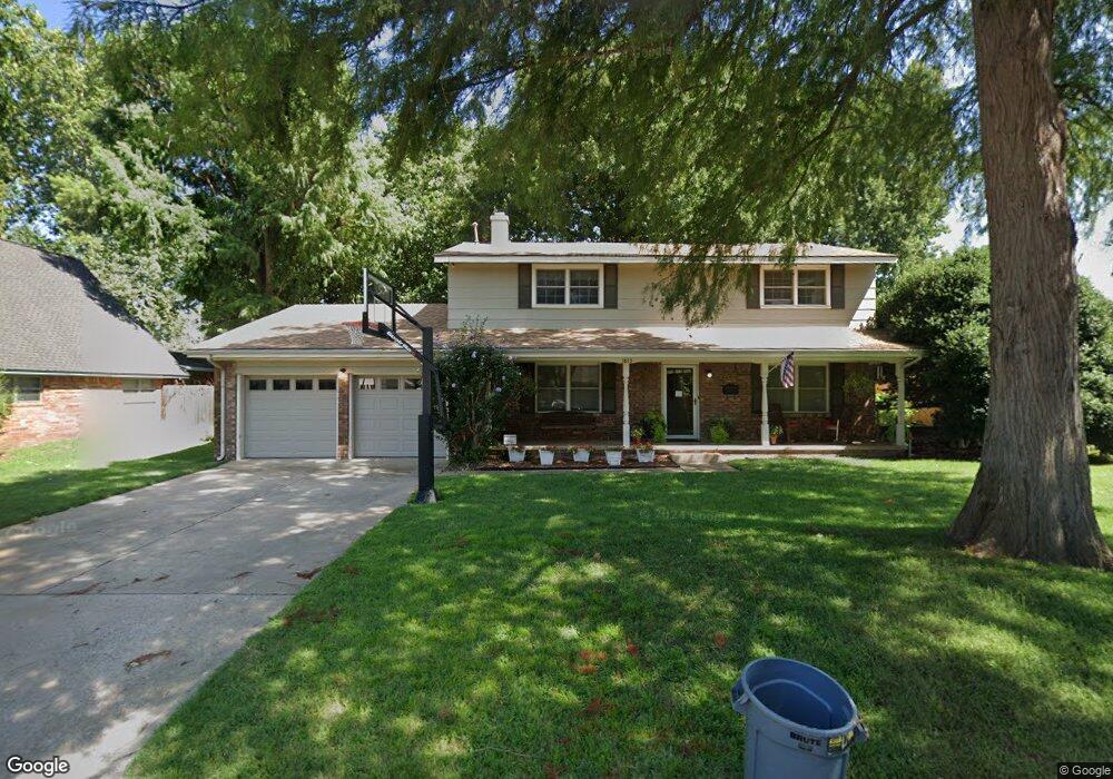
1815 Peter Pan St Norman, OK 73072
Southwest Norman NeighborhoodEstimated Value: $297,029 - $370,000
4
Beds
3
Baths
2,308
Sq Ft
$142/Sq Ft
Est. Value
About This Home
This home is located at 1815 Peter Pan St, Norman, OK 73072 and is currently estimated at $328,257, approximately $142 per square foot. 1815 Peter Pan St is a home located in Cleveland County with nearby schools including Monroe Elementary School, Alcott Middle School, and Norman High School.
Ownership History
Date
Name
Owned For
Owner Type
Purchase Details
Closed on
Dec 6, 2010
Sold by
Osuna Kevin R and Osuna Julianna
Bought by
Osuna Kevin R and Osuna Julianna
Current Estimated Value
Home Financials for this Owner
Home Financials are based on the most recent Mortgage that was taken out on this home.
Original Mortgage
$168,000
Outstanding Balance
$3,757
Interest Rate
4.22%
Mortgage Type
New Conventional
Estimated Equity
$324,500
Purchase Details
Closed on
Jul 19, 2004
Sold by
Tauxe Irene
Bought by
Harris Benjamin
Create a Home Valuation Report for This Property
The Home Valuation Report is an in-depth analysis detailing your home's value as well as a comparison with similar homes in the area
Home Values in the Area
Average Home Value in this Area
Purchase History
| Date | Buyer | Sale Price | Title Company |
|---|---|---|---|
| Osuna Kevin R | -- | None Available | |
| Harris Benjamin | $162,500 | -- |
Source: Public Records
Mortgage History
| Date | Status | Borrower | Loan Amount |
|---|---|---|---|
| Open | Osuna Kevin R | $168,000 |
Source: Public Records
Tax History Compared to Growth
Tax History
| Year | Tax Paid | Tax Assessment Tax Assessment Total Assessment is a certain percentage of the fair market value that is determined by local assessors to be the total taxable value of land and additions on the property. | Land | Improvement |
|---|---|---|---|---|
| 2024 | $2,485 | $21,749 | $3,015 | $18,734 |
| 2023 | $2,416 | $21,116 | $3,136 | $17,980 |
| 2022 | $2,246 | $20,501 | $2,400 | $18,101 |
| 2021 | $2,367 | $20,501 | $2,400 | $18,101 |
| 2020 | $2,317 | $20,501 | $2,400 | $18,101 |
| 2019 | $2,356 | $20,501 | $2,400 | $18,101 |
| 2018 | $2,285 | $20,501 | $2,400 | $18,101 |
| 2017 | $2,311 | $20,501 | $0 | $0 |
| 2016 | $2,349 | $20,501 | $2,400 | $18,101 |
| 2015 | $2,281 | $20,529 | $1,454 | $19,075 |
| 2014 | $2,303 | $20,529 | $1,454 | $19,075 |
Source: Public Records
Map
Nearby Homes
- 1744 Westbrooke Terrace
- 1830 Rolling Hills St
- 1711 Westbrooke Terrace
- 1447 Homeland Ave
- 2521 McGee Dr Unit 5
- 2504 O J Talley Cir
- 2101 Riverside Dr
- 1333 Homeland Ave
- 2502 Cypress Ave
- 2301 Mckown Dr
- 1301 24th Ave SW Unit 1305
- 1335 Spruce Dr
- 2805 Belknap Ave Unit 2807
- 1524 Wilshire Ave
- 3001 Marigold Trail
- 2720 Cypress Ave
- 2812 Shoreridge Ave Unit 2814
- 2812 Shoreridge Ave Unit 2814, 2812
- 2022 Morning Dew Trail
- 1124 Westbrooke Terrace
- 1809 Peter Pan St
- 1821 Peter Pan St
- 1814 Aladdin St
- 1803 Peter Pan St
- 1820 Aladdin St
- 1812 Peter Pan St
- 1808 Aladdin St
- 1818 Peter Pan St
- 1826 Aladdin St
- 1806 Peter Pan St
- 1827 Peter Pan St
- 1900 Aladdin St
- 1802 Aladdin St
- 1800 Peter Pan St
- 1907 Peter Pan St
- 1902 Peter Pan St
- 1908 Peter Pan St
- 1906 Aladdin St
- 1813 Aladdin St
- 1805 Aladdin St