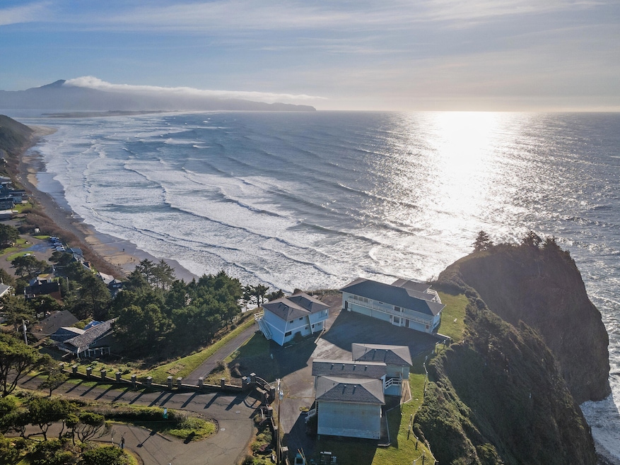
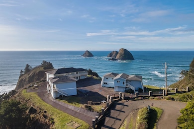
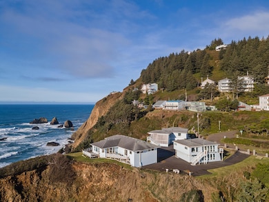
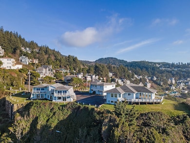

1816 Maxwell Mountain Rd Oceanside, OR 97134
Estimated payment $16,062/month
About This Lot
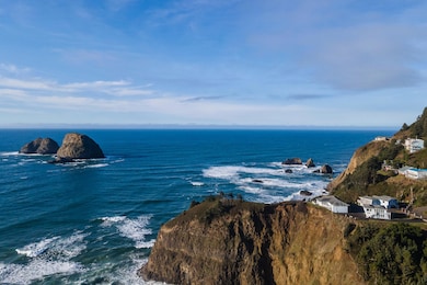
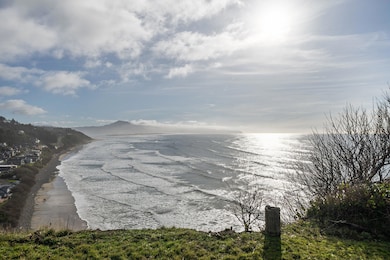
Once in a lifetime opportunity to own one of the most dramatic and recognizable oceanfront properties on the entire Oregon Coast. This 1.04-acre, gated estate is perched on a headland overlooking the Three Arch National Wildlife Refuge, the west coast's first wildlife preserve. Spectacular 250-degree ocean views surround the property. Potential for further division. Ideal site for private estate, hotel or high-density residential development. A true legacy property and the undisputed crown jewel of Oceanside! Updated geo report, topographic surveys and traffic/parking studies on file. Current structures in various states of repair.
Property Details
Property Type
- Land
Est. Annual Taxes
- $17,087
Lot Details
- 1.04 Acre Lot
- Ocean Front
- Level Lot
- Property is zoned ROS/R3
Utilities
- Electric Water Heater
- Phone Available
- Cable TV Available
Map
Home Values in the Area
Average Home Value in this Area
Tax History
| Year | Tax Paid | Tax Assessment Tax Assessment Total Assessment is a certain percentage of the fair market value that is determined by local assessors to be the total taxable value of land and additions on the property. | Land | Improvement |
|---|---|---|---|---|
| 2024 | $17,087 | $1,357,470 | $1,100,580 | $256,890 |
| 2023 | $17,021 | $1,317,940 | $1,068,530 | $249,410 |
| 2022 | $16,544 | $1,279,560 | $1,037,410 | $242,150 |
| 2021 | $15,527 | $1,242,300 | $1,007,200 | $235,100 |
| 2020 | $15,284 | $1,209,110 | $732,610 | $476,500 |
| 2019 | $15,318 | $1,173,900 | $711,280 | $462,620 |
| 2018 | $15,036 | $1,139,718 | $690,572 | $449,146 |
| 2017 | $18,020 | $1,361,880 | $407,450 | $954,430 |
| 2016 | $17,349 | $1,322,220 | $395,580 | $926,640 |
| 2015 | $17,221 | $1,283,710 | $384,060 | $899,650 |
| 2014 | $17,293 | $1,246,330 | $372,870 | $873,460 |
| 2013 | -- | $1,210,030 | $362,010 | $848,020 |
Property History
| Date | Event | Price | List to Sale | Price per Sq Ft |
|---|---|---|---|---|
| 06/23/2025 06/23/25 | Price Changed | $2,750,000 | -24.7% | $357 / Sq Ft |
| 02/07/2025 02/07/25 | For Sale | $3,650,000 | -- | $474 / Sq Ft |
Purchase History
| Date | Type | Sale Price | Title Company |
|---|---|---|---|
| Interfamily Deed Transfer | -- | None Available | |
| Warranty Deed | $1,179,000 | First American |
Source: Tillamook Board of REALTORS®
MLS Number: 25-41
APN: R0193999
Disclaimer: Certain information contained herein is derived from information provided by parties other than Homes.com. All information provided is deemed reliable, but is not guaranteed to be accurate and should be independently verified.
![]() IDX information is provided exclusively for personal, non-commercial use, and may not be used for any purpose other than to identify prospective properties consumers may be interested in purchasing. Information is deemed reliable but not guaranteed.
IDX information is provided exclusively for personal, non-commercial use, and may not be used for any purpose other than to identify prospective properties consumers may be interested in purchasing. Information is deemed reliable but not guaranteed.
- 0 Chinook Ave Unit 5 166135339
- 0 Chinook Ave Unit Tax Lot 11801 24-606
- 0 Chinook Ave Unit TL11801 24464111
- 0 Lot 5 of Block 15 Chinook Ave Unit 12500 25-436
- 1655 Portland Ave
- 5430 Grand Ave
- 0 Norwester Rd Unit 800 647374654
- 1820 Maxwell Mountain Rd
- 1505 Pacific Ave
- 1495 Pacific Ave
- 1555 Hillcrest Ave
- 0 Tl 3900 S Castle Ln
- TL#3900 S Castle Ln
- 0 Castle Dr Unit TL 16500 25-422
- 0 Castle Dr Unit TL16500 748763023
- 0 Pinewood W Unit 6 25-162
- 0 Pinewood Ln Unit 561093735
- 900 Bearberry Ln
- 0 Hillsdale St W Unit 411915636
- 0 Hillsdale St W Unit 388388008
