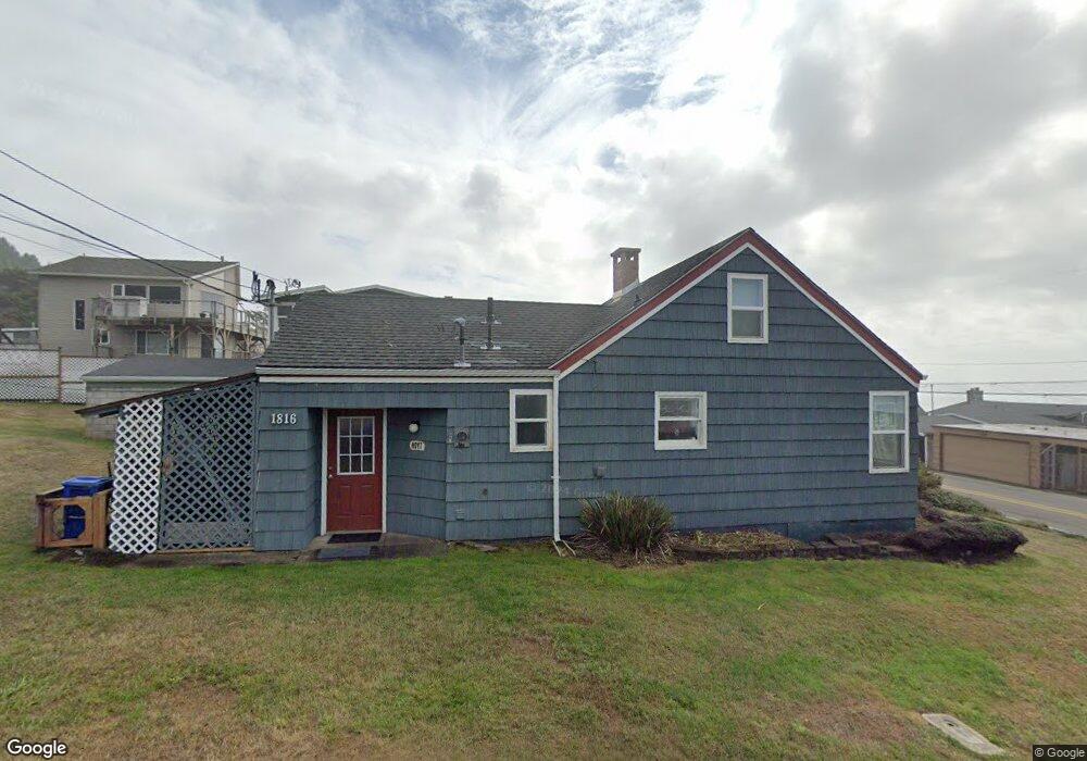
1816 NE 72nd St Lincoln City, OR 97367
Estimated Value: $386,000 - $619,000
2
Beds
3
Baths
1,025
Sq Ft
$487/Sq Ft
Est. Value
About This Home
This home is located at 1816 NE 72nd St, Lincoln City, OR 97367 and is currently estimated at $499,394, approximately $487 per square foot. 1816 NE 72nd St is a home located in Lincoln County with nearby schools including Oceanlake Elementary School, Taft Elementary School, and Taft High School.
Ownership History
Date
Name
Owned For
Owner Type
Purchase Details
Closed on
Jul 3, 2024
Sold by
George W Hoyt Trust and Hoyt Colleen
Bought by
Hoyt Mark Cameron and Hoyt Brian Scott
Current Estimated Value
Purchase Details
Closed on
Aug 27, 2008
Sold by
Hanson Martha Roean
Bought by
Hanson Living Trust
Purchase Details
Closed on
Jun 3, 2008
Sold by
Burns Richard R
Bought by
Hoyt Mark C and Hoyt Brian S
Create a Home Valuation Report for This Property
The Home Valuation Report is an in-depth analysis detailing your home's value as well as a comparison with similar homes in the area
Home Values in the Area
Average Home Value in this Area
Purchase History
| Date | Buyer | Sale Price | Title Company |
|---|---|---|---|
| Hoyt Mark Cameron | -- | None Listed On Document | |
| Hanson Living Trust | -- | None Available | |
| Hoyt Mark C | -- | None Available | |
| Burns Family Revocable Trust | -- | None Available |
Source: Public Records
Tax History Compared to Growth
Tax History
| Year | Tax Paid | Tax Assessment Tax Assessment Total Assessment is a certain percentage of the fair market value that is determined by local assessors to be the total taxable value of land and additions on the property. | Land | Improvement |
|---|---|---|---|---|
| 2024 | $3,897 | $230,340 | -- | -- |
| 2023 | $3,790 | $223,640 | $0 | $0 |
| 2022 | $3,685 | $217,130 | $0 | $0 |
| 2021 | $3,483 | $210,810 | $0 | $0 |
| 2020 | $3,382 | $204,670 | $0 | $0 |
| 2019 | $3,251 | $197,730 | $0 | $0 |
| 2018 | $3,302 | $199,490 | $0 | $0 |
| 2017 | $3,209 | $196,740 | $0 | $0 |
| 2016 | $3,067 | $192,330 | $0 | $0 |
| 2015 | $3,004 | $186,730 | $0 | $0 |
| 2014 | $2,521 | $166,290 | $0 | $0 |
| 2013 | -- | $179,720 | $0 | $0 |
Source: Public Records
Map
Nearby Homes
- 7131 NW Logan Rd
- 7101 NW Logan Rd
- 1924 NE 71st St
- 6937 NW Logan Rd
- 1906 NE 69th St
- VL NE Neptune Dr
- 1850 NE 68th St
- 1910 NE 68th St
- 1851 NE 67th St
- 7495 NE Neptune Dr
- 6604 NE Logan Rd
- 6538 NE Logan Rd
- TL3200 NE Williams Ct
- 6421 NE Port Dr
- TL10400 NE Sal La Sea Dr
- 0 NE 64th Dr Unit TL12000 443875862
- 6310 NE Logan Rd
- TL 12000 NE 64th Dr
- 6200 Blk NE Port Drive Tl 9200
- 6225 NW Logan Rd
- 7111 Logan NW
- 1819 NE 72nd St
- 7130 NE Logan Rd
- 7106 NE Logan Rd
- 1833 NE 71st St
- 1847 NE 71st St
- 7145 NW Logan Rd
- 7228 NE Logan Rd
- 7123 NW Logan Rd
- 7123 NE Logan Rd
- 7207 NW Logan Rd
- 7228 NW Logan Rd
- 1825 NE 72nd St
- 1828 NE 72nd St
- 1857 NE 71st St
- 1900 Blk NE 71st St
- 7236 NE Logan Rd
- 1915 NE 71st St
- 7101 Logan Dr