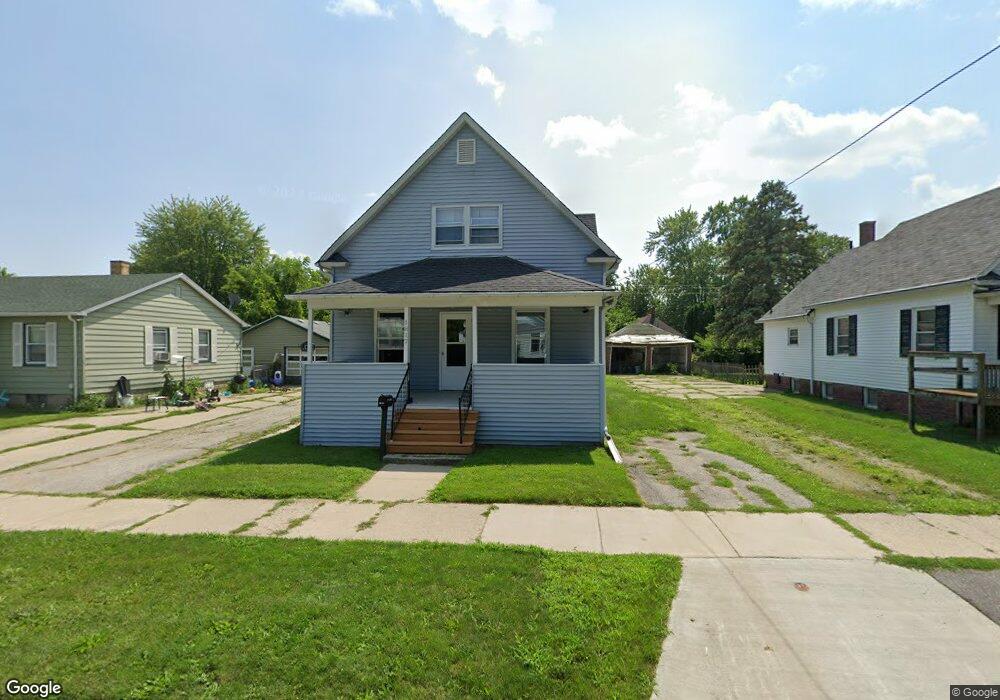
1817 Burnham St Saginaw, MI 48602
Southwest NeighborhoodEstimated Value: $63,000 - $83,420
4
Beds
1
Bath
1,492
Sq Ft
$51/Sq Ft
Est. Value
About This Home
This home is located at 1817 Burnham St, Saginaw, MI 48602 and is currently estimated at $75,355, approximately $50 per square foot. 1817 Burnham St is a home located in Saginaw County with nearby schools including Merrill Park Elementary School, Thompson Middle School, and Arthur Hill High School.
Ownership History
Date
Name
Owned For
Owner Type
Purchase Details
Closed on
Oct 28, 2013
Sold by
Juarez Christine and Juarez David
Bought by
Ovalle Edward
Current Estimated Value
Purchase Details
Closed on
Oct 14, 2002
Sold by
Defrain Kenneth B and Defrain Marian
Bought by
Defrain Scott R
Purchase Details
Closed on
Jun 6, 2001
Sold by
Defrain Kenneth B and Defrain Marian
Bought by
Defrain Kenneth B and Defrain Marian
Purchase Details
Closed on
Oct 29, 1986
Sold by
Nasset Brenda S
Bought by
Nasset Nels A
Purchase Details
Closed on
May 1, 1984
Sold by
Marshall Paul A and Marshall Pamela
Bought by
Nasset Nels A and Nasset Brenda S
Create a Home Valuation Report for This Property
The Home Valuation Report is an in-depth analysis detailing your home's value as well as a comparison with similar homes in the area
Home Values in the Area
Average Home Value in this Area
Purchase History
| Date | Buyer | Sale Price | Title Company |
|---|---|---|---|
| Ovalle Edward | -- | -- | |
| Defrain Scott R | -- | -- | |
| Defrain Kenneth B | -- | -- | |
| Nasset Nels A | -- | -- | |
| Nasset Nels A | $24,900 | -- |
Source: Public Records
Tax History Compared to Growth
Tax History
| Year | Tax Paid | Tax Assessment Tax Assessment Total Assessment is a certain percentage of the fair market value that is determined by local assessors to be the total taxable value of land and additions on the property. | Land | Improvement |
|---|---|---|---|---|
| 2025 | $1,206 | $33,700 | $0 | $0 |
| 2024 | $915 | $29,700 | $0 | $0 |
| 2023 | $882 | $25,600 | $0 | $0 |
| 2022 | $1,110 | $21,200 | $0 | $0 |
| 2021 | $1,035 | $19,600 | $0 | $0 |
| 2020 | $904 | $20,100 | $0 | $0 |
| 2019 | $915 | $18,100 | $700 | $17,400 |
| 2018 | $713 | $19,735 | $0 | $0 |
| 2017 | $877 | $18,850 | $0 | $0 |
| 2016 | $869 | $18,691 | $0 | $0 |
| 2014 | -- | $19,695 | $0 | $19,022 |
| 2013 | -- | $20,591 | $0 | $0 |
Source: Public Records
Map
Nearby Homes
- 1817 Ring St
- 1823 Ring St
- 1924 Wood St
- 1914 Joslin St
- 1916 Joslin St
- 1843 Kendrick St
- 1306 S Wheeler St
- 1725 Kendrick St
- 1918 Stanley St
- 1716 Maple St
- 1756 Jordan St
- 1830 Jordan St
- 1652 Stanley St
- 2300 Jerome St
- 1919 Grout St
- 2116 Wood St
- 1830 Zauel St
- 2116 W Michigan Ave
- 2219 S Michigan Ave
- 819 Grove St
- 1813 Burnham St
- 1823 Burnham St
- 1807 Burnham St
- 1803 Burnham St
- 1806 Burnham St
- 1816 Burnham St
- 1822 Burnham St
- 1827 Burnham St
- 1812 Burnham St
- 1822 Wood St
- 1833 Burnham St
- 1812 Wood St
- 1757 Burnham St
- 1802 Wood St
- 1802 Burnham St
- 1818 Wood St
- 1839 Burnham St
- 1806 Wood St
- 1826 Wood St
- 1828 Burnham St