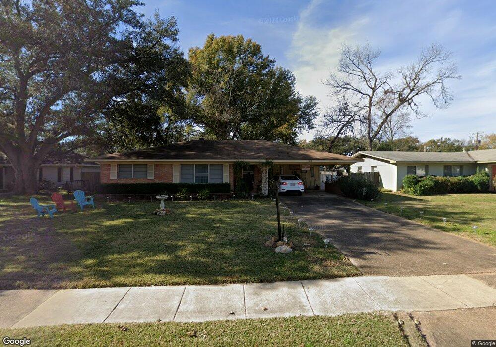
1818 Captain Shreve Dr Shreveport, LA 71105
Broadmoor/Anderson Island/Shreve Isle NeighborhoodEstimated Value: $140,000 - $193,179
3
Beds
1
Bath
1,620
Sq Ft
$103/Sq Ft
Est. Value
About This Home
This home is located at 1818 Captain Shreve Dr, Shreveport, LA 71105 and is currently estimated at $167,045, approximately $103 per square foot. 1818 Captain Shreve Dr is a home located in Caddo Parish with nearby schools including Fairfield Magnet School, Judson Fundamental Elementary School, and Eden Gardens Fundamental Elementary School.
Ownership History
Date
Name
Owned For
Owner Type
Purchase Details
Closed on
Jan 28, 2025
Sold by
Munyon Linda O
Bought by
Hancock Susan B
Current Estimated Value
Home Financials for this Owner
Home Financials are based on the most recent Mortgage that was taken out on this home.
Original Mortgage
$162,011
Outstanding Balance
$161,012
Interest Rate
6.72%
Mortgage Type
New Conventional
Estimated Equity
$6,033
Purchase Details
Closed on
Aug 26, 2022
Sold by
Kay Eddins Brenda
Bought by
Munyon Linda O
Purchase Details
Closed on
Jun 10, 2021
Sold by
Eddins Jo Bevely
Bought by
Eddins Brenda Kay
Purchase Details
Closed on
Sep 27, 2007
Sold by
Hansen Duane T and Hansen Hsleta Bolton
Bought by
Eddins Jo L
Create a Home Valuation Report for This Property
The Home Valuation Report is an in-depth analysis detailing your home's value as well as a comparison with similar homes in the area
Home Values in the Area
Average Home Value in this Area
Purchase History
| Date | Buyer | Sale Price | Title Company |
|---|---|---|---|
| Hancock Susan B | $165,000 | None Listed On Document | |
| Munyon Linda O | $160,000 | None Listed On Document | |
| Eddins Brenda Kay | -- | None Available | |
| Eddins Jo L | $120,000 | None Available |
Source: Public Records
Mortgage History
| Date | Status | Borrower | Loan Amount |
|---|---|---|---|
| Open | Hancock Susan B | $162,011 |
Source: Public Records
Tax History Compared to Growth
Tax History
| Year | Tax Paid | Tax Assessment Tax Assessment Total Assessment is a certain percentage of the fair market value that is determined by local assessors to be the total taxable value of land and additions on the property. | Land | Improvement |
|---|---|---|---|---|
| 2024 | $2,620 | $16,805 | $2,936 | $13,869 |
| 2023 | $2,506 | $15,720 | $2,797 | $12,923 |
| 2022 | $2,506 | $15,720 | $2,797 | $12,923 |
| 2021 | $2,285 | $14,556 | $2,797 | $11,759 |
| 2020 | $1,884 | $12,000 | $2,306 | $9,694 |
| 2019 | $1,941 | $12,000 | $2,410 | $9,590 |
| 2018 | $579 | $12,000 | $2,540 | $9,460 |
| 2017 | $1,971 | $12,000 | $2,540 | $9,460 |
| 2015 | $583 | $12,000 | $2,540 | $9,460 |
| 2014 | $588 | $12,000 | $2,540 | $9,460 |
| 2013 | -- | $12,000 | $2,540 | $9,460 |
Source: Public Records
Map
Nearby Homes
- 1810 Captain Shreve Dr
- 1919 Audubon Place
- 1923 Bermuda St
- 2005 E Kings Hwy
- 2013 E Kings Hwy
- 1615 Captain Shreve Dr
- 1836 Bryan Place
- 1601 Captain Shreve Dr
- 2045 Horton Ave
- 2049 River Rd
- 142 Lynn Ave
- 636 Pelican Place
- 147 Pennsylvania Ave
- 129 Carrollton Ave
- 153 Carrollton Ave
- 1419 Audubon Place
- 156 Charles Ave
- 502 Mockingbird Ln
- 106 Leo Ave
- 174 Carrollton Ave
- 1814 Captain Shreve Dr
- 1822 Captain Shreve Dr
- 1819 Audubon Place
- 1902 Captain Shreve Dr
- 1823 Audubon Place
- 402 Locust St
- 1815 Audubon Place
- 1906 Captain Shreve Dr
- 1817 Captain Shreve Dr
- 1901 Audubon Place
- 1811 Captain Shreve Dr
- 1809 Audubon Place
- 408 Locust St
- 1802 Captain Shreve Dr
- 1910 Captain Shreve Dr
- 1905 Audubon Place
- 1905 Audubon Place
- 1807 Captain Shreve Dr
- 1805 Audubon Place
- 412 Locust St