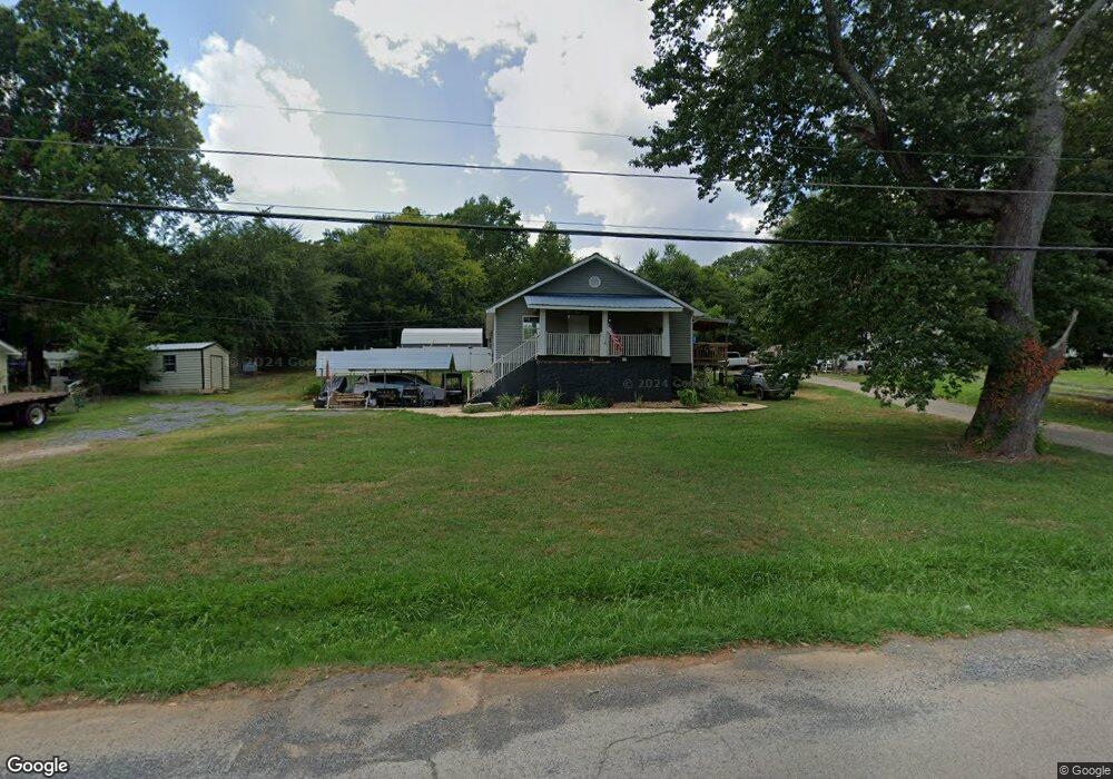
1818 Guy St Dalton, GA 30720
Estimated Value: $155,473 - $210,000
Studio
2
Baths
1,344
Sq Ft
$136/Sq Ft
Est. Value
About This Home
This home is located at 1818 Guy St, Dalton, GA 30720 and is currently estimated at $182,118, approximately $135 per square foot. 1818 Guy St is a home located in Whitfield County with nearby schools including Dug Gap Elementary School, Valley Point Middle School, and Southeast Whitfield County High School.
Ownership History
Date
Name
Owned For
Owner Type
Purchase Details
Closed on
Oct 19, 2021
Sold by
Dyer Susan R
Bought by
Dyer Susan R and Swavely Brett Holiday
Current Estimated Value
Home Financials for this Owner
Home Financials are based on the most recent Mortgage that was taken out on this home.
Original Mortgage
$72,000
Outstanding Balance
$40,903
Interest Rate
2.8%
Mortgage Type
New Conventional
Estimated Equity
$141,215
Purchase Details
Closed on
Dec 1, 1992
Bought by
Dyer Susan R
Create a Home Valuation Report for This Property
The Home Valuation Report is an in-depth analysis detailing your home's value as well as a comparison with similar homes in the area
Purchase History
| Date | Buyer | Sale Price | Title Company |
|---|---|---|---|
| Dyer Susan R | -- | None Listed On Document | |
| Dyer Susan R | -- | None Listed On Document | |
| Dyer Susan R | -- | -- | |
| Dyer Susan R | $35,000 | -- |
Source: Public Records
Mortgage History
| Date | Status | Borrower | Loan Amount |
|---|---|---|---|
| Open | Dyer Susan R | $72,000 | |
| Closed | Dyer Susan R | $72,000 |
Source: Public Records
Tax History
| Year | Tax Paid | Tax Assessment Tax Assessment Total Assessment is a certain percentage of the fair market value that is determined by local assessors to be the total taxable value of land and additions on the property. | Land | Improvement |
|---|---|---|---|---|
| 2025 | $1,177 | $59,225 | $8,000 | $51,225 |
| 2024 | $1,177 | $59,225 | $8,000 | $51,225 |
| 2023 | $932 | $37,480 | $3,900 | $33,580 |
| 2022 | $582 | $28,302 | $3,900 | $24,402 |
| 2021 | $583 | $28,302 | $3,900 | $24,402 |
| 2020 | $591 | $28,302 | $3,900 | $24,402 |
| 2019 | $595 | $28,302 | $3,900 | $24,402 |
| 2018 | $599 | $28,302 | $3,900 | $24,402 |
| 2017 | $599 | $28,302 | $3,900 | $24,402 |
| 2016 | $544 | $26,814 | $4,620 | $22,194 |
| 2014 | $523 | $26,814 | $4,620 | $22,194 |
| 2013 | -- | $26,813 | $4,620 | $22,193 |
Source: Public Records
Map
Nearby Homes
- 1802 Malone Dr
- 1800 Malone Dr
- 440 Florence Ave
- 439 Florence Ave
- 450 Florence Ave
- 1632 Rio Vista Dr
- 1541 Threadmill Rd
- 1709 Needham Dr
- 3012 E Brookhaven Cir
- 3008 E Brookhaven Cir
- 1508 Braiden Rd
- 1301 Swann Dr
- 0 Horizon Ct Unit 130497
- 0 Horizon Ct Unit 130499
- 0 Horizon Ct Unit 130479
- 0 Horizon Ct Unit 130477
- 0 Horizon Ct Unit 130478
- 0 Horizon Ct Unit 130496
- 0 Horizon Ct Unit 130498
- 1609 Ryman Ridge Rd
- 1816 Guy St
- 1820 Guy St
- 1826 Guy St
- 114 Chastain Way
- 1828 Guy St
- 1820 Dejournette Dr
- 1818 Dejournette Dr
- 304 Florence Ave
- 310 Florence Ave
- 1816 Dejournette Dr
- 1827 Dejournette Dr
- 1814 Dejournette Dr
- 312 Florence Ave
- 1808 Guy St
- 1815 Malone Dr
- 1809 Guy St
- 1809 Guy St
- 1812 Dejournette Dr
- 1811 Malone Dr
- 301 Florence Ave
Your Personal Tour Guide
Ask me questions while you tour the home.