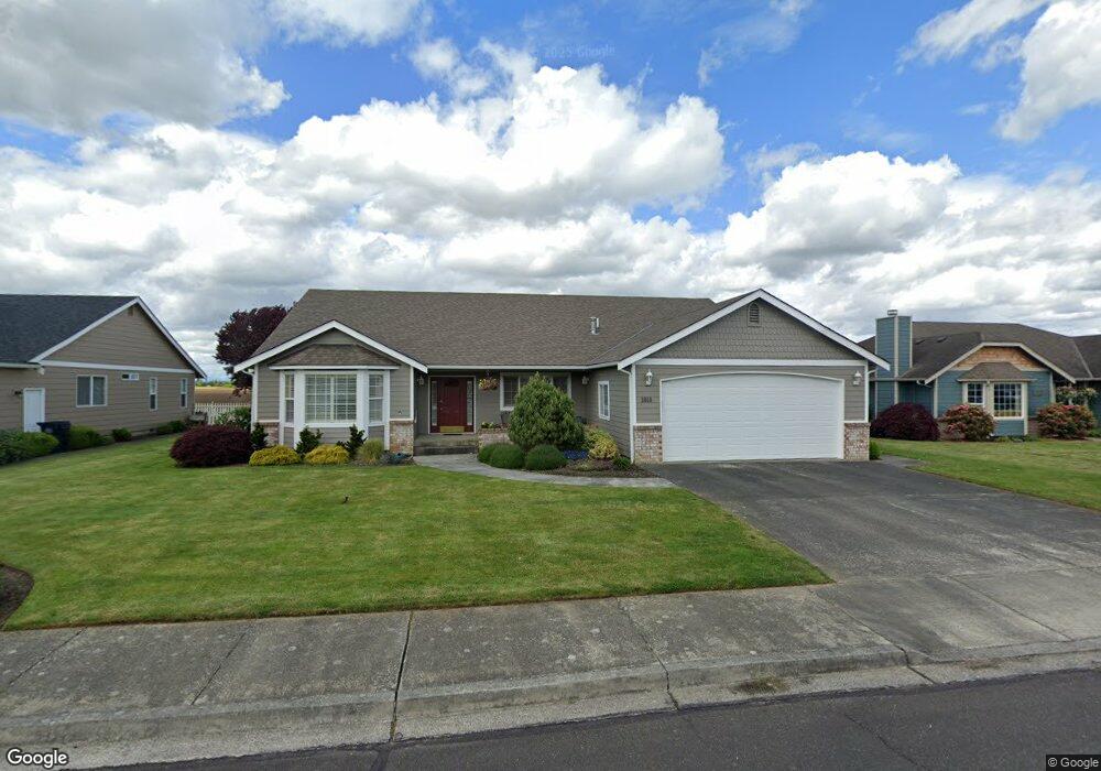
1818 Pine Cir Lynden, WA 98264
Estimated Value: $668,981 - $731,000
4
Beds
2
Baths
2,229
Sq Ft
$315/Sq Ft
Est. Value
About This Home
This home is located at 1818 Pine Cir, Lynden, WA 98264 and is currently estimated at $701,495, approximately $314 per square foot. 1818 Pine Cir is a home located in Whatcom County with nearby schools including Lynden High School, Lynden Christian School, and Lynden Christian Schools: Administration.
Ownership History
Date
Name
Owned For
Owner Type
Purchase Details
Closed on
Jun 21, 2017
Sold by
Marr James E and Marr Judith G
Bought by
Marr James E and Marr Judith G
Current Estimated Value
Purchase Details
Closed on
Jun 2, 2004
Sold by
Home Peter W and Home Diane F
Bought by
Marr James E and Marr Judith G
Home Financials for this Owner
Home Financials are based on the most recent Mortgage that was taken out on this home.
Original Mortgage
$228,000
Outstanding Balance
$109,014
Interest Rate
6%
Mortgage Type
Purchase Money Mortgage
Estimated Equity
$592,481
Purchase Details
Closed on
Apr 8, 2003
Sold by
Strom Warren R and Strom Kristy
Bought by
Horne Peter W and Horne Dianne F
Home Financials for this Owner
Home Financials are based on the most recent Mortgage that was taken out on this home.
Original Mortgage
$176,000
Interest Rate
5.73%
Mortgage Type
Purchase Money Mortgage
Create a Home Valuation Report for This Property
The Home Valuation Report is an in-depth analysis detailing your home's value as well as a comparison with similar homes in the area
Home Values in the Area
Average Home Value in this Area
Purchase History
| Date | Buyer | Sale Price | Title Company |
|---|---|---|---|
| Marr James E | -- | None Available | |
| Marr James E | $285,000 | Chicago Title Insurance | |
| Horne Peter W | $255,947 | Chicago Title Insurance |
Source: Public Records
Mortgage History
| Date | Status | Borrower | Loan Amount |
|---|---|---|---|
| Open | Marr James E | $228,000 | |
| Previous Owner | Horne Peter W | $176,000 |
Source: Public Records
Tax History
| Year | Tax Paid | Tax Assessment Tax Assessment Total Assessment is a certain percentage of the fair market value that is determined by local assessors to be the total taxable value of land and additions on the property. | Land | Improvement |
|---|---|---|---|---|
| 2025 | $4,901 | $665,239 | $272,825 | $392,414 |
| 2024 | $4,589 | $647,051 | $242,500 | $404,551 |
| 2023 | $4,589 | $638,991 | $250,000 | $388,991 |
| 2022 | $4,018 | $527,820 | $127,711 | $400,109 |
| 2021 | $3,941 | $436,210 | $105,545 | $330,665 |
| 2020 | $3,452 | $389,483 | $94,239 | $295,244 |
| 2019 | $3,071 | $357,168 | $86,527 | $270,641 |
| 2018 | $3,357 | $325,769 | $78,823 | $246,946 |
| 2017 | $3,073 | $292,405 | $70,750 | $221,655 |
| 2016 | $2,893 | $284,718 | $66,000 | $218,718 |
| 2015 | $2,564 | $266,597 | $63,480 | $203,117 |
| 2014 | -- | $257,568 | $61,320 | $196,248 |
| 2013 | -- | $256,248 | $60,000 | $196,248 |
Source: Public Records
Map
Nearby Homes
- 8424 Double Ditch Rd
- 702 Woodview Ct
- 801 19th St
- 108 Fairside Dr Unit 1
- 2108 Main St
- 1656 Liberty St Unit 101
- 1884 Front St Unit B
- 1884 Front St
- 1884 Front St Unit A
- 902 Captain Bay Ct
- 816 Cedar Dr
- 1882 Front St Unit B302
- 805 Cedar Dr
- 7008 Guide Meridian Rd
- 735 Ivy St
- 410 10th St
- 2010 Front St Unit 33
- 1739 Emerald Way
- 1717 E St
- 1416 Front St
Your Personal Tour Guide
Ask me questions while you tour the home.