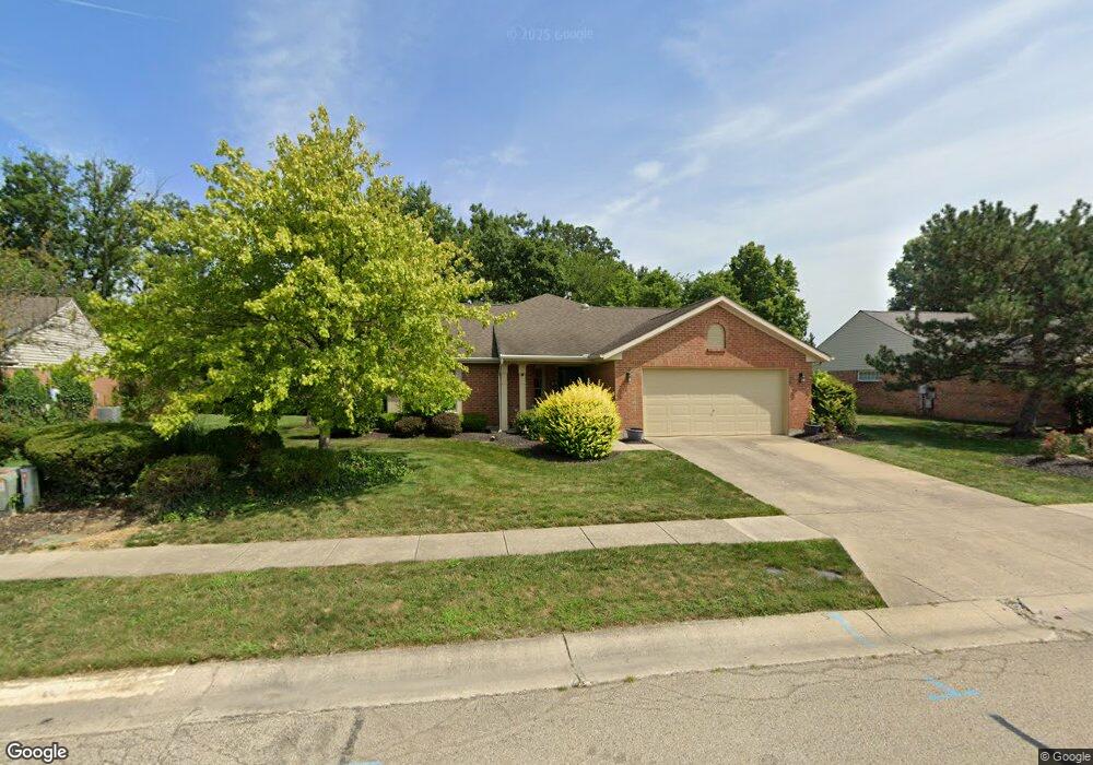
1819 Brandonhall Dr Miamisburg, OH 45342
Estimated Value: $271,000 - $310,000
3
Beds
2
Baths
1,832
Sq Ft
$164/Sq Ft
Est. Value
About This Home
This home is located at 1819 Brandonhall Dr, Miamisburg, OH 45342 and is currently estimated at $300,226, approximately $163 per square foot. 1819 Brandonhall Dr is a home located in Montgomery County with nearby schools including Miamisburg High School and Bethel Baptist School.
Ownership History
Date
Name
Owned For
Owner Type
Purchase Details
Closed on
Dec 17, 2015
Sold by
Schultz Paul T
Bought by
Schultz Paul T Tr
Current Estimated Value
Home Financials for this Owner
Home Financials are based on the most recent Mortgage that was taken out on this home.
Interest Rate
3.97%
Purchase Details
Closed on
Sep 22, 1999
Sold by
Schultz Paul T and Schultz Loueda M
Bought by
Schultz Paul T and Schultz Loueda M
Purchase Details
Closed on
Aug 1, 1994
Sold by
Brandonhall Development Inc
Bought by
Schultz Paul T and Schultz Loueda M
Create a Home Valuation Report for This Property
The Home Valuation Report is an in-depth analysis detailing your home's value as well as a comparison with similar homes in the area
Home Values in the Area
Average Home Value in this Area
Purchase History
| Date | Buyer | Sale Price | Title Company |
|---|---|---|---|
| Schultz Paul T Tr | -- | -- | |
| Schultz Paul T | -- | -- | |
| Schultz Paul T | -- | -- |
Source: Public Records
Mortgage History
| Date | Status | Borrower | Loan Amount |
|---|---|---|---|
| Closed | Schultz Paul T Tr | -- |
Source: Public Records
Tax History Compared to Growth
Tax History
| Year | Tax Paid | Tax Assessment Tax Assessment Total Assessment is a certain percentage of the fair market value that is determined by local assessors to be the total taxable value of land and additions on the property. | Land | Improvement |
|---|---|---|---|---|
| 2024 | $4,404 | $78,550 | $12,810 | $65,740 |
| 2023 | $4,404 | $78,550 | $12,810 | $65,740 |
| 2022 | $4,191 | $64,390 | $10,500 | $53,890 |
| 2021 | $3,707 | $64,390 | $10,500 | $53,890 |
| 2020 | $3,698 | $64,390 | $10,500 | $53,890 |
| 2019 | $3,771 | $60,820 | $10,500 | $50,320 |
| 2018 | $3,784 | $60,820 | $10,500 | $50,320 |
| 2017 | $3,758 | $60,820 | $10,500 | $50,320 |
| 2016 | $2,903 | $47,460 | $10,500 | $36,960 |
| 2015 | $2,847 | $47,460 | $10,500 | $36,960 |
| 2014 | $2,847 | $47,460 | $10,500 | $36,960 |
| 2012 | -- | $53,550 | $12,250 | $41,300 |
Source: Public Records
Map
Nearby Homes
- 1131 Castleton Ct
- 1734 Rosina Dr
- 1808 Burnside Dr
- 1035 Woods View Ct
- 902 Althea Dr
- 807 Dunaway St
- 2141 Rosina Dr
- 2127 Carrington Ln
- 766 Dunaway St
- 00 Benner Rd
- 1013 S Heincke Rd
- 736 Decker Dr
- 615 Burnside Dr
- 712 Decker Dr
- 628 Jamestown Dr
- 1045 S Linden Ave
- 1157 Bonniebrook Dr
- 1826 Ashley Dr
- 1786 Ashley Dr
- 811 Moon Ct
- 1825 Brandonhall Dr
- 1813 Brandonhall Dr
- 1831 Brandonhall Dr
- 1807 Brandonhall Dr
- 1812 Brandonhall Dr
- 1818 Brandonhall Dr
- 1824 Brandonhall Dr
- 1837 Brandonhall Dr
- 1806 Brandonhall Dr
- 1830 Brandonhall Dr
- 1829 Rosina Dr
- 1835 Rosina Dr
- 1843 Brandonhall Dr
- 1836 Brandonhall Dr
- 1823 Rosina Dr
- 1101 Castleton Ct
- 1841 Rosina Dr
- 1121 Castleton Ct
- 1817 Rosina Dr
- 1111 Castleton Ct