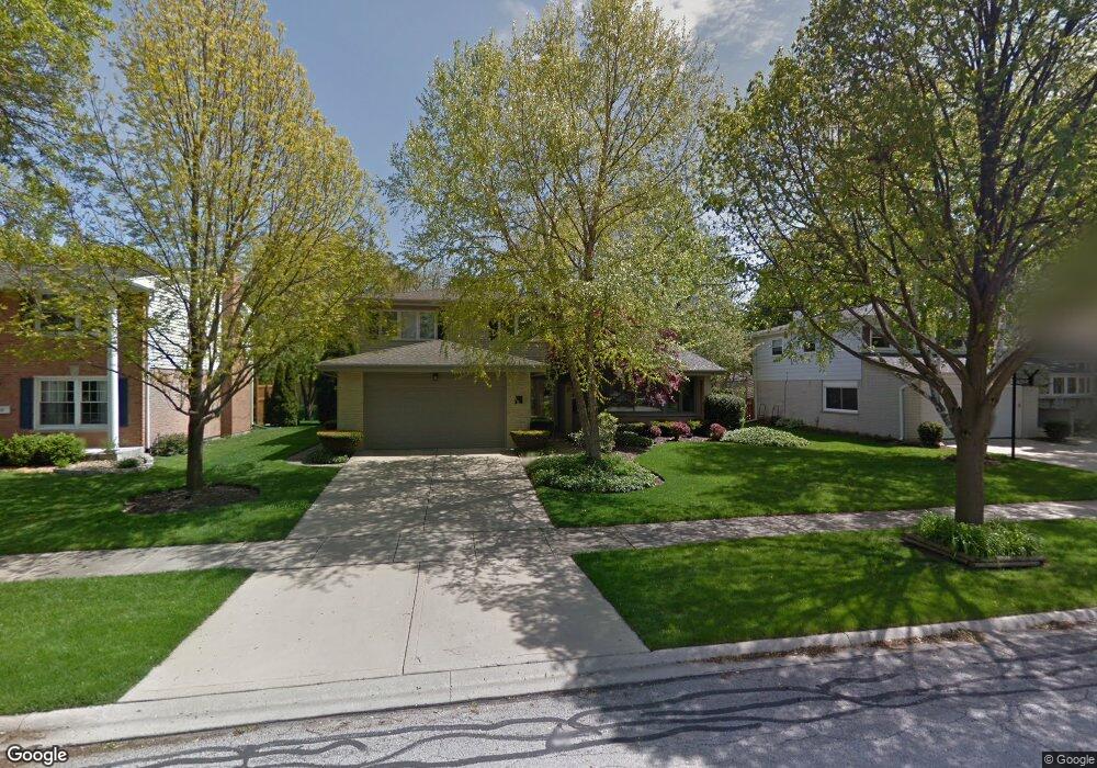
1819 N Rolling Ln Arlington Heights, IL 60004
Estimated Value: $558,000 - $673,000
4
Beds
3
Baths
2,541
Sq Ft
$236/Sq Ft
Est. Value
About This Home
This home is located at 1819 N Rolling Ln, Arlington Heights, IL 60004 and is currently estimated at $600,504, approximately $236 per square foot. 1819 N Rolling Ln is a home located in Cook County with nearby schools including Dwight D Eisenhower Elementary School, Anne Sullivan Elementary School, and Betsy Ross Elementary School.
Ownership History
Date
Name
Owned For
Owner Type
Purchase Details
Closed on
Jul 24, 2003
Sold by
Variano Jason A
Bought by
Variano Jason A and Jason A Variano Revocable Trust
Current Estimated Value
Purchase Details
Closed on
Jan 13, 2000
Sold by
Variano Vincent
Bought by
Variano Jason
Purchase Details
Closed on
Dec 26, 1996
Sold by
Variano Danielle
Bought by
Variano Jason and Variano Vincent
Create a Home Valuation Report for This Property
The Home Valuation Report is an in-depth analysis detailing your home's value as well as a comparison with similar homes in the area
Home Values in the Area
Average Home Value in this Area
Purchase History
| Date | Buyer | Sale Price | Title Company |
|---|---|---|---|
| Variano Jason A | -- | -- | |
| Variano Jason | $150,000 | Chicago Title Insurance Co | |
| Variano Jason | -- | -- |
Source: Public Records
Tax History Compared to Growth
Tax History
| Year | Tax Paid | Tax Assessment Tax Assessment Total Assessment is a certain percentage of the fair market value that is determined by local assessors to be the total taxable value of land and additions on the property. | Land | Improvement |
|---|---|---|---|---|
| 2024 | $9,782 | $39,101 | $9,625 | $29,476 |
| 2023 | $9,313 | $39,101 | $9,625 | $29,476 |
| 2022 | $9,313 | $39,101 | $9,625 | $29,476 |
| 2021 | $10,576 | $38,123 | $5,468 | $32,655 |
| 2020 | $10,362 | $38,123 | $5,468 | $32,655 |
| 2019 | $10,334 | $42,501 | $5,468 | $37,033 |
| 2018 | $9,738 | $36,879 | $4,812 | $32,067 |
| 2017 | $9,653 | $36,879 | $4,812 | $32,067 |
| 2016 | $9,228 | $36,879 | $4,812 | $32,067 |
| 2015 | $9,497 | $34,579 | $4,156 | $30,423 |
| 2014 | $9,389 | $34,579 | $4,156 | $30,423 |
| 2013 | $9,725 | $36,549 | $4,156 | $32,393 |
Source: Public Records
Map
Nearby Homes
- 1949 N Charter Point Dr Unit 1949
- 1912 N Coldspring Rd Unit 96
- 1961 N Coldspring Rd Unit 63
- 2026 N Stillwater Rd Unit 24
- 1956 N Silver Lake Rd
- 2611 E Radford Ct
- 307 Anne Ct
- 1519 E Arbor Ln
- 105 W Ridge Ave
- 11 W Palatine Rd
- 13 W Kenilworth Ave
- 1510 N Kendal Ct Unit 11510
- 802 Andover Ct
- 2315 E Olive St Unit 3G
- 2315 E Olive St Unit 2G
- 1424 E Jonquil Cir
- 1511 N Windsor Dr Unit 208
- 1215 N Waterman Ave Unit 3L
- 2143 E Peachtree Ln
- 1008 W Wildwood Dr
- 1815 N Rolling Ln
- 1823 N Rolling Ln
- 1814 N Dale Ave
- 1818 N Dale Ave
- 1811 N Rolling Ln
- 1827 N Rolling Ln
- 1810 N Dale Ave
- 2422 E Northwood Ct
- 1822 N Dale Ave
- 1807 N Rolling Ln
- 1806 N Dale Ave
- 1806 N Rolling Ln Unit 1
- 1829 N Rolling Ln
- 2415 E Michael Manor Ln
- 2418 E Northwood Ct
- 1826 N Dale Ave
- 2419 E Northwood Ct
- 1802 N Dale Ave
- 1803 N Rolling Ln
- 2411 E Michael Manor Ln