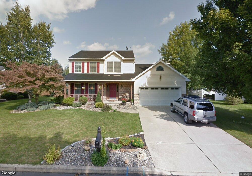
182 Aster St Nazareth, PA 18064
Estimated Value: $451,662 - $499,000
3
Beds
3
Baths
1,924
Sq Ft
$250/Sq Ft
Est. Value
About This Home
This home is located at 182 Aster St, Nazareth, PA 18064 and is currently estimated at $481,666, approximately $250 per square foot. 182 Aster St is a home located in Northampton County with nearby schools including Floyd R. Shafer Elementary School, Nazareth Area Middle School, and Nazareth Area High School.
Ownership History
Date
Name
Owned For
Owner Type
Purchase Details
Closed on
Feb 9, 2011
Sold by
Malitsis Lena A and Malitsis Spiro
Bought by
Malitsis Lena A and Malitsis Spiro
Current Estimated Value
Home Financials for this Owner
Home Financials are based on the most recent Mortgage that was taken out on this home.
Original Mortgage
$233,500
Outstanding Balance
$156,614
Interest Rate
4.83%
Mortgage Type
New Conventional
Estimated Equity
$325,052
Purchase Details
Closed on
May 29, 2007
Sold by
Kingsley John W
Bought by
Malitsis Spiro
Home Financials for this Owner
Home Financials are based on the most recent Mortgage that was taken out on this home.
Original Mortgage
$45,000
Interest Rate
5.95%
Mortgage Type
Future Advance Clause Open End Mortgage
Create a Home Valuation Report for This Property
The Home Valuation Report is an in-depth analysis detailing your home's value as well as a comparison with similar homes in the area
Home Values in the Area
Average Home Value in this Area
Purchase History
| Date | Buyer | Sale Price | Title Company |
|---|---|---|---|
| Malitsis Lena A | -- | None Available | |
| Malitsis Spiro | $300,000 | -- |
Source: Public Records
Mortgage History
| Date | Status | Borrower | Loan Amount |
|---|---|---|---|
| Open | Malitsis Lena A | $233,500 | |
| Closed | Malitsis Spiro | $45,000 | |
| Closed | Malitsis Spiro | $240,000 |
Source: Public Records
Tax History
| Year | Tax Paid | Tax Assessment Tax Assessment Total Assessment is a certain percentage of the fair market value that is determined by local assessors to be the total taxable value of land and additions on the property. | Land | Improvement |
|---|---|---|---|---|
| 2026 | $798 | $73,900 | $20,200 | $53,700 |
| 2025 | $798 | $73,900 | $20,200 | $53,700 |
| 2024 | $5,609 | $73,900 | $20,200 | $53,700 |
| 2023 | $5,557 | $73,900 | $20,200 | $53,700 |
| 2022 | $5,557 | $73,900 | $20,200 | $53,700 |
| 2021 | $5,552 | $73,900 | $20,200 | $53,700 |
| 2020 | $5,552 | $73,900 | $20,200 | $53,700 |
| 2019 | $5,423 | $73,900 | $20,200 | $53,700 |
| 2018 | $5,285 | $73,900 | $20,200 | $53,700 |
| 2017 | $5,157 | $73,900 | $20,200 | $53,700 |
| 2016 | -- | $73,900 | $20,200 | $53,700 |
| 2015 | -- | $73,900 | $20,200 | $53,700 |
| 2014 | -- | $73,900 | $20,200 | $53,700 |
Source: Public Records
Map
Nearby Homes
- 58 George Ave
- 96 El Reno Ave
- 100 N Fairview St
- 455 Bushkill Center Rd
- 511 E Lawn Rd
- 466 E Chestnut St
- 409 Colver Rd
- 106 N Main St
- 422 Belvidere St
- 121 Belvidere St
- 141 S Liberty St
- 0 Forest Dr Unit 744781
- 206 S Main St
- 43 Evergreen St
- 41 Evergreen St
- 37 Evergreen St
- 369 Mauch Chunk St
- 123 Spring St
- 702 W Locker St
- 1501 Corkscrew Dr Unit 13
Your Personal Tour Guide
Ask me questions while you tour the home.