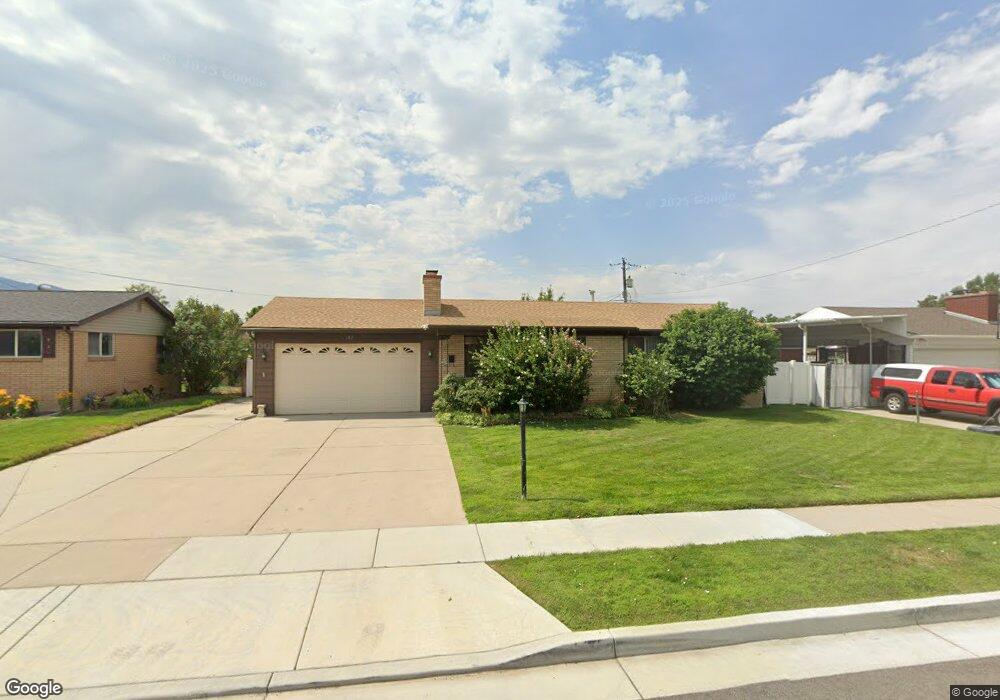
182 E 6715 S Midvale, UT 84047
Estimated Value: $529,000 - $572,000
4
Beds
3
Baths
2,156
Sq Ft
$255/Sq Ft
Est. Value
About This Home
This home is located at 182 E 6715 S, Midvale, UT 84047 and is currently estimated at $550,079, approximately $255 per square foot. 182 E 6715 S is a home located in Salt Lake County with nearby schools including East Midvale Elementary School, Hillcrest High School, and Midvale Middle School.
Ownership History
Date
Name
Owned For
Owner Type
Purchase Details
Closed on
Oct 11, 2007
Sold by
Cook Daniel H
Bought by
Haws Donald D and Bolander Juanita F
Current Estimated Value
Purchase Details
Closed on
Aug 9, 2005
Sold by
Hud
Bought by
Cook Daniel H
Home Financials for this Owner
Home Financials are based on the most recent Mortgage that was taken out on this home.
Original Mortgage
$154,890
Interest Rate
5.48%
Mortgage Type
Fannie Mae Freddie Mac
Purchase Details
Closed on
May 18, 2005
Sold by
Wells Fargo Bank Na
Bought by
Secretary Of Hud
Purchase Details
Closed on
Apr 15, 2005
Sold by
Larson Bonnie J and Larson Gordon J
Bought by
Mortgage Electronic Registration Systems
Purchase Details
Closed on
Nov 16, 2001
Sold by
Nelson Gaylen J and Nelson Deanna
Bought by
Larson Gordon J and Larson Bonnie J
Home Financials for this Owner
Home Financials are based on the most recent Mortgage that was taken out on this home.
Original Mortgage
$152,785
Interest Rate
6.57%
Mortgage Type
FHA
Create a Home Valuation Report for This Property
The Home Valuation Report is an in-depth analysis detailing your home's value as well as a comparison with similar homes in the area
Home Values in the Area
Average Home Value in this Area
Purchase History
| Date | Buyer | Sale Price | Title Company |
|---|---|---|---|
| Haws Donald D | -- | Meridian Title | |
| Cook Daniel H | -- | Monument Title Ins Co | |
| Secretary Of Hud | -- | Backman Title Services | |
| Mortgage Electronic Registration Systems | $161,818 | -- | |
| Larson Gordon J | -- | Surety Title Corporation |
Source: Public Records
Mortgage History
| Date | Status | Borrower | Loan Amount |
|---|---|---|---|
| Previous Owner | Cook Daniel H | $154,890 | |
| Previous Owner | Larson Gordon J | $152,785 |
Source: Public Records
Tax History
| Year | Tax Paid | Tax Assessment Tax Assessment Total Assessment is a certain percentage of the fair market value that is determined by local assessors to be the total taxable value of land and additions on the property. | Land | Improvement |
|---|---|---|---|---|
| 2025 | $2,869 | $492,000 | $170,200 | $321,800 |
| 2024 | $2,869 | $471,100 | $160,700 | $310,400 |
| 2023 | $2,694 | $438,300 | $152,700 | $285,600 |
| 2022 | $2,822 | $448,400 | $127,300 | $321,100 |
| 2021 | $2,519 | $342,300 | $117,500 | $224,800 |
| 2020 | $2,397 | $308,200 | $96,500 | $211,700 |
| 2019 | $2,302 | $288,400 | $91,000 | $197,400 |
| 2016 | $1,885 | $222,600 | $91,000 | $131,600 |
Source: Public Records
Map
Nearby Homes
- 6714 S Vaughn Ln Unit 23
- 6716 S Vaughn Ln Unit 22
- 6720 S Vaughn Ln Unit 20
- 6718 S Vaughn Ln Unit 21
- 6715 S Vaughn Ln Unit 8
- 6717 S Vaughn Ln Unit 9
- 283 E Vaughn Ln Unit 12
- 24 W Lester Ave Unit C11
- 30 W Lester Ave Unit D17
- 6954 S 85 E
- 347 E Winchester St
- 288 E 6280 S
- 195 E 7060 S
- 7045 S 65 E
- 7033 S 300 E
- 7045 S 300 E
- 512 E Larchwood Dr
- 7097 S 230 E
- 6557 S 130 W Unit LOT 2
- 6555 S 130 W Unit LOT 1
Your Personal Tour Guide
Ask me questions while you tour the home.