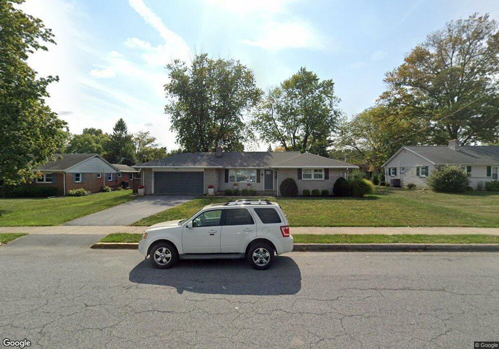
182 Hershey Dr Manheim, PA 17545
Estimated Value: $291,000 - $378,000
3
Beds
1
Bath
1,522
Sq Ft
$222/Sq Ft
Est. Value
About This Home
This home is located at 182 Hershey Dr, Manheim, PA 17545 and is currently estimated at $337,916, approximately $222 per square foot. 182 Hershey Dr is a home located in Lancaster County with nearby schools including Manheim Central Senior High School, Manheim Christian Day School, and Sporting Hill Christian School.
Ownership History
Date
Name
Owned For
Owner Type
Purchase Details
Closed on
Sep 5, 2002
Sold by
Neifert Kelly A and Barto Kelly A
Bought by
Neifert Adam and Neifert Kelly A
Current Estimated Value
Purchase Details
Closed on
May 28, 2002
Sold by
Adams Wilson M and Adams Doris A
Bought by
Barto Kelly A
Home Financials for this Owner
Home Financials are based on the most recent Mortgage that was taken out on this home.
Original Mortgage
$120,000
Interest Rate
7%
Mortgage Type
Seller Take Back
Create a Home Valuation Report for This Property
The Home Valuation Report is an in-depth analysis detailing your home's value as well as a comparison with similar homes in the area
Home Values in the Area
Average Home Value in this Area
Purchase History
| Date | Buyer | Sale Price | Title Company |
|---|---|---|---|
| Neifert Adam | -- | -- | |
| Barto Kelly A | -- | -- |
Source: Public Records
Mortgage History
| Date | Status | Borrower | Loan Amount |
|---|---|---|---|
| Closed | Barto Kelly A | $120,000 |
Source: Public Records
Tax History
| Year | Tax Paid | Tax Assessment Tax Assessment Total Assessment is a certain percentage of the fair market value that is determined by local assessors to be the total taxable value of land and additions on the property. | Land | Improvement |
|---|---|---|---|---|
| 2025 | $4,161 | $172,700 | $54,500 | $118,200 |
| 2024 | $4,161 | $172,700 | $54,500 | $118,200 |
| 2023 | $4,087 | $172,700 | $54,500 | $118,200 |
| 2022 | $3,955 | $172,700 | $54,500 | $118,200 |
| 2021 | $3,836 | $172,700 | $54,500 | $118,200 |
| 2020 | $3,836 | $172,700 | $54,500 | $118,200 |
| 2019 | $3,779 | $172,700 | $54,500 | $118,200 |
| 2018 | $4,373 | $172,700 | $54,500 | $118,200 |
| 2017 | $3,677 | $134,400 | $43,000 | $91,400 |
| 2016 | $3,569 | $134,400 | $43,000 | $91,400 |
| 2015 | $1,181 | $134,400 | $43,000 | $91,400 |
| 2014 | $2,188 | $134,400 | $43,000 | $91,400 |
Source: Public Records
Map
Nearby Homes
- 209 N Laurel St
- 130 Julia Ln
- 33 E Gramby St
- 126 N Charlotte St
- 81 S Linden St
- 2 S Charlotte St
- 37 W Ferdinand St
- 820 Cambridge Dr Unit 77
- 714 Heather Ridge Unit 140
- 854 Cambridge Dr Unit 7
- 730 Heather Ridge Unit 146
- 988 Cambridge Dr
- 900 Cambridge Dr
- 9 Vista Ln
- 600 Park Hill Dr
- 612 Park Hill Dr
- 1225 Shumaker Rd
- 629 Park Hill Dr
- 467 Hamilton Ct
- 742 Power Rd
- 174 Hershey Dr
- 190 Hershey Dr
- 195 N Laurel St
- 203 N Laurel St
- 200 Hershey Dr
- 189 N Laurel St
- 215 N Laurel St
- 166 Hershey Dr
- 185 N Laurel St
- 208 Hershey Dr
- 219 N Laurel St
- 196 N Laurel St
- 204 N Laurel St
- 179 N Laurel St
- 162 Hershey Dr
- 190 N Laurel St
- 210 N Laurel St
- 216 Hershey Dr
- 216 N Laurel St
- 225 N Laurel St
Your Personal Tour Guide
Ask me questions while you tour the home.