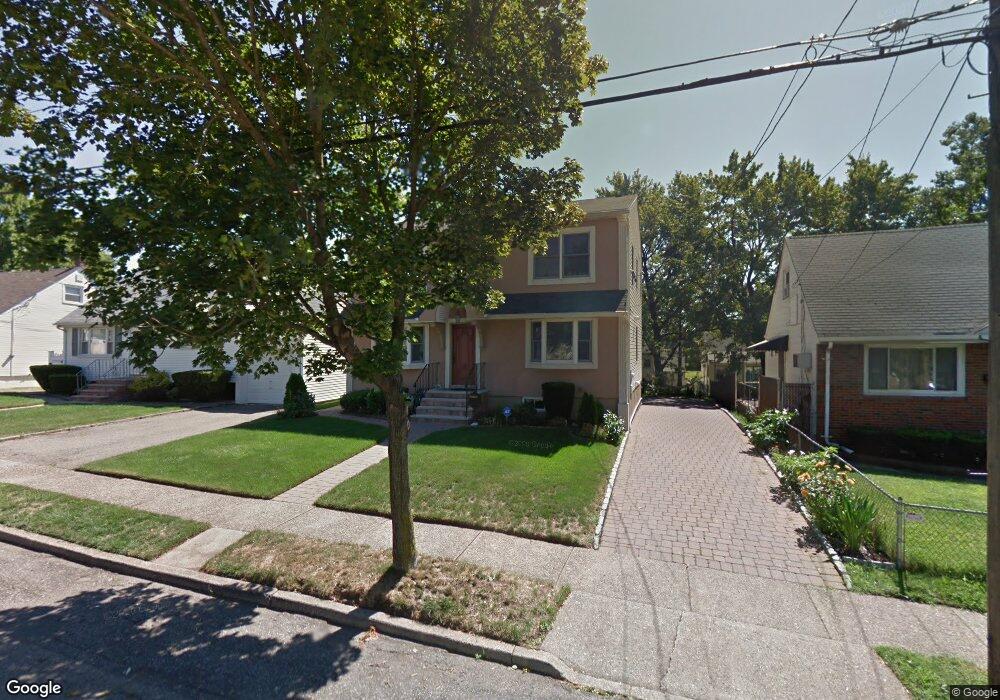
182 Poor St Hackensack, NJ 07601
Estimated Value: $651,000 - $766,000
Studio
--
Bath
2,176
Sq Ft
$322/Sq Ft
Est. Value
About This Home
This home is located at 182 Poor St, Hackensack, NJ 07601 and is currently estimated at $700,962, approximately $322 per square foot. 182 Poor St is a home located in Bergen County with nearby schools including Hackensack High School, Corpus Christi School, and George Washington School.
Ownership History
Date
Name
Owned For
Owner Type
Purchase Details
Closed on
Feb 23, 2024
Sold by
Shepherd Derrick E and Shepherd Sonia S
Bought by
Shepherd Derrick E and Shepherd Derrick E
Current Estimated Value
Home Financials for this Owner
Home Financials are based on the most recent Mortgage that was taken out on this home.
Original Mortgage
$325,000
Outstanding Balance
$319,278
Interest Rate
6.63%
Mortgage Type
New Conventional
Estimated Equity
$381,684
Purchase Details
Closed on
Aug 26, 1999
Sold by
Christiansen Robert
Bought by
Shepherd Derrick E and Shepherd Sonia S
Home Financials for this Owner
Home Financials are based on the most recent Mortgage that was taken out on this home.
Original Mortgage
$152,000
Interest Rate
7.53%
Mortgage Type
Purchase Money Mortgage
Create a Home Valuation Report for This Property
The Home Valuation Report is an in-depth analysis detailing your home's value as well as a comparison with similar homes in the area
Home Values in the Area
Average Home Value in this Area
Purchase History
| Date | Buyer | Sale Price | Title Company |
|---|---|---|---|
| Shepherd Derrick E | $185,000 | Elite Title | |
| Shepherd Derrick E | $185,000 | Elite Title | |
| Shepherd Derrick E | $160,000 | -- |
Source: Public Records
Mortgage History
| Date | Status | Borrower | Loan Amount |
|---|---|---|---|
| Open | Shepherd Derrick E | $325,000 | |
| Closed | Shepherd Derrick E | $325,000 | |
| Previous Owner | Shepherd Derrick E | $152,000 |
Source: Public Records
Tax History
| Year | Tax Paid | Tax Assessment Tax Assessment Total Assessment is a certain percentage of the fair market value that is determined by local assessors to be the total taxable value of land and additions on the property. | Land | Improvement |
|---|---|---|---|---|
| 2025 | $13,847 | $453,100 | $191,300 | $261,800 |
| 2024 | $13,045 | $453,100 | $191,300 | $261,800 |
| 2023 | $12,217 | $453,100 | $191,300 | $261,800 |
| 2022 | $12,217 | $436,000 | $175,000 | $261,000 |
| 2021 | $11,954 | $356,000 | $147,500 | $208,500 |
| 2020 | $11,780 | $356,000 | $147,500 | $208,500 |
| 2019 | $11,776 | $350,800 | $145,000 | $205,800 |
| 2018 | $11,918 | $349,200 | $142,500 | $206,700 |
| 2017 | $11,748 | $344,000 | $140,000 | $204,000 |
| 2016 | $11,188 | $331,200 | $130,000 | $201,200 |
| 2015 | $13,167 | $376,200 | $150,000 | $226,200 |
| 2014 | $12,497 | $376,200 | $150,000 | $226,200 |
Source: Public Records
Map
Nearby Homes
- 311 Marvin Ave
- 279 Clark St Unit A-7
- 115 Polifly Rd Unit 5D
- 229 Baldwin Ave
- 73 Macarthur Ave
- 448 Sutton Ave
- 54 Polifly Rd Unit 201
- 270 Baldwin Ave
- 528 Terrace Ave
- 90 Prospect Ave Unit 2A
- 90 Prospect Ave Unit 9B
- 301 Beech St Unit 10I
- 301 Beech St Unit 2B
- 252 Church St
- 115 Kansas St
- 113 Kansas St
- 75 Union St Unit 5E
- 99 Kansas St
- 225 Albert St
- 125 Prospect Ave Unit 17G
Your Personal Tour Guide
Ask me questions while you tour the home.