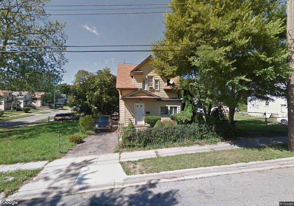
182 S Shirley St Pontiac, MI 48342
Estimated Value: $126,000 - $194,000
3
Beds
2
Baths
1,364
Sq Ft
$109/Sq Ft
Est. Value
About This Home
This home is located at 182 S Shirley St, Pontiac, MI 48342 and is currently estimated at $149,000, approximately $109 per square foot. 182 S Shirley St is a home located in Oakland County with nearby schools including Walt Whitman Elementary School, Pontiac Middle School, and Pontiac High School.
Ownership History
Date
Name
Owned For
Owner Type
Purchase Details
Closed on
Jul 17, 2019
Sold by
County Of Oakland
Bought by
Mason Blue Llc
Current Estimated Value
Purchase Details
Closed on
Nov 14, 2005
Sold by
Rose Financial Services Ltd
Bought by
Nunez Jose L
Home Financials for this Owner
Home Financials are based on the most recent Mortgage that was taken out on this home.
Original Mortgage
$46,800
Interest Rate
7.94%
Mortgage Type
Adjustable Rate Mortgage/ARM
Purchase Details
Closed on
Aug 26, 2002
Sold by
Crane Jeremy
Bought by
Rose Financial Serv Ltd
Create a Home Valuation Report for This Property
The Home Valuation Report is an in-depth analysis detailing your home's value as well as a comparison with similar homes in the area
Home Values in the Area
Average Home Value in this Area
Purchase History
| Date | Buyer | Sale Price | Title Company |
|---|---|---|---|
| Mason Blue Llc | $21,000 | None Available | |
| Nunez Jose L | $52,000 | Philip R Seaver Title Co Inc | |
| Rose Financial Serv Ltd | -- | -- |
Source: Public Records
Mortgage History
| Date | Status | Borrower | Loan Amount |
|---|---|---|---|
| Previous Owner | Nunez Jose L | $46,800 |
Source: Public Records
Tax History Compared to Growth
Tax History
| Year | Tax Paid | Tax Assessment Tax Assessment Total Assessment is a certain percentage of the fair market value that is determined by local assessors to be the total taxable value of land and additions on the property. | Land | Improvement |
|---|---|---|---|---|
| 2024 | $1,223 | $29,480 | $0 | $0 |
| 2023 | $1,166 | $25,900 | $0 | $0 |
| 2022 | $1,187 | $22,650 | $0 | $0 |
| 2021 | $1,152 | $21,790 | $0 | $0 |
| 2020 | $1,059 | $19,290 | $0 | $0 |
| 2019 | $797 | $16,560 | $0 | $0 |
| 2018 | $1,208 | $14,780 | $0 | $0 |
| 2017 | $734 | $14,080 | $0 | $0 |
| 2016 | $2,105 | $13,650 | $0 | $0 |
| 2015 | -- | $12,730 | $0 | $0 |
| 2014 | -- | $12,440 | $0 | $0 |
| 2011 | -- | $18,880 | $0 | $0 |
Source: Public Records
Map
Nearby Homes
- 328 Whittemore St
- 187 Wall St
- 176 S Francis Ave
- 397 S Jessie St
- 000 Wall St
- 505 Auburn Ave
- 33 S Tasmania St
- 389 Osmun St
- 18 S Shirley St
- 511 E Pike St
- 53 N Roselawn St
- 55 N Roselawn St
- 28 S Marshall St
- 57 N Roselawn St
- 70 N Roselawn St
- 59 Bellevue St
- 54 Bellevue St
- 97 N Roselawn St
- 472 S Jessie St
- 46 N Anderson Ave
- 186 S Shirley St
- 345 Whittemore St
- 341 Whittemore St
- 174 S Shirley St
- 00 Whittemore St
- 0 Whittemore St
- 339 Whittemore St
- 170 S Shirley St
- 335 Whittemore St
- 183 S Shirley St
- 185 S Shirley St
- 179 S Shirley St
- 166 S Shirley St
- 350 Whittemore St
- 350 E Judson St
- 171 S Shirley St
- 362 Whittemore St
- 344 Whittemore St
- 329 Whittemore St
- 162 S Shirley St