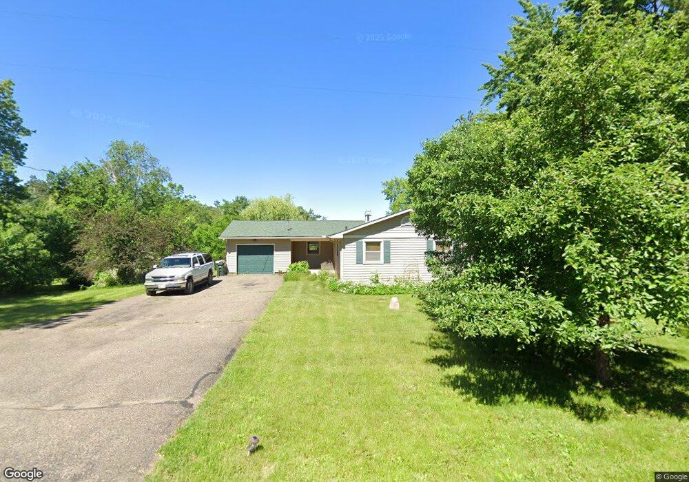
1820 143rd St New Richmond, WI 54017
Estimated Value: $362,000 - $371,037
4
Beds
2
Baths
1,905
Sq Ft
$192/Sq Ft
Est. Value
About This Home
This home is located at 1820 143rd St, New Richmond, WI 54017 and is currently estimated at $366,259, approximately $192 per square foot. 1820 143rd St is a home located in St. Croix County with nearby schools including New Richmond High School and St. Mary School.
Ownership History
Date
Name
Owned For
Owner Type
Purchase Details
Closed on
May 16, 2022
Sold by
Volkert and Mary
Bought by
Morusupalli Rao Narasimha and Morusupalli Kanaka Mahalakshmi
Current Estimated Value
Home Financials for this Owner
Home Financials are based on the most recent Mortgage that was taken out on this home.
Original Mortgage
$318,250
Outstanding Balance
$302,465
Interest Rate
5.3%
Mortgage Type
New Conventional
Estimated Equity
$63,794
Purchase Details
Closed on
Mar 7, 2007
Sold by
Vokert Robert M and Vokert Maxine
Bought by
Volkert Curtis and Volkert Mary
Home Financials for this Owner
Home Financials are based on the most recent Mortgage that was taken out on this home.
Original Mortgage
$110,000
Interest Rate
6.28%
Mortgage Type
New Conventional
Create a Home Valuation Report for This Property
The Home Valuation Report is an in-depth analysis detailing your home's value as well as a comparison with similar homes in the area
Home Values in the Area
Average Home Value in this Area
Purchase History
| Date | Buyer | Sale Price | Title Company |
|---|---|---|---|
| Morusupalli Rao Narasimha | $335,000 | None Listed On Document | |
| Volkert Curtis | $225,900 | None Available |
Source: Public Records
Mortgage History
| Date | Status | Borrower | Loan Amount |
|---|---|---|---|
| Open | Morusupalli Rao Narasimha | $318,250 | |
| Previous Owner | Volkert Curtis | $110,000 |
Source: Public Records
Tax History Compared to Growth
Tax History
| Year | Tax Paid | Tax Assessment Tax Assessment Total Assessment is a certain percentage of the fair market value that is determined by local assessors to be the total taxable value of land and additions on the property. | Land | Improvement |
|---|---|---|---|---|
| 2024 | $36 | $228,700 | $35,000 | $193,700 |
| 2023 | $3,146 | $228,700 | $35,000 | $193,700 |
| 2022 | $2,942 | $228,700 | $35,000 | $193,700 |
| 2021 | $2,983 | $228,700 | $35,000 | $193,700 |
| 2020 | $2,961 | $228,700 | $35,000 | $193,700 |
| 2019 | $2,608 | $193,600 | $35,000 | $158,600 |
| 2018 | $2,628 | $148,100 | $30,000 | $118,100 |
| 2017 | $2,476 | $148,100 | $30,000 | $118,100 |
| 2016 | $2,476 | $148,100 | $30,000 | $118,100 |
| 2015 | $2,379 | $148,100 | $30,000 | $118,100 |
| 2014 | $2,279 | $148,100 | $30,000 | $118,100 |
| 2013 | $2,327 | $145,100 | $30,000 | $115,100 |
Source: Public Records
Map
Nearby Homes
- 1826 143rd St
- 961 N Shore Dr
- 844 Brady Ln
- 1860 146th St
- 1157 N Shore Drive Lot 12 Dr
- 580 Evergreen Dr Unit 21
- 1456 Otter Way
- 1458 Otter Way
- 956 Turner Ln
- 1094 N Shore Dr
- 1133 N Shore Dr
- 602 Grouse Way
- 987 Turner Ln
- 1510 Raccoon Ln
- 1641 Possum Way
- 115 N Green Ave
- 1651 Possum Way
- 1172 Caneel St
- The Weston Plan at Fox Run
- The Madison Plan at Fox Run