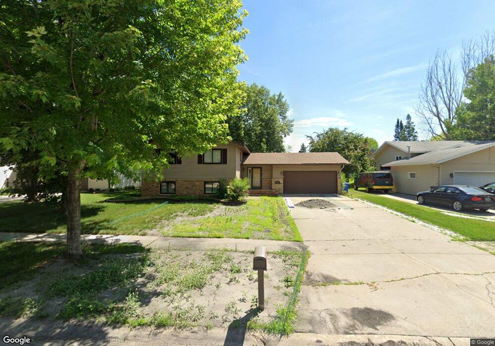
1820 19th St S Fargo, ND 58103
South High NeighborhoodEstimated Value: $279,296 - $337,000
3
Beds
2
Baths
2,128
Sq Ft
$148/Sq Ft
Est. Value
About This Home
This home is located at 1820 19th St S, Fargo, ND 58103 and is currently estimated at $314,824, approximately $147 per square foot. 1820 19th St S is a home located in Cass County with nearby schools including Lewis & Clark Elementary School, Carl Ben Eielson Middle School, and South High School.
Ownership History
Date
Name
Owned For
Owner Type
Purchase Details
Closed on
Aug 14, 2020
Sold by
Walski Aaron and Walski Stephanie
Bought by
Ward Letony and Ward Lisa
Current Estimated Value
Home Financials for this Owner
Home Financials are based on the most recent Mortgage that was taken out on this home.
Original Mortgage
$265,000
Outstanding Balance
$235,074
Interest Rate
3%
Mortgage Type
VA
Estimated Equity
$79,750
Purchase Details
Closed on
Mar 29, 2016
Sold by
Hall Erin and Hall Thomas R
Bought by
Walski Aaron and Walski Stephanie
Home Financials for this Owner
Home Financials are based on the most recent Mortgage that was taken out on this home.
Original Mortgage
$168,000
Interest Rate
3.65%
Mortgage Type
New Conventional
Purchase Details
Closed on
Feb 6, 2015
Sold by
Walaker Marry S
Bought by
Hall Erin M and Walaker Shannon M
Create a Home Valuation Report for This Property
The Home Valuation Report is an in-depth analysis detailing your home's value as well as a comparison with similar homes in the area
Home Values in the Area
Average Home Value in this Area
Purchase History
| Date | Buyer | Sale Price | Title Company |
|---|---|---|---|
| Ward Letony | $265,000 | Fm Title | |
| Walski Aaron | $210,000 | Title Co | |
| Hall Erin M | -- | None Available |
Source: Public Records
Mortgage History
| Date | Status | Borrower | Loan Amount |
|---|---|---|---|
| Open | Ward Letony | $265,000 | |
| Previous Owner | Walski Aaron | $168,000 |
Source: Public Records
Tax History
| Year | Tax Paid | Tax Assessment Tax Assessment Total Assessment is a certain percentage of the fair market value that is determined by local assessors to be the total taxable value of land and additions on the property. | Land | Improvement |
|---|---|---|---|---|
| 2024 | $3,144 | $140,150 | $33,650 | $106,500 |
| 2023 | $3,559 | $126,250 | $33,650 | $92,600 |
| 2022 | $3,438 | $118,000 | $33,650 | $84,350 |
| 2021 | $3,219 | $111,950 | $34,100 | $77,850 |
| 2020 | $2,911 | $101,750 | $34,100 | $67,650 |
| 2019 | $2,914 | $101,750 | $21,300 | $80,450 |
| 2018 | $2,877 | $101,750 | $21,300 | $80,450 |
| 2017 | $2,773 | $98,800 | $21,300 | $77,500 |
| 2016 | $2,406 | $95,900 | $21,300 | $74,600 |
| 2015 | $2,285 | $85,350 | $14,500 | $70,850 |
| 2014 | $2,052 | $74,200 | $14,500 | $59,700 |
| 2013 | $1,982 | $74,200 | $14,500 | $59,700 |
Source: Public Records
Map
Nearby Homes
- 1721 17th St S
- 1943 19th St S
- 2320 20th Ave S Unit 7
- 2326 20th Ave S Unit 9
- 2366 20th Ave S
- 2012 Park Blvd S Unit B4
- 1840 15th Ave S
- 1722 15th St S
- 1834 14 1 2 St S
- 1502 16th Ave S
- 1526 16 1 2 St S
- 2202 15th Ave S
- 2201 15th St S
- 2308 18th St S Unit H
- 2408 16th Ave S
- 1605 14th St S
- 2402 18th St S Unit 3
- 1630 14th St S
- 1510 15th St S
- 1438 19th St S
Your Personal Tour Guide
Ask me questions while you tour the home.