Estimated Value: $291,490 - $327,000
3
Beds
3
Baths
2,196
Sq Ft
$144/Sq Ft
Est. Value
About This Home
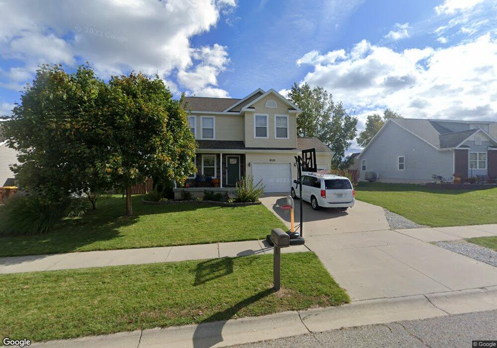
This home is located at 1820 Hollowbrook Dr, Holt, MI 48842 and is currently estimated at $316,373, approximately $144 per square foot. 1820 Hollowbrook Dr is a home located in Ingham County with nearby schools including Horizon Elementary School, Washington Woods Middle School, and Holt Junior High School.
Ownership History
Date
Name
Owned For
Owner Type
Purchase Details
Closed on
May 20, 2010
Sold by
Mason State Bank
Bought by
Powell Clark W
Current Estimated Value
Home Financials for this Owner
Home Financials are based on the most recent Mortgage that was taken out on this home.
Original Mortgage
$132,795
Outstanding Balance
$90,090
Interest Rate
5.3%
Mortgage Type
VA
Estimated Equity
$226,283
Purchase Details
Closed on
Feb 27, 2009
Sold by
Westridge Homes Inc
Bought by
Mason State Bank
Purchase Details
Closed on
Oct 28, 2005
Sold by
Tmn Builders Inc
Bought by
Westridge Homes
Create a Home Valuation Report for This Property
The Home Valuation Report is an in-depth analysis detailing your home's value as well as a comparison with similar homes in the area
Home Values in the Area
Average Home Value in this Area
Purchase History
| Date | Buyer | Sale Price | Title Company |
|---|---|---|---|
| Powell Clark W | $130,000 | Multiple | |
| Mason State Bank | -- | None Available | |
| Westridge Homes | $546,000 | None Available |
Source: Public Records
Mortgage History
| Date | Status | Borrower | Loan Amount |
|---|---|---|---|
| Open | Powell Clark W | $132,795 |
Source: Public Records
Tax History Compared to Growth
Tax History
| Year | Tax Paid | Tax Assessment Tax Assessment Total Assessment is a certain percentage of the fair market value that is determined by local assessors to be the total taxable value of land and additions on the property. | Land | Improvement |
|---|---|---|---|---|
| 2025 | $4,337 | $129,000 | $28,600 | $100,400 |
| 2024 | $10 | $121,000 | $25,900 | $95,100 |
| 2023 | $3,893 | $107,100 | $21,700 | $85,400 |
| 2022 | $3,659 | $96,800 | $23,500 | $73,300 |
| 2021 | $3,529 | $94,500 | $17,500 | $77,000 |
| 2020 | $3,590 | $90,100 | $17,500 | $72,600 |
| 2019 | $3,534 | $83,700 | $13,100 | $70,600 |
| 2018 | $3,514 | $75,400 | $13,100 | $62,300 |
| 2017 | $3,187 | $75,400 | $13,100 | $62,300 |
| 2016 | $3,160 | $71,800 | $17,400 | $54,400 |
| 2015 | $3,083 | $63,200 | $34,721 | $28,479 |
| 2014 | $3,083 | $61,800 | $34,721 | $27,079 |
Source: Public Records
Map
Nearby Homes
- 1812 Hollowbrook Dr
- 1851 Hollowbrook Dr
- 1819 Merganser Dr
- 1820 Merganser Dr
- The Newton Plan at Meadow Ridge
- The Windsor Plan at Meadow Ridge
- The Hickory Plan at Meadow Ridge
- The Hatfield Plan at Meadow Ridge
- The Norway Plan at Meadow Ridge
- The Waverly Plan at Meadow Ridge
- The Westfield Plan at Meadow Ridge
- The Nantucket Plan at Meadow Ridge
- The Hartwell Plan at Meadow Ridge
- 1915 Hollowbrook Dr
- 1800 N Onondaga Rd
- 5909 Hemlock Dr
- 2134 Cedar Bend Dr
- 5386 Auben Ln
- 2174 Cedar Bend Dr
- 1946 Gunn Rd
- 1828 Hollowbrook Dr
- 1821 Nightingale
- 1815 Nightingale
- 1829 Nightingale
- 1836 Hollowbrook Dr
- 1804 Hollowbrook Dr
- 1827 Hollowbrook Dr
- 1835 Hollowbrook Dr
- 1819 Hollowbrook Dr
- 1837 Nightingale
- 1801 Nightingale
- 1796 Hollowbrook Dr
- 1844 Hollowbrook Dr
- 1843 Hollowbrook Dr
- 1811 Hollowbrook Dr
- 1845 Nightingale
- 1803 Hollowbrook Dr
- 1826 Parakeet
- 1852 Hollowbrook Dr
- 1826 Nightingale