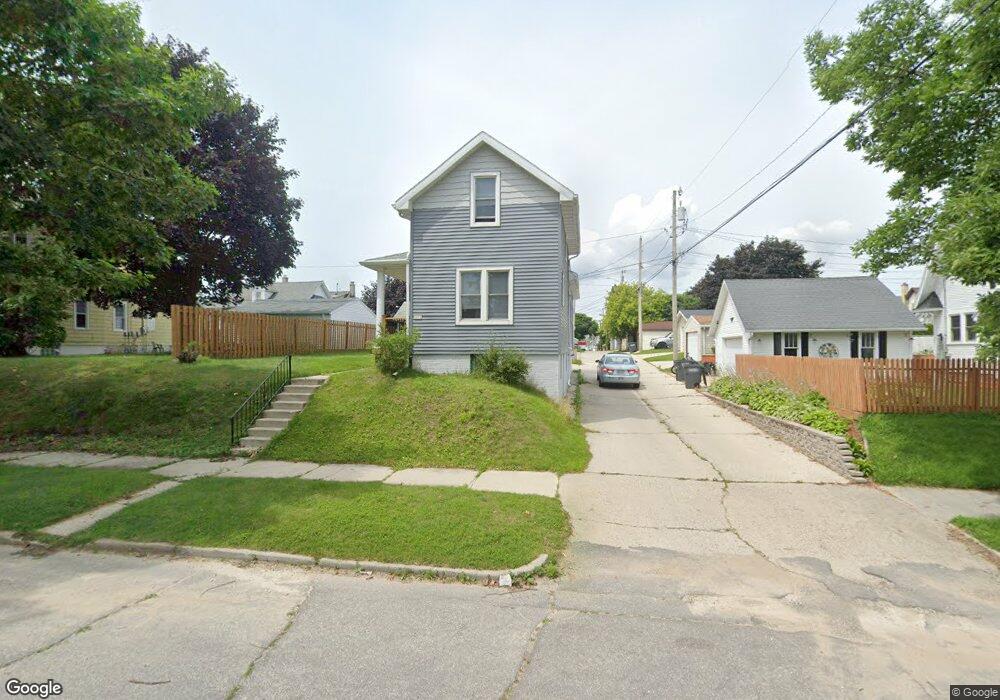
1820 S 9th St Sheboygan, WI 53081
Central Sheboygan NeighborhoodEstimated Value: $170,000 - $211,000
4
Beds
2
Baths
1,411
Sq Ft
$133/Sq Ft
Est. Value
About This Home
This home is located at 1820 S 9th St, Sheboygan, WI 53081 and is currently estimated at $187,932, approximately $133 per square foot. 1820 S 9th St is a home with nearby schools including Longfellow Elementary School, Farnsworth Middle School, and South High School.
Ownership History
Date
Name
Owned For
Owner Type
Purchase Details
Closed on
Jan 20, 2017
Sold by
Aprill Michael Michael
Bought by
Kettleview Properties Llc
Current Estimated Value
Purchase Details
Closed on
Nov 23, 2016
Sold by
Aprill Michael Michael
Bought by
Fannie Mae A/K/A Federal National Mortga
Purchase Details
Closed on
Feb 24, 2016
Sold by
Federal National Mortgage Association
Bought by
Den Boer Mariel L
Create a Home Valuation Report for This Property
The Home Valuation Report is an in-depth analysis detailing your home's value as well as a comparison with similar homes in the area
Home Values in the Area
Average Home Value in this Area
Purchase History
| Date | Buyer | Sale Price | Title Company |
|---|---|---|---|
| Kettleview Properties Llc | $35,000 | -- | |
| Fannie Mae A/K/A Federal National Mortga | $35,000 | -- | |
| Den Boer Mariel L | $37,600 | -- |
Source: Public Records
Tax History
| Year | Tax Paid | Tax Assessment Tax Assessment Total Assessment is a certain percentage of the fair market value that is determined by local assessors to be the total taxable value of land and additions on the property. | Land | Improvement |
|---|---|---|---|---|
| 2024 | $1,924 | $118,200 | $13,900 | $104,300 |
| 2023 | $1,709 | $97,500 | $13,200 | $84,300 |
| 2022 | $1,463 | $79,000 | $13,200 | $65,800 |
| 2021 | $1,453 | $57,800 | $11,400 | $46,400 |
| 2020 | $1,393 | $54,300 | $11,400 | $42,900 |
| 2019 | $1,334 | $54,300 | $11,400 | $42,900 |
| 2018 | $1,316 | $54,300 | $11,400 | $42,900 |
| 2017 | $1,276 | $54,300 | $11,400 | $42,900 |
| 2016 | $1,283 | $54,300 | $11,400 | $42,900 |
| 2015 | $1,333 | $54,300 | $11,400 | $42,900 |
| 2014 | $1,386 | $54,300 | $11,400 | $42,900 |
Source: Public Records
Map
Nearby Homes
- 1812 S 10th St
- 1126 High Ave
- 1610 S 11th St
- 2212 S 8th St
- 1934 S 12th St
- 1729 S 13th St
- 2317 S 9th St
- 1429 S 9th St
- 1335A Broadway Ave Unit 4
- 2417 S 8th St
- 924 Georgia Ave
- 1325 S 11th St
- 730 Georgia Ave
- 2407 Henry St
- 1918 S 16th St
- 2533 Lakeshore Dr
- 2126 S 16th St
- 2602 Henry St
- 1106 S 7th St Unit 1
- 1318 Humboldt Ave
- 1812 S 9th St
- 914 Swift Ave
- 904 Swift Ave
- 907 High Ave
- 911 High Ave
- 920 Swift Ave
- 917 High Ave
- 919 Swift Ave
- 917 Swift Ave
- 903 High Ave Unit 1806 S 9th St
- 913 High Ave
- 834 Swift Ave
- 922 Swift Ave
- 919 High Ave
- 1813 S 9th St
- 905 Swift Ave Unit 905A & 905B
- 830 Swift Ave
- 901 Swift Ave Unit Lower
- 901 Swift Ave
- 930 Swift Ave
Your Personal Tour Guide
Ask me questions while you tour the home.