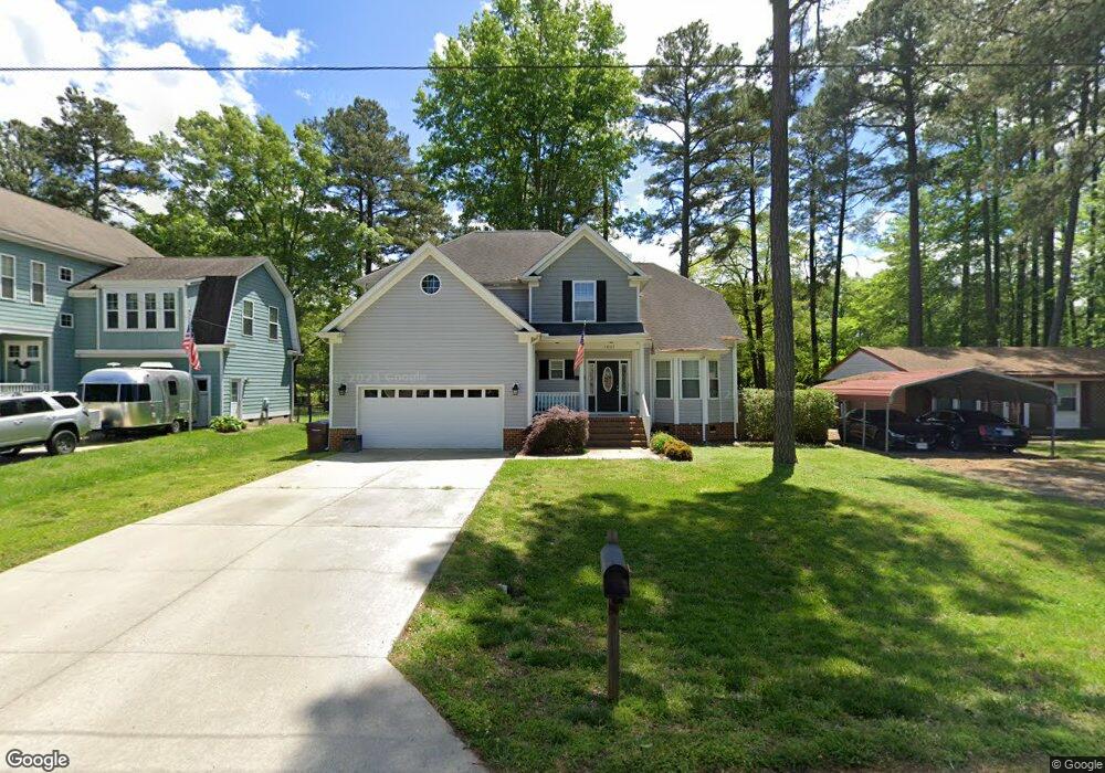
1821 Burson Dr Chesapeake, VA 23323
Deep Creek NeighborhoodEstimated Value: $546,000 - $615,000
4
Beds
4
Baths
2,418
Sq Ft
$240/Sq Ft
Est. Value
About This Home
This home is located at 1821 Burson Dr, Chesapeake, VA 23323 and is currently estimated at $579,660, approximately $239 per square foot. 1821 Burson Dr is a home located in Chesapeake City with nearby schools including Grassfield Elementary School, Hugo A. Owens Middle, and Grassfield High School.
Ownership History
Date
Name
Owned For
Owner Type
Purchase Details
Closed on
Mar 1, 2012
Sold by
Mcfarland Corprew
Bought by
Micon Properties Llc
Current Estimated Value
Home Financials for this Owner
Home Financials are based on the most recent Mortgage that was taken out on this home.
Original Mortgage
$190,000
Interest Rate
3.91%
Mortgage Type
New Conventional
Create a Home Valuation Report for This Property
The Home Valuation Report is an in-depth analysis detailing your home's value as well as a comparison with similar homes in the area
Home Values in the Area
Average Home Value in this Area
Purchase History
| Date | Buyer | Sale Price | Title Company |
|---|---|---|---|
| Micon Properties Llc | $65,000 | -- |
Source: Public Records
Mortgage History
| Date | Status | Borrower | Loan Amount |
|---|---|---|---|
| Previous Owner | Micon Properties Llc | $190,000 |
Source: Public Records
Tax History
| Year | Tax Paid | Tax Assessment Tax Assessment Total Assessment is a certain percentage of the fair market value that is determined by local assessors to be the total taxable value of land and additions on the property. | Land | Improvement |
|---|---|---|---|---|
| 2025 | $4,830 | $518,800 | $190,000 | $328,800 |
| 2024 | $4,830 | $478,200 | $175,000 | $303,200 |
| 2023 | $4,293 | $460,100 | $145,000 | $315,100 |
| 2022 | $4,298 | $425,500 | $135,000 | $290,500 |
| 2021 | $3,929 | $374,200 | $110,000 | $264,200 |
| 2020 | $3,808 | $362,700 | $105,000 | $257,700 |
| 2019 | $3,757 | $357,800 | $105,000 | $252,800 |
| 2018 | $3,705 | $345,600 | $95,000 | $250,600 |
| 2017 | $3,734 | $355,600 | $105,000 | $250,600 |
| 2016 | $3,681 | $350,600 | $100,000 | $250,600 |
| 2015 | $3,629 | $345,600 | $95,000 | $250,600 |
| 2014 | $3,506 | $333,900 | $90,000 | $243,900 |
Source: Public Records
Map
Nearby Homes
- 2014 Millville Rd
- 1969 Beechwood Rd
- 1908 Mccoy Rd
- 1916 Mccoy Rd
- 1906 Mccoy Rd
- 1904 Mccoy Rd
- 1972 Beechwood Rd
- 2226 Harton Ln
- 1949 Lemonwood Rd
- 1853 Rockwood Dr
- 1844 Rockwood Dr
- 1836 Rockwood Dr
- 1952 Lancing Crest Ln
- 1945 Lancing Crest Ln
- 1928 Moses Grandy Trail
- 1813 Sunsprite Loop
- 1920 Lancing Crest Ln
- 7.4 AC Moses Grandy Trail
- 2052 Burson Dr
- 2029 Shipyard Rd
- 1825 Burson Dr
- 1817 Burson Dr
- 1813 Burson Dr
- 1977 Reefwood Rd
- 1833 Burson Dr
- 1809 Burson Dr
- 1976 Reefwood Rd
- 1967 Reefwood Rd
- 1972 Reefwood Rd
- 1805 Burson Dr
- 2016 Kinston Waters Ct
- 2012 Kinston Waters Ct
- 1806 Burson Dr
- 1840 Burson Dr
- 2008 Kinston Waters Ct
- 1841 Burson Dr
- 1968 Reefwood Rd
- 2020 Kinston Waters Ct
- 1965 Reefwood Rd
- 1973 Millville Rd
Your Personal Tour Guide
Ask me questions while you tour the home.