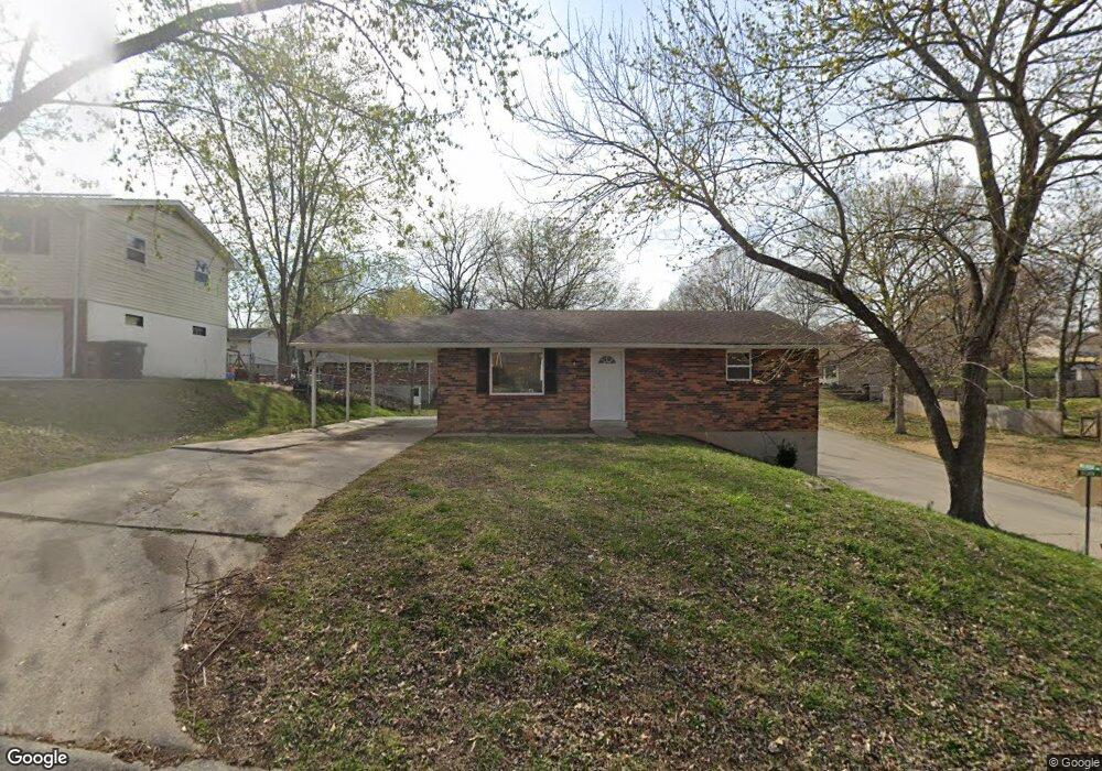
1821 Delwin St Cape Girardeau, MO 63701
Estimated Value: $163,079 - $179,000
2
Beds
2
Baths
936
Sq Ft
$183/Sq Ft
Est. Value
About This Home
This home is located at 1821 Delwin St, Cape Girardeau, MO 63701 and is currently estimated at $171,270, approximately $182 per square foot. 1821 Delwin St is a home with nearby schools including Alma Schrader Elementary School, Central Middle School, and Central Junior High School.
Ownership History
Date
Name
Owned For
Owner Type
Purchase Details
Closed on
Oct 15, 2024
Sold by
Glenn J Hutson And Anne B Hutson Family and Hutson Glenn J
Bought by
Hutson Enterprises Inc
Current Estimated Value
Home Financials for this Owner
Home Financials are based on the most recent Mortgage that was taken out on this home.
Original Mortgage
$195,000
Outstanding Balance
$192,950
Interest Rate
6.35%
Mortgage Type
New Conventional
Estimated Equity
-$21,680
Create a Home Valuation Report for This Property
The Home Valuation Report is an in-depth analysis detailing your home's value as well as a comparison with similar homes in the area
Home Values in the Area
Average Home Value in this Area
Purchase History
| Date | Buyer | Sale Price | Title Company |
|---|---|---|---|
| Hutson Enterprises Inc | -- | None Listed On Document |
Source: Public Records
Mortgage History
| Date | Status | Borrower | Loan Amount |
|---|---|---|---|
| Open | Hutson Enterprises Inc | $195,000 |
Source: Public Records
Tax History Compared to Growth
Tax History
| Year | Tax Paid | Tax Assessment Tax Assessment Total Assessment is a certain percentage of the fair market value that is determined by local assessors to be the total taxable value of land and additions on the property. | Land | Improvement |
|---|---|---|---|---|
| 2025 | $8 | $15,890 | $2,340 | $13,550 |
| 2024 | $8 | $15,140 | $2,230 | $12,910 |
| 2023 | $787 | $15,140 | $2,230 | $12,910 |
| 2022 | $725 | $13,940 | $2,050 | $11,890 |
| 2021 | $725 | $13,940 | $2,050 | $11,890 |
| 2020 | $727 | $13,940 | $2,050 | $11,890 |
| 2019 | $726 | $13,940 | $0 | $0 |
| 2018 | $724 | $13,940 | $0 | $0 |
| 2017 | $726 | $13,940 | $0 | $0 |
| 2016 | $678 | $13,070 | $0 | $0 |
| 2015 | $679 | $13,070 | $0 | $0 |
| 2014 | $682 | $13,070 | $0 | $0 |
Source: Public Records
Map
Nearby Homes
- 2550 Marvin St
- 2412 Masters Dr
- 1966 Randol Ave
- 1938 Westwood Dr
- 1701 Brookwood Dr
- 2449 Janet Dr
- 1960 Briarwood Dr
- 1912 Perryville Rd
- 2323 Brookwood Dr
- 1246 Marilyn Dr
- 1623 Lexington Ave
- 2062 Concord Place
- 1608 Lexington Ave
- 1705 Paul Revere Dr
- 1717 Perryville Rd
- 1107 Dorothy St
- 1910 Sherwood Dr
- 1070 Dorothy St
- 1572 Lexington Ave
- 2323 Jean Ann Dr
- 1817 Delwin St
- 19491953 Delwin St
- 19411945 Delwin St
- 1811 Delwin St
- 1901 Delwin St
- 1820 Longview Dr
- 1828 Delwin St
- 1824 Delwin St
- 1816 Longview Dr
- 1820 Delwin St
- 1812 Longview Dr
- 1809 Delwin St
- 2513 Melrose Ave
- 1812 Delwin St
- 2522 Melrose Ave
- 1808 Longview Dr
- 1905 Delwin St
- 1808 Delwin St
- 1825 Margaret St
- 1829 Margaret St