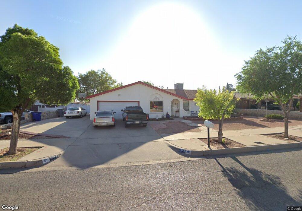
1824 Pete Brown Dr El Paso, TX 79936
Vista Del Sol NeighborhoodEstimated Value: $282,092 - $302,000
4
Beds
2
Baths
2,117
Sq Ft
$139/Sq Ft
Est. Value
About This Home
This home is located at 1824 Pete Brown Dr, El Paso, TX 79936 and is currently estimated at $294,023, approximately $138 per square foot. 1824 Pete Brown Dr is a home located in El Paso County with nearby schools including Tierra Del Sol Elementary School, J M Hanks High School, and EL PASO LEADERSHIP ACADEMY - MIDDLE EAST.
Ownership History
Date
Name
Owned For
Owner Type
Purchase Details
Closed on
Feb 8, 2020
Sold by
Lara Rogelio and Lara Maria L
Bought by
Lara Rogelio and Lara Maria L
Current Estimated Value
Purchase Details
Closed on
Sep 13, 1996
Sold by
Vargas Ramon and Vargas Emma
Bought by
Lara Rogelio and Lara Maria L
Home Financials for this Owner
Home Financials are based on the most recent Mortgage that was taken out on this home.
Original Mortgage
$86,400
Interest Rate
7.9%
Create a Home Valuation Report for This Property
The Home Valuation Report is an in-depth analysis detailing your home's value as well as a comparison with similar homes in the area
Home Values in the Area
Average Home Value in this Area
Purchase History
| Date | Buyer | Sale Price | Title Company |
|---|---|---|---|
| Lara Rogelio | -- | None Listed On Document | |
| Lara Rogelio | -- | -- |
Source: Public Records
Mortgage History
| Date | Status | Borrower | Loan Amount |
|---|---|---|---|
| Previous Owner | Lara Rogelio | $86,400 |
Source: Public Records
Tax History Compared to Growth
Tax History
| Year | Tax Paid | Tax Assessment Tax Assessment Total Assessment is a certain percentage of the fair market value that is determined by local assessors to be the total taxable value of land and additions on the property. | Land | Improvement |
|---|---|---|---|---|
| 2025 | $3,285 | $268,294 | -- | -- |
| 2024 | $3,285 | $243,904 | -- | -- |
| 2023 | $3,285 | $221,731 | $0 | $0 |
| 2022 | $6,260 | $201,574 | $0 | $0 |
| 2021 | $5,957 | $187,696 | $33,402 | $154,294 |
| 2020 | $5,262 | $166,590 | $30,319 | $136,271 |
| 2018 | $5,141 | $165,330 | $30,319 | $135,011 |
| 2017 | $4,618 | $151,090 | $30,319 | $120,771 |
| 2016 | $4,208 | $137,671 | $30,319 | $107,352 |
| 2015 | $3,318 | $137,671 | $30,319 | $107,352 |
| 2014 | $3,318 | $138,258 | $30,319 | $107,939 |
Source: Public Records
Map
Nearby Homes
- 1817 Hugh Royer Place
- 1868 Tom Bolt Dr
- 1901 Bobby Jones Dr
- 2001 Bobby Jones Dr Unit A
- 2009 Bobby Jones Dr Unit B
- 1913 Seagull Dr
- 11016 Bob Stone Dr
- 11012 Bob Stone Dr
- 11013 Bob Stone Dr
- 1844 Jack Nicklaus Dr Unit 1846
- 11204 Bob Mitchell Dr
- 1804 Jerry Abbott St
- 1739 Jerry Abbott St
- 11157 Leo Collins Dr
- 2604 Anise Dr
- 1703 Robert Wynn St
- 1617 Tommy Aaron Dr
- 11008 Johnny Miller Dr
- 2308 Tom Watson Ct
- 2201 Trawood Dr
- 1820 Pete Brown Dr
- 1828 Pete Brown Dr
- 1828 Pete Brown Place
- 1831 Mike Hill Dr
- 1833 Mike Hill Dr
- 1849 Billy Casper Dr
- 1816 Pete Brown Dr
- 1832 Pete Brown Dr
- 1819 Pete Brown Dr
- 1827 Mike Hill Dr
- 1829 Pete Brown Dr
- 1837 Mike Hill Dr
- 1845 Billy Casper Dr
- 1812 Pete Brown Dr
- 1813 Pete Brown Dr
- 1833 Pete Brown Dr
- 1846 Billy Casper Dr
- 1846 Billy Casper Dr Unit 1
- 1846 Billy Casper Dr
- 1836 Pete Brown Dr