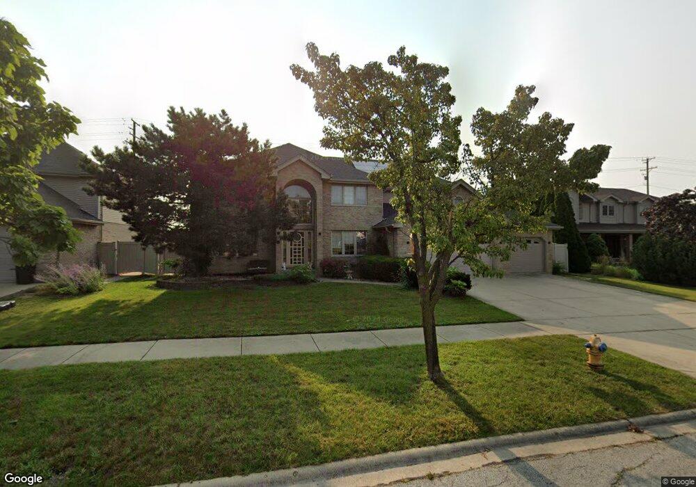
18241 Cork Rd Tinley Park, IL 60477
Central Tinley Park NeighborhoodEstimated Value: $614,948 - $655,000
4
Beds
3
Baths
3,392
Sq Ft
$188/Sq Ft
Est. Value
About This Home
This home is located at 18241 Cork Rd, Tinley Park, IL 60477 and is currently estimated at $636,737, approximately $187 per square foot. 18241 Cork Rd is a home located in Cook County with nearby schools including Millennium Elementary School, Virgil I Grissom Middle School, and Victor J Andrew High School.
Ownership History
Date
Name
Owned For
Owner Type
Purchase Details
Closed on
Feb 27, 2003
Sold by
State Bank Of Countryside
Bought by
Germino Eduardo P and Germino Estrella T
Current Estimated Value
Home Financials for this Owner
Home Financials are based on the most recent Mortgage that was taken out on this home.
Original Mortgage
$250,000
Outstanding Balance
$108,102
Interest Rate
5.96%
Estimated Equity
$528,635
Create a Home Valuation Report for This Property
The Home Valuation Report is an in-depth analysis detailing your home's value as well as a comparison with similar homes in the area
Home Values in the Area
Average Home Value in this Area
Purchase History
| Date | Buyer | Sale Price | Title Company |
|---|---|---|---|
| Germino Eduardo P | $328,500 | Enterprise Land Title Ltd |
Source: Public Records
Mortgage History
| Date | Status | Borrower | Loan Amount |
|---|---|---|---|
| Open | Germino Eduardo P | $250,000 |
Source: Public Records
Tax History Compared to Growth
Tax History
| Year | Tax Paid | Tax Assessment Tax Assessment Total Assessment is a certain percentage of the fair market value that is determined by local assessors to be the total taxable value of land and additions on the property. | Land | Improvement |
|---|---|---|---|---|
| 2024 | $12,503 | $51,000 | $14,089 | $36,911 |
| 2023 | $11,313 | $51,000 | $14,089 | $36,911 |
| 2022 | $11,313 | $35,152 | $6,078 | $29,074 |
| 2021 | $10,979 | $35,151 | $6,077 | $29,074 |
| 2020 | $10,771 | $35,151 | $6,077 | $29,074 |
| 2019 | $12,418 | $41,719 | $5,525 | $36,194 |
| 2018 | $12,150 | $41,719 | $5,525 | $36,194 |
| 2017 | $11,845 | $41,719 | $5,525 | $36,194 |
| 2016 | $11,422 | $36,887 | $4,972 | $31,915 |
| 2015 | $11,258 | $36,887 | $4,972 | $31,915 |
| 2014 | $11,179 | $36,887 | $4,972 | $31,915 |
| 2013 | $11,277 | $39,970 | $4,972 | $34,998 |
Source: Public Records
Map
Nearby Homes
- 8036 Blarney Rd
- 17908 Iroquois Trace
- 8416 Stratford Dr Unit 8416
- 8423 Stratford Dr Unit 8423
- 18261 Kirby Dr Unit 2918261
- 7783 Bristol Park Dr Unit 1-SW
- 7755 Bristol Park Dr Unit 1NE
- 7727 Bristol Park Dr
- 8313 Aster Ln
- 7925 Belle Rive Ct
- 18145 Harlem Ave
- 7517 175th St Unit 331
- 17631 Dover Ct
- 18212 Glen Swilly Cir
- 8030 Valley View Dr
- 18001 S Harlem Ave
- Fremont Plan at Radcliffe Place
- Calysta Plan at Radcliffe Place
- Danbury Plan at Radcliffe Place
- Briarcliffe Plan at Radcliffe Place