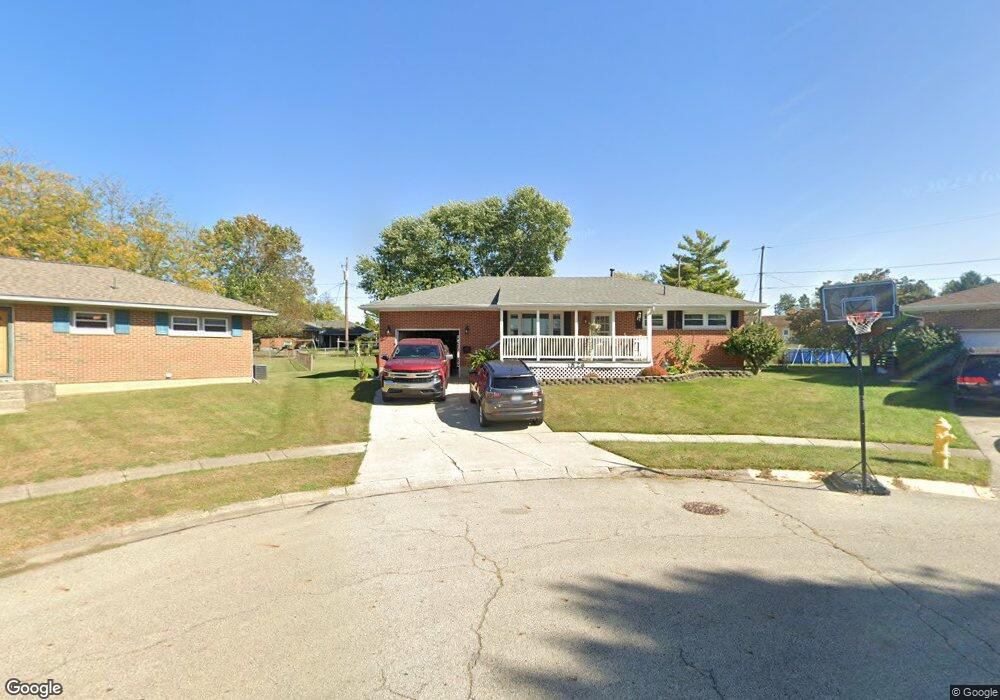
1826 Kimberly Ct Springfield, OH 45503
Estimated Value: $220,099 - $240,000
3
Beds
1
Bath
1,131
Sq Ft
$202/Sq Ft
Est. Value
About This Home
This home is located at 1826 Kimberly Ct, Springfield, OH 45503 and is currently estimated at $228,025, approximately $201 per square foot. 1826 Kimberly Ct is a home located in Clark County with nearby schools including Northridge Elementary School, Kenton Ridge Middle & High School, and Emmanuel Christian Academy.
Ownership History
Date
Name
Owned For
Owner Type
Purchase Details
Closed on
Sep 14, 2022
Sold by
Blain John I and Blain Nikki J
Bought by
Blain Irrevocable Heritage Trust
Current Estimated Value
Purchase Details
Closed on
Oct 1, 2010
Sold by
Williams James P and Williams James
Bought by
Bac Home Loans Servicing Lp and Countrywide Home Loans Servicing Lp
Create a Home Valuation Report for This Property
The Home Valuation Report is an in-depth analysis detailing your home's value as well as a comparison with similar homes in the area
Home Values in the Area
Average Home Value in this Area
Purchase History
| Date | Buyer | Sale Price | Title Company |
|---|---|---|---|
| Blain Irrevocable Heritage Trust | -- | -- | |
| Bac Home Loans Servicing Lp | $50,000 | Attorney |
Source: Public Records
Tax History
| Year | Tax Paid | Tax Assessment Tax Assessment Total Assessment is a certain percentage of the fair market value that is determined by local assessors to be the total taxable value of land and additions on the property. | Land | Improvement |
|---|---|---|---|---|
| 2025 | $2,480 | $70,500 | $16,520 | $53,980 |
| 2024 | $2,400 | $55,500 | $14,630 | $40,870 |
| 2023 | $2,400 | $55,500 | $14,630 | $40,870 |
| 2022 | $1,984 | $55,500 | $14,630 | $40,870 |
| 2021 | $1,675 | $42,200 | $11,340 | $30,860 |
| 2020 | $1,677 | $42,200 | $11,340 | $30,860 |
| 2019 | $1,709 | $42,200 | $11,340 | $30,860 |
| 2018 | $1,569 | $38,210 | $10,410 | $27,800 |
| 2017 | $1,344 | $37,458 | $10,406 | $27,052 |
| 2016 | $1,335 | $37,458 | $10,406 | $27,052 |
| 2015 | $1,409 | $37,153 | $10,101 | $27,052 |
| 2014 | $1,409 | $37,153 | $10,101 | $27,052 |
| 2013 | $1,376 | $37,153 | $10,101 | $27,052 |
Source: Public Records
Map
Nearby Homes
- 1921 Elaina Dr
- 3942 Harris Ln
- 4028 Ryland Dr Unit 4028
- 1811 Saint Andrews Ct
- 1711 Pinehurst Dr
- 1505 Kingsgate Rd
- 1503 Kingsgate Rd
- 1507 Kingsgate Rd
- 1500 Kingsgate Rd Unit 19430
- 1502 Kingsgate Rd Unit 19432
- 1500 Kingsgate Rd
- 1509 Kingsgate Rd
- 1502 Kingsgate Rd
- 3631 Kingsgate Ln
- 4256 Midfield St Unit 9
- 4322 Midfield St Unit 15
- 4446 Ridgewood Rd E Unit 3
- 4577 Reno Ln Unit 2
- 1341 Student Ave
- 3126 Lakeview Ct Unit 3126
- 1821 Kimberly Ct
- 1832 Kimberly Ct
- 1947 Elaina Dr
- 1941 Elaina Dr
- 1951 Elaina Dr
- 1918 Elaina Dr
- 1927 Elaina Dr
- 1838 Kimberly Ct
- 1908 Elaina Dr
- 1929 Delmar Dr
- 1813 Kimberly Ct
- 1937 Delmar Dr
- 1921 Delmar Dr
- 1900 Elaina Dr
- 1844 Kimberly Ct
- 1807 Kimberly Ct
- 1915 Delmar Dr
- 1836 Elaina Dr
- 1942 Elaina Dr
- 1948 Elaina Dr
Your Personal Tour Guide
Ask me questions while you tour the home.