Estimated Value: $229,000 - $279,000
3
Beds
2
Baths
1,311
Sq Ft
$198/Sq Ft
Est. Value
About This Home
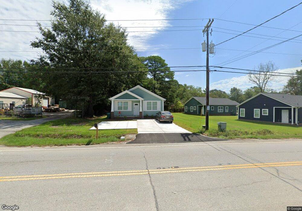
This home is located at 1827 Frink St, Cayce, SC 29033 and is currently estimated at $259,446, approximately $197 per square foot. 1827 Frink St is a home located in Lexington County with nearby schools including Cayce Elementary, Cyril B. Busbee Creative Arts Academy, and Brookland-Cayce High School.
Ownership History
Date
Name
Owned For
Owner Type
Purchase Details
Closed on
Apr 3, 2023
Sold by
Cypress Cove Properties Llc
Bought by
Chen Christopher Alan and Zhou Xiao Ling
Current Estimated Value
Home Financials for this Owner
Home Financials are based on the most recent Mortgage that was taken out on this home.
Original Mortgage
$170,000
Outstanding Balance
$163,496
Interest Rate
5.21%
Mortgage Type
New Conventional
Estimated Equity
$95,950
Purchase Details
Closed on
Feb 18, 2018
Sold by
Estate Of Gertrude Eliza Hammond and Harmon Jennifer H
Bought by
Harmon Jennifer H and Urhammer Belinda H
Create a Home Valuation Report for This Property
The Home Valuation Report is an in-depth analysis detailing your home's value as well as a comparison with similar homes in the area
Home Values in the Area
Average Home Value in this Area
Purchase History
| Date | Buyer | Sale Price | Title Company |
|---|---|---|---|
| Chen Christopher Alan | $249,900 | -- | |
| Harmon Jennifer H | $500 | None Available |
Source: Public Records
Mortgage History
| Date | Status | Borrower | Loan Amount |
|---|---|---|---|
| Open | Chen Christopher Alan | $170,000 |
Source: Public Records
Tax History
| Year | Tax Paid | Tax Assessment Tax Assessment Total Assessment is a certain percentage of the fair market value that is determined by local assessors to be the total taxable value of land and additions on the property. | Land | Improvement |
|---|---|---|---|---|
| 2024 | $1,756 | $14,994 | $1,500 | $13,494 |
| 2023 | $5,757 | $1,500 | $1,500 | $0 |
| 2022 | $539 | $1,500 | $1,500 | $0 |
| 2020 | $317 | $840 | $840 | $0 |
| 2019 | $291 | $840 | $840 | $0 |
| 2018 | $268 | $794 | $794 | $0 |
| 2017 | $264 | $794 | $794 | $0 |
| 2016 | $265 | $793 | $793 | $0 |
| 2014 | -- | $690 | $690 | $0 |
| 2013 | -- | $690 | $690 | $0 |
Source: Public Records
Map
Nearby Homes
- 2312 Lucas St
- 1740 Sunnyside Dr
- 1805 Chadsworth Dr
- 1515 Benedict St
- 000 Frink St
- 1832 Wadsworth Dr
- 2314 Orchard St
- 2402 Breezewood Rd
- 103 Pine Ln
- 1512 Summerland Dr
- 1414 Hazel St
- 1521 Benton Cir
- 1314 Northland Dr
- 133 Odell Dr
- 129 Odell Dr
- 121 Odell Dr
- 117 Odell Dr
- 1855 Evelyn St
- 1137 Allen St
- TBD Poplar Lots A B & C St
- 1803 Frink St
- 1805 Frink St
- 1825 Frink St
- 2301 Westview St
- 1811 Frink St
- 2309 Westview Dr
- 1723 Frink St
- 2312 Westview St
- 1815 Frink St
- 2309 Westview St
- 1721 Frink St
- 2313 Westview Dr
- 2316 Westview St
- 2316 Westview Dr
- 2313 Westview St
- 1715 Frink St
- 1819 Frink St
- 2317 Westview St
- 2317 Westview Dr
- 2318 Westview Dr
Your Personal Tour Guide
Ask me questions while you tour the home.