
1827 N Brownstone Ct SW Decatur, AL 35603
Westmead NeighborhoodEstimated payment $967/month
Highlights
- End Unit
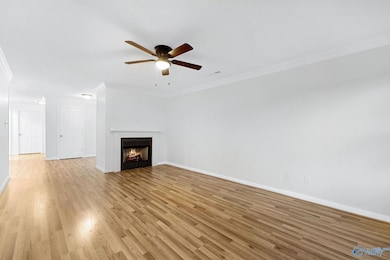
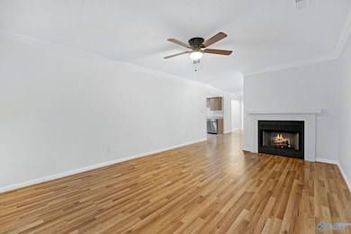
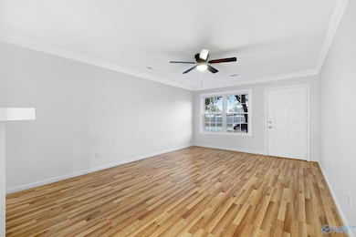
- Living Room
- Gas Log Fireplace
- No HOA
- Central Heating and Cooling System
About This Home
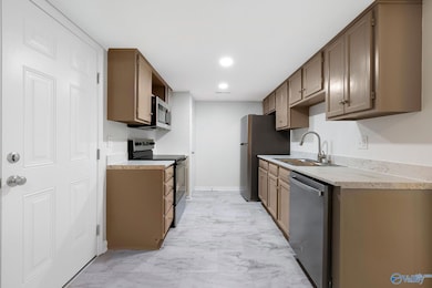
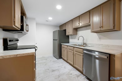
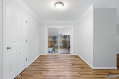
Welcome to this bright 2-bedroom, 2-bathroom townhouse with fresh paint, updated kitchen with stainless appliances, new floors, and stylishly updated bathrooms. Move-in ready!
Townhouse Details
Home Type
- Townhome
Est. Annual Taxes
- $490
Year Built
- Built in 1989
Lot Details
- Lot Dimensions are 35 x 115
- End Unit
Parking
- 1 Carport Space
Home Design
- Brick Exterior Construction
- Slab Foundation
Interior Spaces
- 1,280 Sq Ft Home
- Gas Log Fireplace
- Living Room
Bedrooms and Bathrooms
- 2 Bedrooms
- 2 Full Bathrooms
Schools
- Austin Middle Elementary School
- Austin High School
Utilities
- Central Heating and Cooling System
Community Details
- No Home Owners Association
- Westmeade Townhomes Subdivision
Listing and Financial Details
- Tax Lot 70
- Assessor Parcel Number 2 07 26 3 004 015.000
Map
Home Values in the Area
Average Home Value in this Area
Tax History
| Year | Tax Paid | Tax Assessment Tax Assessment Total Assessment is a certain percentage of the fair market value that is determined by local assessors to be the total taxable value of land and additions on the property. | Land | Improvement |
|---|---|---|---|---|
| 2024 | $490 | $11,840 | $1,610 | $10,230 |
| 2023 | $490 | $11,840 | $1,610 | $10,230 |
| 2022 | $462 | $11,260 | $1,520 | $9,740 |
| 2021 | $390 | $9,650 | $1,520 | $8,130 |
| 2020 | $356 | $16,320 | $1,500 | $14,820 |
| 2019 | $356 | $8,920 | $0 | $0 |
| 2015 | $313 | $7,960 | $0 | $0 |
| 2014 | $313 | $7,960 | $0 | $0 |
| 2013 | -- | $7,840 | $0 | $0 |
Property History
| Date | Event | Price | List to Sale | Price per Sq Ft |
|---|---|---|---|---|
| 11/11/2025 11/11/25 | Price Changed | $175,500 | -1.1% | $137 / Sq Ft |
| 10/27/2025 10/27/25 | Price Changed | $177,500 | -0.8% | $139 / Sq Ft |
| 10/21/2025 10/21/25 | Price Changed | $178,900 | -0.1% | $140 / Sq Ft |
| 10/07/2025 10/07/25 | Price Changed | $179,000 | -3.2% | $140 / Sq Ft |
| 09/30/2025 09/30/25 | Price Changed | $185,000 | -2.1% | $145 / Sq Ft |
| 09/21/2025 09/21/25 | For Sale | $189,000 | -- | $148 / Sq Ft |
Purchase History
| Date | Type | Sale Price | Title Company |
|---|---|---|---|
| Warranty Deed | $125,000 | None Listed On Document | |
| Warranty Deed | $125,000 | None Listed On Document | |
| Warranty Deed | -- | None Available | |
| Warranty Deed | $72,500 | None Available |
Mortgage History
| Date | Status | Loan Amount | Loan Type |
|---|---|---|---|
| Open | $126,013 | Balloon | |
| Closed | $126,013 | Balloon | |
| Previous Owner | $84,857 | FHA | |
| Previous Owner | $71,379 | FHA |
Source: ValleyMLS.com
MLS Number: 21899676
APN: 02-07-26-3-004-015.000
Disclaimer: Certain information contained herein is derived from information provided by parties other than Homes.com. All information provided is deemed reliable, but is not guaranteed to be accurate and should be independently verified.
![]() Properties marked with this icon are provided courtesy of the Valley MLS IDX Database. Some or all of the listings displayed may not belong to the firm whose website is being visited.
Properties marked with this icon are provided courtesy of the Valley MLS IDX Database. Some or all of the listings displayed may not belong to the firm whose website is being visited.
All information provided is deemed reliable but is not guaranteed and should be independently verified.
Copyright 2025 Valley MLS
- 1812 Brownstone Ave SW
- 1904 W Brownstone Ct SW
- 1711 Wilshire Ave SW
- 1829 Brownstone Ave SW
- 1962 E Brownstone Ct SW
- 1923 W Brownstone Ct SW
- 2403 Brookline Ct SW
- 2409 Brookline Ct SW
- 2415 Gaslight Place SW
- 2417 Gaslight Place SW
- 1615 Saginaw Ln SW
- 7.5 Brownstone Ct SW
- 1903 Cumberland Ave SW
- 2313 Cumberland Ct SW
- 1423 Brookline Ave SW Unit 4
- 2504 Jarvis St SW
- 2406 Auburn Dr SW
- 1824 Scobee Ave SW
- 1925 Dresden Dr SW
- 2141 Westmead Dr SW Unit 4
- 2402-2422 Gaslight Place SW
- 2503 Jarvis St SW
- 2130 Westmead Dr SW
- 1402-1406 Brookline Ave SW
- 2131 Westmead Dr SW
- 1221 Silvercrest Dr SW
- 2188 Westbury Ct SW
- 2222 Acadia Dr SW
- 1907 Weatherly Cir SW
- 134 Mcentire Ln SW
- 1015 Routon Dr SW
- 2025 Danville Park Dr SW
- 1818 Glenn St SW Unit 2
- 1231 Freemont St SW
- 1242 Beltline Rd SW
- 976 Tracey Ln
- 1223 2nd St SW
- 2500 Spring Ave SW
- 401 12th Ave SW
- 1002 6th Ave SW
