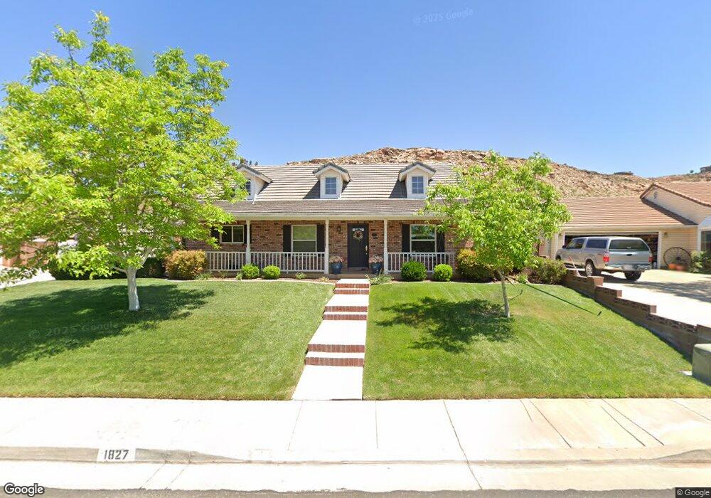
1827 S 1570 E Saint George, UT 84790
Estimated Value: $568,178 - $873,000
4
Beds
3
Baths
2,778
Sq Ft
$250/Sq Ft
Est. Value
About This Home
This home is located at 1827 S 1570 E, Saint George, UT 84790 and is currently estimated at $695,295, approximately $250 per square foot. 1827 S 1570 E is a home located in Washington County with nearby schools including Crimson View Elementary School, Crimson Cliffs Middle School, and Washington Fields Intermediate School.
Ownership History
Date
Name
Owned For
Owner Type
Purchase Details
Closed on
May 10, 2011
Sold by
Hoopes Daniel J and Hoopes Leanne
Bought by
Ross Nancy Norma
Current Estimated Value
Purchase Details
Closed on
May 9, 2011
Sold by
Ross Nancy Norma
Bought by
Ross Nancy Norma and Nancy Norma Ross Living Trust
Purchase Details
Closed on
Nov 24, 2010
Sold by
Colf Gary A and Colf Rebecca H
Bought by
Hoopes Daniel J and Hoopes Leanne
Home Financials for this Owner
Home Financials are based on the most recent Mortgage that was taken out on this home.
Original Mortgage
$140,000
Interest Rate
4.74%
Mortgage Type
Purchase Money Mortgage
Create a Home Valuation Report for This Property
The Home Valuation Report is an in-depth analysis detailing your home's value as well as a comparison with similar homes in the area
Purchase History
| Date | Buyer | Sale Price | Title Company |
|---|---|---|---|
| Ross Nancy Norma | -- | Terra Title St George Branch | |
| Ross Nancy Norma | -- | Accommodation | |
| Hoopes Daniel J | -- | Southern Utah Title | |
| Colf Gary A | -- | Southern Utah Title |
Source: Public Records
Mortgage History
| Date | Status | Borrower | Loan Amount |
|---|---|---|---|
| Previous Owner | Hoopes Daniel J | $140,000 |
Source: Public Records
Tax History
| Year | Tax Paid | Tax Assessment Tax Assessment Total Assessment is a certain percentage of the fair market value that is determined by local assessors to be the total taxable value of land and additions on the property. | Land | Improvement |
|---|---|---|---|---|
| 2025 | $2,054 | $328,515 | $110,715 | $217,800 |
| 2023 | $2,156 | $322,135 | $94,875 | $227,260 |
| 2022 | $2,830 | $326,150 | $80,850 | $245,300 |
| 2021 | $1,872 | $392,300 | $136,500 | $255,800 |
| 2020 | $1,703 | $336,100 | $94,500 | $241,600 |
| 2019 | $1,592 | $306,900 | $89,300 | $217,600 |
| 2018 | $1,587 | $153,340 | $0 | $0 |
| 2017 | $1,721 | $166,375 | $0 | $0 |
| 2016 | $1,749 | $156,310 | $0 | $0 |
| 2015 | $1,721 | $147,620 | $0 | $0 |
| 2014 | $1,707 | $147,290 | $0 | $0 |
Source: Public Records
Map
Nearby Homes
- 1648 Dihedral Dr
- 1560 E Dihedral Dr
- 1658 Schrund Cir Unit 80
- 1658 Schrund Cir Unit 75
- 1658 Schrund Cir Unit 74
- 1658 Schrund Cir Unit 73
- 1597 E Dihedral Dr
- 1606 Flat Rock Rd
- 1629 Flat Rock Rd
- 1596 E Talus Way
- 1790 S River Rd
- 1816 Boulder Cove Cir
- 2045 S 1400 E Unit 12
- 2045 S 1400 E Unit 13
- 2003 Opal Way
- 1620 E 1450 S Unit 37
- 1620 E 1450 S Unit 1
- 1620 E 1450 S Unit 79
- 2054 Topaz Way
- 1501 Boulder Mountain Rd
Your Personal Tour Guide
Ask me questions while you tour the home.