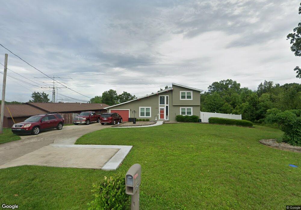
1828 Hill St Vine Grove, KY 40175
Estimated Value: $140,000 - $216,000
3
Beds
2
Baths
1,756
Sq Ft
$96/Sq Ft
Est. Value
About This Home
This home is located at 1828 Hill St, Vine Grove, KY 40175 and is currently estimated at $168,233, approximately $95 per square foot. 1828 Hill St is a home located in Hardin County with nearby schools including Meadow View Elementary School, North Middle School, and North Hardin High School.
Ownership History
Date
Name
Owned For
Owner Type
Purchase Details
Closed on
Dec 20, 2024
Sold by
Casey Linda L
Bought by
Armstrong Norman G and Armstrong Theresa M
Current Estimated Value
Purchase Details
Closed on
Sep 29, 2023
Sold by
Ketron Benny
Bought by
Armstrong Norman and Armstrong Theresa M
Purchase Details
Closed on
Jul 25, 2022
Sold by
Grounds Timothy J and Grounds Deborah
Bought by
Armstrong Norman and Armstrong Theresa M
Purchase Details
Closed on
Feb 22, 2022
Sold by
Real-Strong Properties Llc
Bought by
Armstrong Norman
Purchase Details
Closed on
Oct 2, 2012
Sold by
Fannie Mae
Bought by
Armstrong Norman and Armstrong Theresa
Home Financials for this Owner
Home Financials are based on the most recent Mortgage that was taken out on this home.
Original Mortgage
$97,420
Interest Rate
3.58%
Mortgage Type
Purchase Money Mortgage
Purchase Details
Closed on
Mar 9, 2012
Sold by
Little Jeanette
Bought by
Federal National Mortgage Association
Create a Home Valuation Report for This Property
The Home Valuation Report is an in-depth analysis detailing your home's value as well as a comparison with similar homes in the area
Home Values in the Area
Average Home Value in this Area
Purchase History
| Date | Buyer | Sale Price | Title Company |
|---|---|---|---|
| Armstrong Norman G | $130,600 | Bluegrass Land Title | |
| Armstrong Norman G | $130,600 | Bluegrass Land Title | |
| Armstrong Norman | $144,100 | Bluegrass Land Title | |
| Armstrong Norman | $122,000 | Bluegrass Land Title | |
| Armstrong Norman | $202,000 | Bluegrass Land Title | |
| Armstrong Norman | $62,000 | None Available | |
| Federal National Mortgage Association | $127,166 | None Available |
Source: Public Records
Mortgage History
| Date | Status | Borrower | Loan Amount |
|---|---|---|---|
| Previous Owner | Armstrong Norman | $97,420 |
Source: Public Records
Tax History Compared to Growth
Tax History
| Year | Tax Paid | Tax Assessment Tax Assessment Total Assessment is a certain percentage of the fair market value that is determined by local assessors to be the total taxable value of land and additions on the property. | Land | Improvement |
|---|---|---|---|---|
| 2025 | $98,700 | $147,800 | $15,000 | $132,800 |
| 2024 | $977 | $147,800 | $15,000 | $132,800 |
| 2023 | $114 | $125,200 | $13,300 | $111,900 |
| 2022 | $830 | $125,200 | $13,300 | $111,900 |
| 2021 | $917 | $125,200 | $13,300 | $111,900 |
| 2020 | $1,368 | $125,200 | $13,300 | $111,900 |
| 2019 | $194 | $124,200 | $0 | $0 |
| 2018 | $1,329 | $124,200 | $0 | $0 |
| 2017 | $1,323 | $124,200 | $0 | $0 |
| 2016 | $194 | $124,200 | $0 | $0 |
| 2015 | $799 | $124,200 | $0 | $0 |
| 2012 | -- | $128,000 | $0 | $0 |
Source: Public Records
Map
Nearby Homes
- 1362 Darlene Cir
- 1433 Crestview Dr
- 149 Red Hawk Dr
- Ashton Plan at Falcon Heights
- 1329 Bramblett Blvd
- 132 Red Hawk Dr
- 143 Red Hawk Dr
- 130 Red Hawk Dr
- 139 Red Hawk Dr
- 1474 Hill St
- 114 S Osprey Ct
- 128 Red Hawk Dr
- 126 Red Hawk Dr
- 1393 Kingswood Way
- 1465 Crestview Dr
- 1165 N Logsdon Pkwy
- 1058 Scenic Dr
- 119 Red Hawk Dr
- 1333 Kingswood Way
- 1435 Hawkins Dr
- 0 Safari Trail
- 1812 Hill St
- 1828 Hill St
- 20 Red Hill Rd
- 34 Safari Trail
- 1945 Hill St
- 21 Safari Trail
- 75 Safari Trail
- 75 Safari Trail Unit 8
- 74 Safari Trail
- 1890 Hill St
- 1919 Hill St
- 0000 Red Hill Rd
- 24 Red Hill Rd
- 67 Safari Trail
- 1945 Hill St
- Lot 2 Logsdon Cemetery Rd
- 4 Red Hill Rd
- 29 Red Hill Rd
- 1930 Hill St