
Seller's Agent in 2025
Julie Ahee
Sine & Monaghan LLC
(313) 300-9524
69 in this area
228 Total Sales
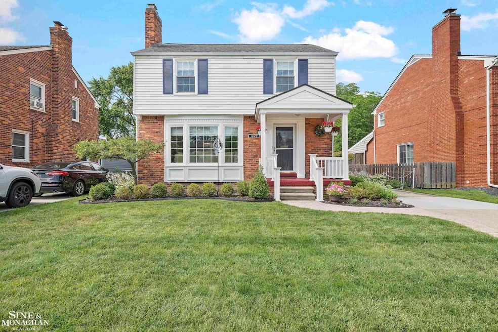
Welcome to this beautifully maintained and thoughtfully appointed home in Grosse Pointe Woods, ideally located in the Monteith and Grosse Pointe School Districts and just a short walk to shops and restaurants. The home’s excellent curb appeal invites you in to a spacious living and dining area featuring pristine hardwood floors, a gas fireplace, and newer windows throughout that bring in abundant natural light. The cozy family room overlooks the private, manicured backyard and opens to a stamped concrete patio—perfect for relaxing evenings or entertaining guests. The updated kitchen offers stainless steel appliances and generous cabinet space. Just off the family room, you'll find a beautifully renovated full bathroom, adding both function and flexibility to the first floor. Upstairs, you'll find three well-sized bedrooms and an updated hall bathroom. The finished lower level provides additional living space, an updated half bath, laundry area, and ample storage. A generous two-car garage offers even more storage space, ideal for a growing household. As a resident of Grosse Pointe, you’ll enjoy access to the private lakefront park featuring a pool, pickleball courts, marina, walking trails, and more. Welcome home!
Last Agent to Sell the Property
Sine & Monaghan LLC License #MISPE-6501323529 Listed on: 07/14/2025
| Date | Type | Sale Price | Title Company |
|---|---|---|---|
| Warranty Deed | $342,500 | Ata National Title | |
| Warranty Deed | $200,000 | Greco | |
| Deed | -- | -- |
| Date | Status | Loan Amount | Loan Type |
|---|---|---|---|
| Closed | -- | No Value Available |
| Date | Event | Price | List to Sale | Price per Sq Ft |
|---|---|---|---|---|
| 08/08/2025 08/08/25 | Sold | $342,500 | +4.1% | $220 / Sq Ft |
| 07/23/2025 07/23/25 | Pending | -- | -- | -- |
| 07/16/2025 07/16/25 | For Sale | $329,000 | -- | $212 / Sq Ft |
| Year | Tax Paid | Tax Assessment Tax Assessment Total Assessment is a certain percentage of the fair market value that is determined by local assessors to be the total taxable value of land and additions on the property. | Land | Improvement |
|---|---|---|---|---|
| 2025 | $2,292 | $142,400 | $0 | $0 |
| 2024 | $2,292 | $138,200 | $0 | $0 |
| 2023 | $2,204 | $126,600 | $0 | $0 |
| 2022 | $3,453 | $110,000 | $0 | $0 |
| 2021 | $3,291 | $103,200 | $0 | $0 |
| 2020 | $3,389 | $106,100 | $0 | $0 |
| 2019 | $2,007 | $101,900 | $0 | $0 |
| 2018 | $1,972 | $85,400 | $0 | $0 |
| 2017 | $2,292 | $82,800 | $0 | $0 |
| 2016 | $3,124 | $79,700 | $0 | $0 |
| 2015 | $5,415 | $70,600 | $0 | $0 |
| 2013 | $5,220 | $53,200 | $0 | $0 |
| 2012 | -- | $61,900 | $15,800 | $46,100 |
Seller's Agent in 2025
Julie Ahee
Sine & Monaghan LLC
(313) 300-9524
69 in this area
228 Total Sales
Buyer's Agent in 2025
Jimmy Saros
Jim Saros Real Estate Services
(313) 729-7857
31 in this area
234 Total Sales
Source: Michigan Multiple Listing Service
MLS Number: 50181572
APN: 40-011-04-0628-002
Disclaimer: Certain information contained herein is derived from information provided by parties other than Homes.com. All information provided is deemed reliable, but is not guaranteed to be accurate and should be independently verified.
![]() Source MLS: MiRealSource
Source MLS: MiRealSource
Provided through IDX via MiRealSource. Courtesy of MiRealSource Shareholder. Copyright MiRealSource.
The information published and disseminated by MiRealSource is communicated verbatim, without change by MiRealSource, as filed with MiRealSource by its members. The accuracy of all information, regardless of source, is not guaranteed or warranted. All information should be independently verified.
Copyright 2025 MiRealSource. All rights reserved. The information provided hereby constitutes proprietary information of MiRealSource, Inc. and its shareholders, affiliates and licensees and may not be reproduced or transmitted in any form or by any means, electronic or mechanical, including photocopy, recording, scanning or any information storage and retrieval system, without written permission from MiRealSource, Inc.