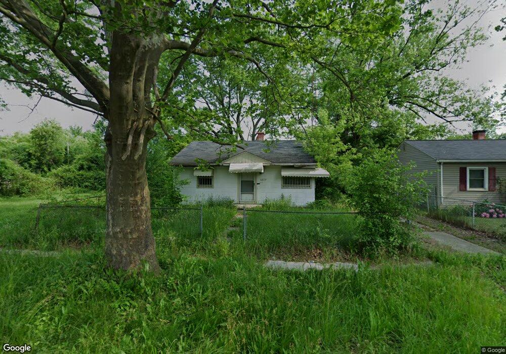
1829 Polly St Flint, MI 48505
Northeast Village NeighborhoodEstimated Value: $37,000 - $41,000
3
Beds
1
Bath
900
Sq Ft
$43/Sq Ft
Est. Value
About This Home
This home is located at 1829 Polly St, Flint, MI 48505 and is currently estimated at $38,333, approximately $42 per square foot. 1829 Polly St is a home located in Genesee County with nearby schools including Brownell STEM Academy, The New Standard Academy, and Richfield Public School Academy.
Ownership History
Date
Name
Owned For
Owner Type
Purchase Details
Closed on
Dec 19, 2023
Sold by
Genesee County Treasurer
Bought by
Genesee Cnty Land Bk Authority
Current Estimated Value
Purchase Details
Closed on
Sep 22, 2008
Sold by
Real Estate Network
Bought by
Price Le Void
Purchase Details
Closed on
Feb 4, 2002
Sold by
Hud
Bought by
Bates Tolerun
Purchase Details
Closed on
Jul 2, 2001
Sold by
Benchmark Mtg Corp
Bought by
Hud
Purchase Details
Closed on
May 24, 2001
Sold by
Wilson Scott
Bought by
Benchmark Mtg Corp
Create a Home Valuation Report for This Property
The Home Valuation Report is an in-depth analysis detailing your home's value as well as a comparison with similar homes in the area
Home Values in the Area
Average Home Value in this Area
Purchase History
| Date | Buyer | Sale Price | Title Company |
|---|---|---|---|
| Genesee Cnty Land Bk Authority | -- | None Listed On Document | |
| Price Le Void | -- | None Available | |
| Bates Tolerun | $5,550 | -- | |
| Hud | -- | -- | |
| Benchmark Mtg Corp | $19,429 | -- |
Source: Public Records
Tax History Compared to Growth
Tax History
| Year | Tax Paid | Tax Assessment Tax Assessment Total Assessment is a certain percentage of the fair market value that is determined by local assessors to be the total taxable value of land and additions on the property. | Land | Improvement |
|---|---|---|---|---|
| 2025 | -- | $0 | $0 | $0 |
| 2024 | $499 | $0 | $0 | $0 |
| 2023 | $478 | $7,300 | $0 | $0 |
| 2022 | $0 | $6,200 | $0 | $0 |
| 2021 | $477 | $5,900 | $0 | $0 |
| 2020 | $454 | $4,000 | $0 | $0 |
| 2019 | $455 | $4,000 | $0 | $0 |
| 2018 | $412 | $4,100 | $0 | $0 |
| 2017 | $541 | $0 | $0 | $0 |
| 2016 | $404 | $0 | $0 | $0 |
| 2015 | -- | $0 | $0 | $0 |
| 2014 | -- | $0 | $0 | $0 |
| 2012 | -- | $3,600 | $0 | $0 |
Source: Public Records
Map
Nearby Homes
- 1704 E Webster Rd
- 5910 N Dort Hwy
- 5919 Western Rd
- E E Carpenter Rd
- 1218 E Piper Ave
- 2910 Hampstead Dr
- 5501 Western Rd
- 5220 Western Rd
- 2710 Eaton Place
- 2802 Eaton Place
- 4923 Alpha Way
- 1320 E Cornell Ave
- 946 E Bundy Ave
- 2801 Epsilon Trail
- 1404 E Kurtz Ave
- 4907 Delta Dr
- 802 E Russell Ave
- 3009 Plainfield Ave
- 1151 E Cornell Ave
- 738 E York Ave