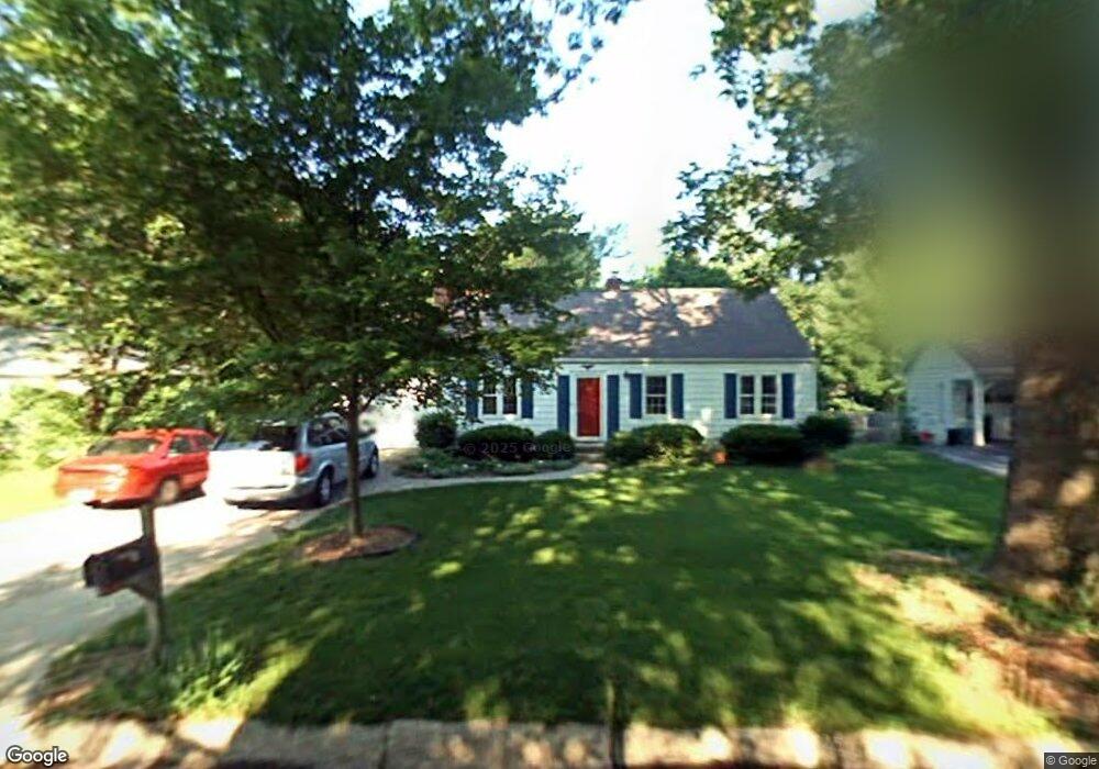
1829 Summit Dr West Lafayette, IN 47906
Estimated Value: $356,637 - $383,000
--
Bed
1
Bath
2,028
Sq Ft
$182/Sq Ft
Est. Value
About This Home
This home is located at 1829 Summit Dr, West Lafayette, IN 47906 and is currently estimated at $369,159, approximately $182 per square foot. 1829 Summit Dr is a home located in Tippecanoe County with nearby schools including West Lafayette Intermediate School, West Lafayette Elementary School, and West Lafayette Junior/Senior High School.
Ownership History
Date
Name
Owned For
Owner Type
Purchase Details
Closed on
Jul 21, 2005
Sold by
Morgan Gregory A and Morgan Stacey A
Bought by
Boerrigter Stephan X M and Roos Ginette
Current Estimated Value
Home Financials for this Owner
Home Financials are based on the most recent Mortgage that was taken out on this home.
Original Mortgage
$111,920
Outstanding Balance
$57,325
Interest Rate
5.37%
Mortgage Type
Fannie Mae Freddie Mac
Estimated Equity
$311,834
Purchase Details
Closed on
Jun 7, 2001
Sold by
Finke Roger K and Finke Teresa J
Bought by
Morgan Gregory A and Morgan Stacey A
Home Financials for this Owner
Home Financials are based on the most recent Mortgage that was taken out on this home.
Original Mortgage
$119,000
Interest Rate
5.5%
Create a Home Valuation Report for This Property
The Home Valuation Report is an in-depth analysis detailing your home's value as well as a comparison with similar homes in the area
Home Values in the Area
Average Home Value in this Area
Purchase History
| Date | Buyer | Sale Price | Title Company |
|---|---|---|---|
| Boerrigter Stephan X M | -- | -- | |
| Morgan Gregory A | -- | -- |
Source: Public Records
Mortgage History
| Date | Status | Borrower | Loan Amount |
|---|---|---|---|
| Open | Boerrigter Stephan X M | $111,920 | |
| Previous Owner | Morgan Gregory A | $119,000 |
Source: Public Records
Tax History Compared to Growth
Tax History
| Year | Tax Paid | Tax Assessment Tax Assessment Total Assessment is a certain percentage of the fair market value that is determined by local assessors to be the total taxable value of land and additions on the property. | Land | Improvement |
|---|---|---|---|---|
| 2024 | $3,259 | $273,700 | $84,800 | $188,900 |
| 2023 | $2,700 | $235,500 | $55,000 | $180,500 |
| 2022 | $2,541 | $213,300 | $55,000 | $158,300 |
| 2021 | $2,292 | $193,200 | $55,000 | $138,200 |
| 2020 | $2,125 | $179,800 | $55,000 | $124,800 |
| 2019 | $2,049 | $173,500 | $55,000 | $118,500 |
| 2018 | $1,673 | $144,600 | $32,000 | $112,600 |
| 2017 | $3,305 | $139,400 | $32,000 | $107,400 |
| 2016 | $1,418 | $134,300 | $30,600 | $103,700 |
| 2014 | $1,308 | $124,800 | $30,600 | $94,200 |
| 2013 | $1,232 | $123,700 | $30,600 | $93,100 |
Source: Public Records
Map
Nearby Homes
- 1190 Camelback Blvd
- 2212 Sycamore Ln
- 2306 Carmel Dr
- 701 Carrolton Blvd
- 1912 Indian Trail Dr
- 500 Carrolton Blvd
- 509 Carrolton Blvd
- 1220 Ravinia Rd
- 1744 Sandpiper Dr
- 208 W Navajo St
- 631 Kent Ave
- 2843 Barlow St
- 448 Westview Cir
- 2825 Henderson St
- 2861 Linda Ln W
- 1044 Roxboro St
- 416 Catherwood Dr
- 1868 N River Rd
- 218 Myrtle Dr
- 845 Rose St
- 1833 Summit Dr
- 1825 Summit Dr
- 1834 Sheridan Rd
- 1837 Summit Dr
- 1830 Sheridan Rd
- 1838 Sheridan Rd
- 1821 Summit Dr
- 1824 Sheridan Rd
- 1830 Summit Dr
- 1842 Sheridan Rd
- 1824 Summit Dr
- 1820 Sheridan Rd
- 1815 Summit Dr
- 1820 Summit Dr
- 1217 Lindberg Rd
- 1111 Lindberg Rd
- 1814 Sheridan Rd
- 1816 Summit Dr
- 1809 Summit Dr
- 1837 Sheridan Rd