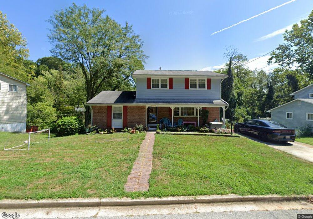
1829 Taylor Ave Fort Washington, MD 20744
Estimated Value: $460,468 - $500,000
4
Beds
3
Baths
3,044
Sq Ft
$158/Sq Ft
Est. Value
About This Home
This home is located at 1829 Taylor Ave, Fort Washington, MD 20744 and is currently estimated at $480,867, approximately $157 per square foot. 1829 Taylor Ave is a home located in Prince George's County with nearby schools including Fort Washington Forest Elementary School, Accokeek Academy, and Friendly High School.
Ownership History
Date
Name
Owned For
Owner Type
Purchase Details
Closed on
Jan 17, 2018
Sold by
Rankin Aishia C and Wright Aisha C
Bought by
Rankin Aishia C and Rankin York T
Current Estimated Value
Home Financials for this Owner
Home Financials are based on the most recent Mortgage that was taken out on this home.
Original Mortgage
$232,651
Outstanding Balance
$197,863
Interest Rate
4.25%
Mortgage Type
FHA
Estimated Equity
$283,004
Purchase Details
Closed on
May 20, 2011
Sold by
Frazier John W and Frazier Mary Ann
Bought by
Wright Aishia C
Home Financials for this Owner
Home Financials are based on the most recent Mortgage that was taken out on this home.
Original Mortgage
$202,276
Interest Rate
4.85%
Mortgage Type
FHA
Purchase Details
Closed on
May 2, 1968
Sold by
Graham Robt B and Graham Je
Bought by
Frazier John W and Frazier Mary A
Create a Home Valuation Report for This Property
The Home Valuation Report is an in-depth analysis detailing your home's value as well as a comparison with similar homes in the area
Home Values in the Area
Average Home Value in this Area
Purchase History
| Date | Buyer | Sale Price | Title Company |
|---|---|---|---|
| Rankin Aishia C | -- | Carrington Title Svcs Llc | |
| Wright Aishia C | $205,000 | First American Title Ins Co | |
| Frazier John W | $26,900 | -- |
Source: Public Records
Mortgage History
| Date | Status | Borrower | Loan Amount |
|---|---|---|---|
| Open | Rankin Aishia C | $232,651 | |
| Closed | Wright Aishia C | $5,000 | |
| Previous Owner | Wright Aishia C | $202,276 |
Source: Public Records
Tax History Compared to Growth
Tax History
| Year | Tax Paid | Tax Assessment Tax Assessment Total Assessment is a certain percentage of the fair market value that is determined by local assessors to be the total taxable value of land and additions on the property. | Land | Improvement |
|---|---|---|---|---|
| 2025 | $4,614 | $362,300 | -- | -- |
| 2024 | $4,614 | $330,900 | $101,700 | $229,200 |
| 2023 | $4,520 | $327,333 | $0 | $0 |
| 2022 | $4,382 | $323,767 | $0 | $0 |
| 2021 | $4,250 | $320,200 | $100,800 | $219,400 |
| 2020 | $4,169 | $308,300 | $0 | $0 |
| 2019 | $4,067 | $296,400 | $0 | $0 |
| 2018 | $3,922 | $284,500 | $75,800 | $208,700 |
| 2017 | $3,757 | $259,667 | $0 | $0 |
| 2016 | -- | $234,833 | $0 | $0 |
| 2015 | $3,413 | $210,000 | $0 | $0 |
| 2014 | $3,413 | $210,000 | $0 | $0 |
Source: Public Records
Map
Nearby Homes
- 1916 Taylor Ave
- 13318 Chalfont Ave
- 1410 Fillmore Rd
- 13503 Harrison Ave
- 12904 Chalfont Ave
- 12806 Monroe Ave
- 14005 Livingston Rd
- 2421 Baileys Pond Rd
- 0 Joseph Dr
- 13102 Gerry Rd
- 2608 Saint Marys View Rd
- 2001 Medinah Ridge Rd
- 2201 Herring Creek Dr
- 804 Cascade Dr
- 802 Cornish St
- 14311 Livingston Rd
- 13803 Stroh Ct
- 13303 Pendleton St
- 13403 Pendleton St
- 2504 Brandy Ln
- 1827 Taylor Ave
- 1833 Taylor Ave
- 1825 Taylor Ave
- 1832 Taylor Ave
- 1909 Taylor Ave
- 1828 Taylor Ave
- 1905 Taylor Ave
- 1911 Taylor Ave
- 1834 Taylor Ave
- 1826 Taylor Ave
- 1823 Taylor Ave
- 1913 Taylor Ave
- 1830 Taylor Ave
- 1824 Taylor Ave
- 1821 Taylor Ave
- 1915 Taylor Ave
- 13402 Taylor Ct
- 1836 Taylor Ave
- 1822 Taylor Ave
- 1900 Taylor Ave