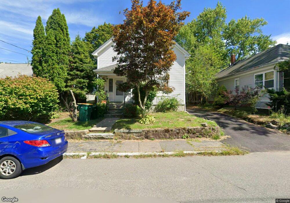
183 Broad St North Attleboro, MA 02760
North Attleboro NeighborhoodEstimated Value: $412,000 - $536,000
4
Beds
2
Baths
1,331
Sq Ft
$345/Sq Ft
Est. Value
About This Home
This home is located at 183 Broad St, North Attleboro, MA 02760 and is currently estimated at $459,589, approximately $345 per square foot. 183 Broad St is a home located in Bristol County with nearby schools including North Attleboro High School and Cadence Academy Preschool - North Attleborough.
Ownership History
Date
Name
Owned For
Owner Type
Purchase Details
Closed on
Nov 10, 2008
Sold by
Robinson Stephen L
Bought by
Nakhla Nabil N and Said Sabrin
Current Estimated Value
Home Financials for this Owner
Home Financials are based on the most recent Mortgage that was taken out on this home.
Original Mortgage
$169,360
Outstanding Balance
$111,172
Interest Rate
6.08%
Mortgage Type
Purchase Money Mortgage
Estimated Equity
$348,417
Purchase Details
Closed on
Apr 1, 1999
Sold by
Messier George W and Messier Kathleen B
Bought by
Robinson Stephen L
Home Financials for this Owner
Home Financials are based on the most recent Mortgage that was taken out on this home.
Original Mortgage
$112,100
Interest Rate
6.78%
Mortgage Type
Purchase Money Mortgage
Create a Home Valuation Report for This Property
The Home Valuation Report is an in-depth analysis detailing your home's value as well as a comparison with similar homes in the area
Home Values in the Area
Average Home Value in this Area
Purchase History
| Date | Buyer | Sale Price | Title Company |
|---|---|---|---|
| Nakhla Nabil N | $174,600 | -- | |
| Robinson Stephen L | $118,000 | -- |
Source: Public Records
Mortgage History
| Date | Status | Borrower | Loan Amount |
|---|---|---|---|
| Open | Robinson Stephen L | $30,400 | |
| Open | Nakhla Nabil N | $169,360 | |
| Previous Owner | Robinson Stephen L | $170,000 | |
| Previous Owner | Robinson Stephen L | $112,100 |
Source: Public Records
Tax History Compared to Growth
Tax History
| Year | Tax Paid | Tax Assessment Tax Assessment Total Assessment is a certain percentage of the fair market value that is determined by local assessors to be the total taxable value of land and additions on the property. | Land | Improvement |
|---|---|---|---|---|
| 2025 | $4,184 | $354,900 | $98,200 | $256,700 |
| 2024 | $3,989 | $345,700 | $98,200 | $247,500 |
| 2023 | $3,869 | $302,500 | $98,200 | $204,300 |
| 2022 | $3,839 | $275,600 | $98,200 | $177,400 |
| 2021 | $5,055 | $242,800 | $98,200 | $144,600 |
| 2020 | $4,755 | $239,300 | $98,200 | $141,100 |
| 2019 | $4,586 | $224,700 | $89,300 | $135,400 |
| 2018 | $4,108 | $213,100 | $89,300 | $123,800 |
| 2017 | $3,842 | $201,600 | $89,300 | $112,300 |
| 2016 | $2,537 | $191,900 | $99,200 | $92,700 |
| 2015 | $2,435 | $185,300 | $104,100 | $81,200 |
| 2014 | $2,457 | $185,600 | $96,300 | $89,300 |
Source: Public Records
Map
Nearby Homes
- 20 South St
- 35-R Whiting St
- 64 Smith St
- 45 Moran St
- 68 Fisher St
- 8 Al Pace Dr Unit 8
- 188 Smith St
- 19 Church St Unit A5
- 212 Fisher St Unit A5
- 1066 Mount Hope St
- 217 Fisher St
- 16 Elizabeth St
- 16 Richards Ave Unit 106
- 85 Richards Ave
- 0 Landry 2nd Unit 73350867
- 93 Bank St
- 880 Landry Ave Unit 2
- 42 2nd Ave Unit 24
- 99 Arnold Rd
- 20 Holbrook Ave
- 185 Broad St
- 177 Broad St
- 12 Horne St
- 189 Broad St
- 189 Broad St Unit 2
- 189 Broad St Unit 1
- 189 Broad St Unit 3
- 16 Horne St
- 171 Broad St
- 176 Broad St
- 15 Adams St
- 193 Broad St
- 195 Broad St
- 193 Broad St Unit 2
- 193 Broad St Unit 1
- 188 Broad St
- 188 Broad St Unit 1
- 188 Broad St Unit 2
- 188 Broad St Unit 3
- 24 Horne St