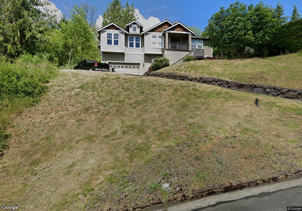
183 Curtis Dr Longview, WA 98632
Hillside Acres NeighborhoodEstimated Value: $588,757 - $641,000
3
Beds
3
Baths
2,256
Sq Ft
$273/Sq Ft
Est. Value
About This Home
This home is located at 183 Curtis Dr, Longview, WA 98632 and is currently estimated at $616,439, approximately $273 per square foot. 183 Curtis Dr is a home located in Cowlitz County with nearby schools including Columbia Valley Gardens Elementary School, Cascade Middle School, and Mark Morris High School.
Ownership History
Date
Name
Owned For
Owner Type
Purchase Details
Closed on
Dec 10, 2007
Sold by
Colton Jared and Colton Gina
Bought by
Rismoen Lonnie L
Current Estimated Value
Home Financials for this Owner
Home Financials are based on the most recent Mortgage that was taken out on this home.
Original Mortgage
$278,400
Outstanding Balance
$175,851
Interest Rate
6.26%
Mortgage Type
Purchase Money Mortgage
Estimated Equity
$440,588
Purchase Details
Closed on
Sep 12, 2006
Sold by
Stovall Marshall E and Stovall Amanda C
Bought by
Colton Jared and Colton Gina
Home Financials for this Owner
Home Financials are based on the most recent Mortgage that was taken out on this home.
Original Mortgage
$271,100
Interest Rate
6.56%
Mortgage Type
Purchase Money Mortgage
Purchase Details
Closed on
Nov 30, 2005
Sold by
Stone Susan K and Pellham Susan K
Bought by
Stovall Marshall E and Stovall Amanda C
Create a Home Valuation Report for This Property
The Home Valuation Report is an in-depth analysis detailing your home's value as well as a comparison with similar homes in the area
Home Values in the Area
Average Home Value in this Area
Purchase History
| Date | Buyer | Sale Price | Title Company |
|---|---|---|---|
| Rismoen Lonnie L | $310,000 | Cowlitz County Title Company | |
| Colton Jared | $48,000 | Chicago Title Ins | |
| Stovall Marshall E | $42,000 | Chicago Title Ins |
Source: Public Records
Mortgage History
| Date | Status | Borrower | Loan Amount |
|---|---|---|---|
| Open | Rismoen Lonnie L | $278,400 | |
| Previous Owner | Colton Jared | $271,100 |
Source: Public Records
Tax History Compared to Growth
Tax History
| Year | Tax Paid | Tax Assessment Tax Assessment Total Assessment is a certain percentage of the fair market value that is determined by local assessors to be the total taxable value of land and additions on the property. | Land | Improvement |
|---|---|---|---|---|
| 2024 | $5,107 | $624,870 | $44,010 | $580,860 |
| 2023 | $4,910 | $602,980 | $44,010 | $558,970 |
| 2022 | $4,913 | $657,870 | $44,010 | $613,860 |
| 2021 | $4,645 | $516,210 | $44,010 | $472,200 |
| 2020 | $4,117 | $437,680 | $44,010 | $393,670 |
| 2019 | $3,766 | $405,196 | $43,969 | $361,227 |
| 2018 | $4,133 | $363,640 | $43,970 | $319,670 |
| 2017 | $3,504 | $325,950 | $41,880 | $284,070 |
| 2016 | $3,203 | $280,360 | $38,070 | $242,290 |
| 2015 | $3,374 | $261,190 | $38,070 | $223,120 |
| 2013 | -- | $253,390 | $48,090 | $205,300 |
Source: Public Records
Map
Nearby Homes
- 9 Curtis Ln
- 0 Sunset Way Unit 777828686
- 0 Sunset Way Unit NWM2435557
- 4415 Poplar Way
- 4057 Sunset Way
- 4043 Sunset Way
- 104 Terumi Ln
- 4411 Pennsylvania St
- 3541 Fairway Ln
- 5 Crestmont Ave
- 132 Lone Oak Rd
- 162 Monticello Dr
- 2820 36th Ave
- 187 Acorn Ln
- 3652 Pennsylvania St
- 3620 Pennsylvania St
- 3618 Pennsylvania St
- 3632 Pennsylvania St
- 3749 Rosewood St
- 3721 Columbia Heights Rd