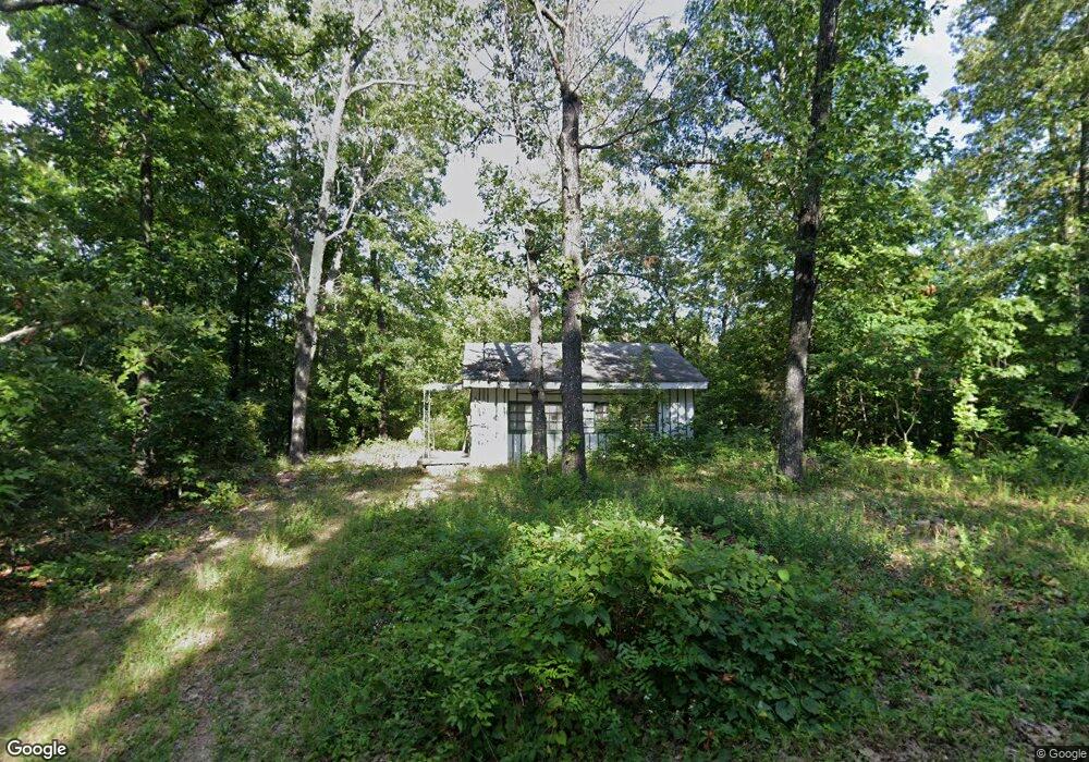
183 Deer Run Dr Cherokee Village, AR 72529
Estimated Value: $49,000 - $102,000
--
Bed
1
Bath
624
Sq Ft
$134/Sq Ft
Est. Value
About This Home
This home is located at 183 Deer Run Dr, Cherokee Village, AR 72529 and is currently estimated at $83,750, approximately $134 per square foot. 183 Deer Run Dr is a home located in Sharp County with nearby schools including Cherokee Elementary School, Highland Middle School, and Highland High School.
Ownership History
Date
Name
Owned For
Owner Type
Purchase Details
Closed on
May 9, 2024
Sold by
American Land Company Llc
Bought by
Alwin Robert
Current Estimated Value
Purchase Details
Closed on
Aug 4, 2022
Sold by
Commissioner Of State Lands
Bought by
American Land Company Llc
Purchase Details
Closed on
May 16, 2022
Sold by
Circuit Comissioner and Circuit Court
Bought by
Board Of Country Commissioners
Create a Home Valuation Report for This Property
The Home Valuation Report is an in-depth analysis detailing your home's value as well as a comparison with similar homes in the area
Home Values in the Area
Average Home Value in this Area
Purchase History
| Date | Buyer | Sale Price | Title Company |
|---|---|---|---|
| Alwin Robert | -- | None Listed On Document | |
| Alwin Robert | -- | None Listed On Document | |
| American Land Company Llc | $351 | -- | |
| Board Of Country Commissioners | -- | None Listed On Document |
Source: Public Records
Tax History Compared to Growth
Tax History
| Year | Tax Paid | Tax Assessment Tax Assessment Total Assessment is a certain percentage of the fair market value that is determined by local assessors to be the total taxable value of land and additions on the property. | Land | Improvement |
|---|---|---|---|---|
| 2024 | $232 | $5,670 | $500 | $5,170 |
| 2023 | $232 | $5,670 | $500 | $5,170 |
| 2022 | $231 | $3,450 | $500 | $2,950 |
| 2021 | $228 | $3,450 | $500 | $2,950 |
| 2020 | $460 | $3,450 | $500 | $2,950 |
| 2019 | $449 | $2,830 | $500 | $2,330 |
| 2018 | $449 | $2,830 | $500 | $2,330 |
| 2017 | $107 | $2,830 | $500 | $2,330 |
| 2016 | $238 | $2,830 | $500 | $2,330 |
| 2015 | -- | $2,830 | $500 | $2,330 |
| 2014 | -- | $3,340 | $500 | $2,840 |
| 2013 | -- | $3,340 | $500 | $2,840 |
Source: Public Records
Map
Nearby Homes
- L10, B01 Hiawatha Dr
- L-11 & 12, B17 Hiawatha Dr
- 160 Hiawatha Dr
- L-11, B-2 Yuma Trail
- 212 Hiawatha Dr
- 0 Tsexeki Dr
- L-4, B-6 Chickasaw Dr
- 9 Chickasaw Dr
- 0 Sioux Dr Unit 24013836
- L-30 B-1 Sioux Dr
- 16 Shoshone Cir
- 22 S Wichita Cir
- Lots 18-19 Sequoyah Ridge Rd
- Lot 27 Sequoyah Ridge Rd
- Lot 16 Sequoyah Ridge Rd
- Lot 15 Sequoyah Ridge Rd
- Lot 6 Sequoyah Ridge Rd
- Lot 11-3 Sequoyah Ridge Rd
- TBD Deer Run Dr
- 130 Hiawatha Dr
- 189 Deer Run Dr
- 47 Sioux Dr
- 184 Deer Run Dr
- 209 Hiawatha Dr
- 195 Deer Run Dr
- 197 Hiawatha Dr
- 197 Deer Run Dr
- 0 Deer Run
- 195 Hiawatha Dr
- 67 Geronimo Dr
- 193 Hiawatha Dr
- 172 Hiawatha Dr
- 178 Hiawatha Dr
- 1 Raccoon Cir
- 191 Hiawatha Dr
- 176 Deer Run Dr
- 91 S Apache Dr
- 166 Hiawatha Dr
- 174 Deer Run Dr
- 164 Hiawatha Dr