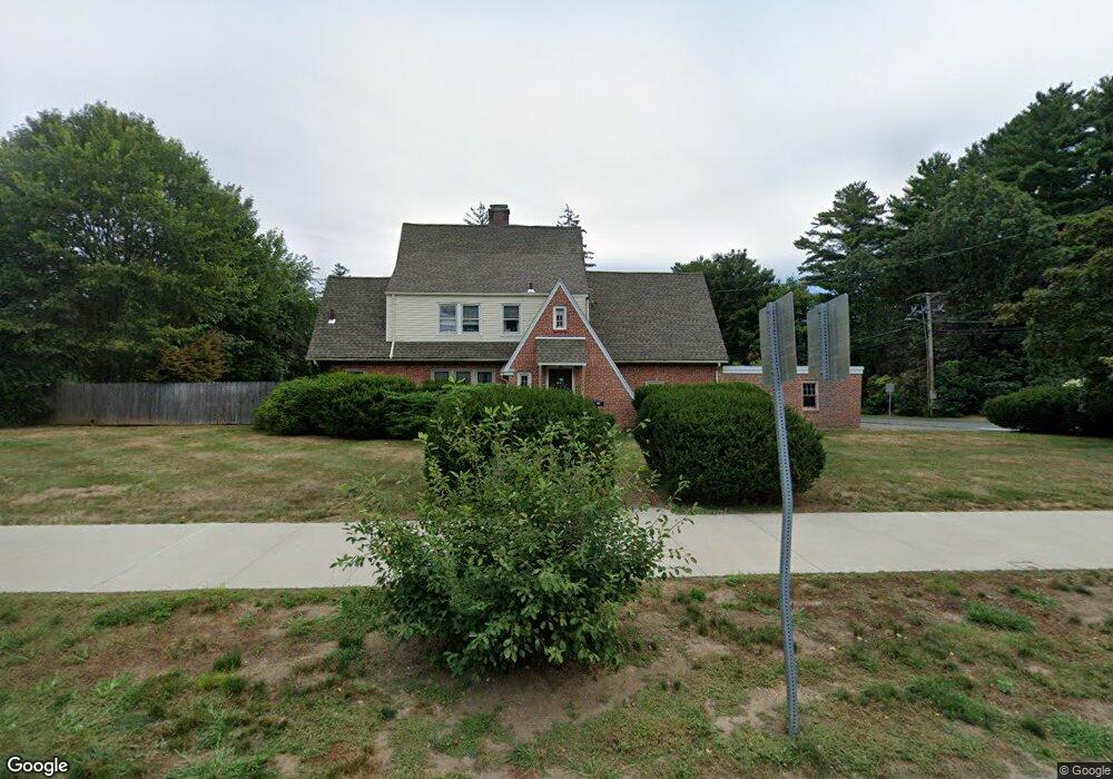
183 Western Ave Westfield, MA 01085
Estimated Value: $503,000 - $613,000
4
Beds
4
Baths
3,220
Sq Ft
$173/Sq Ft
Est. Value
About This Home
This home is located at 183 Western Ave, Westfield, MA 01085 and is currently estimated at $556,077, approximately $172 per square foot. 183 Western Ave is a home located in Hampden County with nearby schools including Westfield High School and Saint Mary High School.
Ownership History
Date
Name
Owned For
Owner Type
Purchase Details
Closed on
Sep 27, 1993
Sold by
Cerveny Joann E
Bought by
Ouimette Anne M
Current Estimated Value
Home Financials for this Owner
Home Financials are based on the most recent Mortgage that was taken out on this home.
Original Mortgage
$169,600
Interest Rate
7.1%
Mortgage Type
Purchase Money Mortgage
Create a Home Valuation Report for This Property
The Home Valuation Report is an in-depth analysis detailing your home's value as well as a comparison with similar homes in the area
Home Values in the Area
Average Home Value in this Area
Purchase History
| Date | Buyer | Sale Price | Title Company |
|---|---|---|---|
| Ouimette Anne M | $212,000 | -- |
Source: Public Records
Mortgage History
| Date | Status | Borrower | Loan Amount |
|---|---|---|---|
| Open | Ouimette Anne M | $150,000 | |
| Closed | Ouimette Anne M | $169,600 | |
| Previous Owner | Ouimette Anne M | $100,000 |
Source: Public Records
Tax History Compared to Growth
Tax History
| Year | Tax Paid | Tax Assessment Tax Assessment Total Assessment is a certain percentage of the fair market value that is determined by local assessors to be the total taxable value of land and additions on the property. | Land | Improvement |
|---|---|---|---|---|
| 2025 | $6,778 | $446,500 | $139,300 | $307,200 |
| 2024 | $6,806 | $426,200 | $127,100 | $299,100 |
| 2023 | $6,584 | $384,900 | $121,000 | $263,900 |
| 2022 | $6,303 | $340,900 | $107,500 | $233,400 |
| 2021 | $6,117 | $324,000 | $101,400 | $222,600 |
| 2020 | $5,925 | $307,800 | $101,400 | $206,400 |
| 2019 | $4,021 | $294,900 | $96,600 | $198,300 |
| 2018 | $4,267 | $294,900 | $96,600 | $198,300 |
| 2017 | $5,593 | $288,000 | $97,900 | $190,100 |
| 2016 | $5,599 | $288,000 | $97,900 | $190,100 |
| 2015 | $5,139 | $277,200 | $97,900 | $179,300 |
| 2014 | $3,846 | $277,200 | $97,900 | $179,300 |
Source: Public Records
Map
Nearby Homes
- 324 Russell Rd Unit 204
- 11 Highland Cir
- 78 Granville Rd Unit 11
- 508 Granville Rd
- 549 Russell Rd Unit 6B
- 128 Crane Ave
- 555 Russell Rd Unit D18
- 0 Fox Hill Dr
- 40 Heritage Ln
- 53 Yankee Cir
- 291 Pochassic Rd
- 14 Pinewood Ln
- 13 King Place
- 113 Franklin St
- 172 Valley View Dr
- 15 Bates St
- 148 Prospect Street Extension
- 8 Ellis St
- 82 S Maple St Unit 11
- 82 S Maple St Unit 43
- 0 Broadway Unit 71740034
- 191 Western Ave
- 9 Broadway
- 176 Western Ave
- 165 Western Ave
- 20 Mountain View St
- 194 Western Ave
- 164 Western Ave
- 11 Lloyds Hill Rd
- 2 Woodland Rd
- 9 Fairview Ave
- 20 Broadway
- 15 Broadway
- 30 Mountain View St
- 206 Western Ave
- 15 Fairview Ave
- 153 Western Ave
- 156 Western Ave
- 15 Mountain View St
- 217 Western Ave