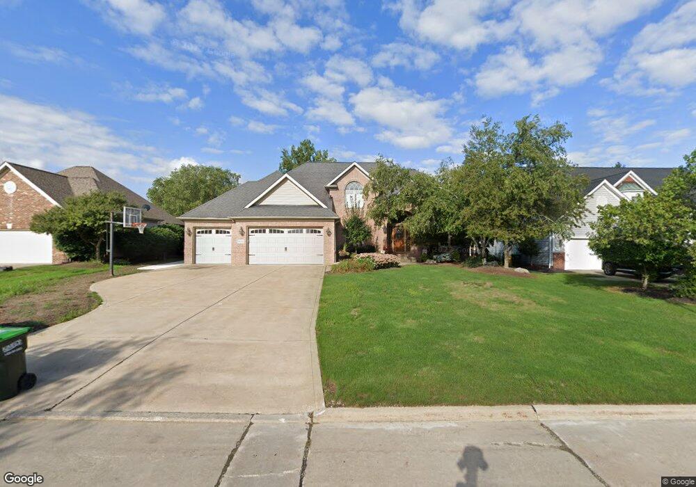
1830 Cedarhurst Dr Wickliffe, OH 44092
Estimated Value: $395,000 - $559,313
4
Beds
5
Baths
2,167
Sq Ft
$215/Sq Ft
Est. Value
About This Home
This home is located at 1830 Cedarhurst Dr, Wickliffe, OH 44092 and is currently estimated at $464,828, approximately $214 per square foot. 1830 Cedarhurst Dr is a home located in Lake County with nearby schools including Wickliffe Elementary School, Wickliffe Middle School, and Wickliffe High School.
Ownership History
Date
Name
Owned For
Owner Type
Purchase Details
Closed on
Sep 17, 1997
Sold by
Silva Laurel A
Bought by
Camino Carmen D and Camino Charlene
Current Estimated Value
Purchase Details
Closed on
Jun 4, 1997
Sold by
Sorine Anthony P
Bought by
Silva Laurel A
Purchase Details
Closed on
Aug 6, 1991
Bought by
Sorine Anthony P
Create a Home Valuation Report for This Property
The Home Valuation Report is an in-depth analysis detailing your home's value as well as a comparison with similar homes in the area
Home Values in the Area
Average Home Value in this Area
Purchase History
| Date | Buyer | Sale Price | Title Company |
|---|---|---|---|
| Camino Carmen D | $85,000 | Commonwealth Land Title Agen | |
| Silva Laurel A | $84,500 | Commonwealth Land Title Agen | |
| Sorine Anthony P | $65,000 | -- |
Source: Public Records
Tax History
| Year | Tax Paid | Tax Assessment Tax Assessment Total Assessment is a certain percentage of the fair market value that is determined by local assessors to be the total taxable value of land and additions on the property. | Land | Improvement |
|---|---|---|---|---|
| 2025 | -- | $174,940 | $32,930 | $142,010 |
| 2024 | -- | $174,940 | $32,930 | $142,010 |
| 2023 | $18,515 | $150,550 | $27,900 | $122,650 |
| 2022 | $10,412 | $150,550 | $27,900 | $122,650 |
| 2021 | $10,455 | $145,130 | $27,900 | $117,230 |
| 2020 | $10,084 | $118,960 | $22,870 | $96,090 |
| 2019 | $10,080 | $118,960 | $22,870 | $96,090 |
| 2018 | $8,686 | $102,460 | $34,050 | $68,410 |
| 2017 | $7,217 | $102,460 | $34,050 | $68,410 |
| 2016 | $7,182 | $102,460 | $34,050 | $68,410 |
| 2015 | $7,055 | $102,460 | $34,050 | $68,410 |
| 2014 | $6,215 | $102,460 | $34,050 | $68,410 |
| 2013 | $6,212 | $102,460 | $34,050 | $68,410 |
Source: Public Records
Map
Nearby Homes
- 5642 Grand Place
- 30530 Grant St
- 5430 Oak Ridge Dr
- 1677 Mapledale Rd
- 30529 Ridge Rd
- 1842 Eldon Dr
- 1677 Douglas Rd
- 5485 Wildwood Ct Unit D
- 5481 Millwood Ln Unit C
- 1648 Douglas Rd
- 5548 Ivy Ct Unit C
- 5463 Millwood Ln Unit 42C
- 5512 Sutton Ln Unit D
- 5520 Bretton Ct Unit A
- 5542 Bretton Ct Unit A
- 30200 Ridge Rd
- 1554 Rush Rd
- 5444 Som Center Rd
- 1719 E 300th St
- 1522 Mapledale Rd
- 1838 Cedarhurst Dr
- 1820 Cedarhurst Dr
- 1846 Cedarhurst Dr
- 1808 Cedarhurst Dr
- 1854 Cedarhurst Dr
- 1831 Cedarhurst Dr
- 1837 Cedarhurst Dr
- 1821 Cedarhurst Dr
- 1847 Cedarhurst Dr
- 1800 Cedarhurst Dr
- 1862 Cedarhurst Dr
- 1809 Cedarhurst Dr
- 1855 Cedarhurst Dr
- 1801 Cedarhurst Dr
- 1870 Cedarhurst Dr
- 1861 Cedarhurst Dr
- 1805 Cedarhurst Dr
- 1878 Cedarhurst Dr
- 1886 Cedarhurst Dr
- 1894 Cedarhurst Dr
Your Personal Tour Guide
Ask me questions while you tour the home.