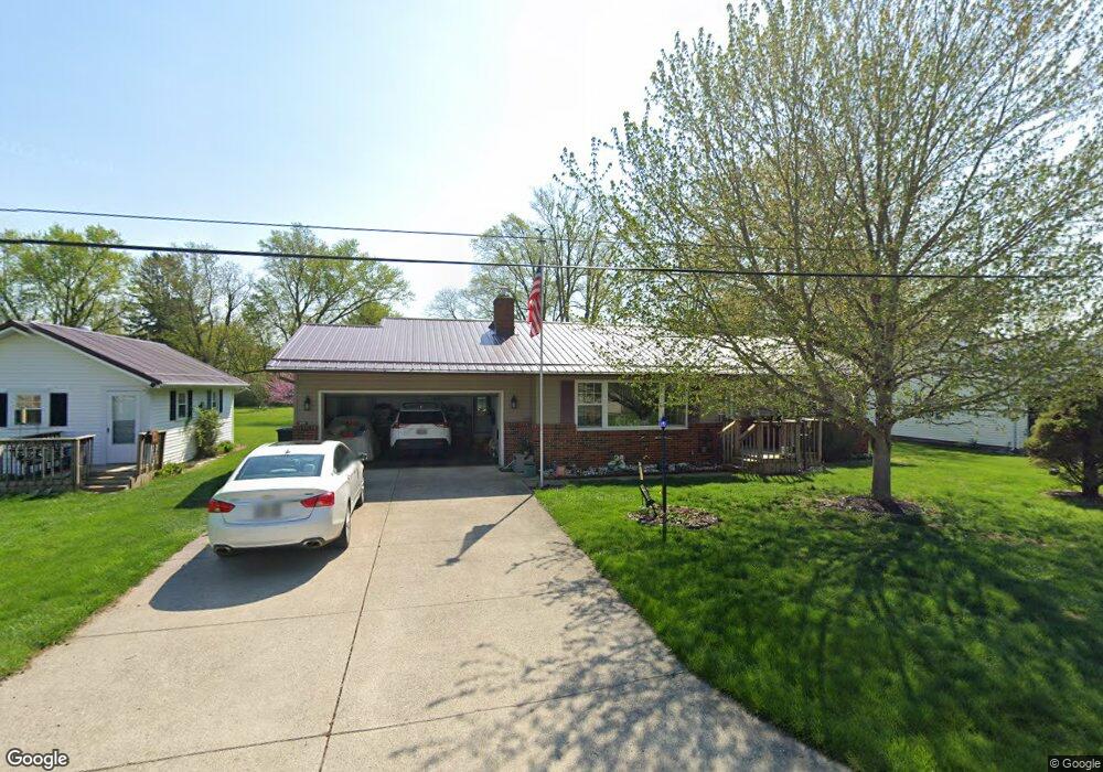
1830 Elmod Ave Newark, OH 43055
Estimated Value: $237,000 - $280,000
2
Beds
1
Bath
1,367
Sq Ft
$187/Sq Ft
Est. Value
About This Home
This home is located at 1830 Elmod Ave, Newark, OH 43055 and is currently estimated at $256,256, approximately $187 per square foot. 1830 Elmod Ave is a home located in Licking County with nearby schools including Legend Elementary School, Liberty Middle School, and Newark High School.
Ownership History
Date
Name
Owned For
Owner Type
Purchase Details
Closed on
Dec 14, 2011
Sold by
St John Faye
Bought by
St John Faye and St John Carroll
Current Estimated Value
Purchase Details
Closed on
Nov 22, 2011
Sold by
Lahmon Ralph and Lahmon Linda L
Bought by
St John Faye
Purchase Details
Closed on
Jul 14, 2011
Sold by
Estate Of Vera P Albery
Bought by
Lahmon Robert and Lahmon Ralph
Create a Home Valuation Report for This Property
The Home Valuation Report is an in-depth analysis detailing your home's value as well as a comparison with similar homes in the area
Home Values in the Area
Average Home Value in this Area
Purchase History
| Date | Buyer | Sale Price | Title Company |
|---|---|---|---|
| St John Faye | -- | Attorney | |
| St John Faye | $30,000 | Attorney | |
| St John Faye | $300,000 | Attorney | |
| Lahmon Robert | -- | None Available |
Source: Public Records
Tax History
| Year | Tax Paid | Tax Assessment Tax Assessment Total Assessment is a certain percentage of the fair market value that is determined by local assessors to be the total taxable value of land and additions on the property. | Land | Improvement |
|---|---|---|---|---|
| 2024 | $1,907 | $56,700 | $9,380 | $47,320 |
| 2023 | $1,930 | $56,700 | $9,380 | $47,320 |
| 2022 | $1,999 | $51,940 | $5,880 | $46,060 |
| 2021 | $2,084 | $51,940 | $5,880 | $46,060 |
| 2020 | $2,026 | $51,940 | $5,880 | $46,060 |
| 2019 | $1,554 | $40,110 | $4,690 | $35,420 |
| 2018 | $1,555 | $0 | $0 | $0 |
| 2017 | $1,489 | $0 | $0 | $0 |
| 2016 | $1,205 | $0 | $0 | $0 |
| 2015 | $614 | $0 | $0 | $0 |
| 2014 | $825 | $0 | $0 | $0 |
| 2013 | $1,610 | $0 | $0 | $0 |
Source: Public Records
Map
Nearby Homes
- 130 Gregory Dr
- 1821 Mount Vernon Rd
- 98 Glenridge Dr
- 1984 Jamesburg St
- 1954 Iselin St
- 1980 Jamesburg St
- 1964 Jamesburg St
- 1972 Jamesburg St
- 1956 Jamesburg St
- Mt Vernon Rd Unit LotWP001
- 359 Quail Run Ct
- 1521 W Quail Run Dr
- 1501 Pheasant Run Dr
- 41 Oregon Ave
- 1381 Hillview Cir W Unit 1381
- 1324 Hillview Cir W
- 1206 Hillview Cir E Unit 1206
- 2412 E Audrey Dr
- 324 Kells Ct W
- 681 Woods Edge Ln
- 1828 Elmod Ave
- 1831 Elmod Ave
- 1824 Elmod Ave
- 1827 Elmod Ave
- 65 N Vernon Ave
- 105 N Vernon Ave
- 1820 Elmod Ave
- 1823 Elmod Ave
- 113 N Vernon Ave
- 1819 Elmod Ave
- 88 N Vernon Ave
- 82 N Vernon Ave
- 98 N Vernon Ave
- 76 N Vernon Ave
- 129 N Vernon Ave
- 112 Gregory Dr
- 122 Gregory Dr
- 106 N Vernon Ave
- 104 Gregory Dr
- 49 N Vernon Ave
Your Personal Tour Guide
Ask me questions while you tour the home.