Estimated Value: $136,405 - $407,000
3
Beds
1
Bath
1,199
Sq Ft
$219/Sq Ft
Est. Value
About This Home
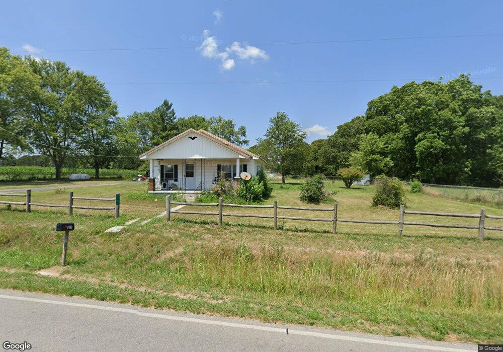
This home is located at 1831 State Highway D, Crane, MO 65633 and is currently estimated at $262,802, approximately $219 per square foot. 1831 State Highway D is a home located in Stone County with nearby schools including Crane Elementary School and Crane High School.
Ownership History
Date
Name
Owned For
Owner Type
Purchase Details
Closed on
May 20, 2022
Sold by
Douglas Young Clint
Bought by
Bo Chastain Properties Vii Llc
Current Estimated Value
Purchase Details
Closed on
Jan 28, 2022
Sold by
Johnson and Virginia
Bought by
Young Clint Douglas
Home Financials for this Owner
Home Financials are based on the most recent Mortgage that was taken out on this home.
Original Mortgage
$96,000
Interest Rate
3.22%
Mortgage Type
New Conventional
Purchase Details
Closed on
Apr 16, 2009
Sold by
Seaton Louise
Bought by
Johnson Edward and Johnson Virginia
Home Financials for this Owner
Home Financials are based on the most recent Mortgage that was taken out on this home.
Original Mortgage
$111,184
Interest Rate
5.24%
Mortgage Type
Future Advance Clause Open End Mortgage
Create a Home Valuation Report for This Property
The Home Valuation Report is an in-depth analysis detailing your home's value as well as a comparison with similar homes in the area
Purchase History
| Date | Buyer | Sale Price | Title Company |
|---|---|---|---|
| Bo Chastain Properties Vii Llc | -- | None Listed On Document | |
| Young Clint Douglas | -- | None Listed On Document | |
| Johnson Edward | -- | -- |
Source: Public Records
Mortgage History
| Date | Status | Borrower | Loan Amount |
|---|---|---|---|
| Previous Owner | Young Clint Douglas | $96,000 | |
| Previous Owner | Johnson Edward | $111,184 |
Source: Public Records
Tax History
| Year | Tax Paid | Tax Assessment Tax Assessment Total Assessment is a certain percentage of the fair market value that is determined by local assessors to be the total taxable value of land and additions on the property. | Land | Improvement |
|---|---|---|---|---|
| 2025 | $292 | $5,780 | -- | -- |
| 2024 | $291 | $5,780 | -- | -- |
| 2023 | $291 | $5,780 | $0 | $0 |
| 2022 | $290 | $5,780 | $0 | $0 |
| 2021 | $293 | $5,780 | $0 | $0 |
| 2020 | $291 | $5,780 | $0 | $0 |
| 2019 | $290 | $5,780 | $0 | $0 |
| 2018 | $291 | $5,780 | $0 | $0 |
| 2017 | $291 | $5,800 | $0 | $0 |
| 2016 | $285 | $5,800 | $0 | $0 |
| 2015 | $284 | $5,800 | $0 | $0 |
| 2014 | $279 | $5,650 | $0 | $0 |
| 2012 | $257 | $5,650 | $0 | $0 |
Source: Public Records
Map
Nearby Homes
- 406 Kadee Dr
- 4220 State Highway D
- 202 N Hemphill Ave
- 000 E Lockhart St
- 103 E Meadow Ave
- Tbd Missouri 413
- 000 Pine St
- 000 College St
- 311 College St
- 502 Myrtle St
- 206 Christiana St
- 208 E Maud Ave
- 107 E Mockingbird Ln
- 42 Pacific Dr
- 1601 State Highway B
- 1774 248-30
- 519 State Highway Jj
- 000 Track 3 State Hwy Jj
- 000 Track 2 State Hwy Jj
- 23211 Farm Road 2050
- 1831 State Highway D
- 1831 State Highway D
- 1557 State Highway D
- 1356 Miners Trail
- 819 Musky Dime Dr
- 1307 Miners Trail
- 1200 Miners Trail
- 1174 Miners Trail
- 862 Miners Trail
- 1321 Miners Trail
- 1397 Musky Dime Dr
- 1625 Musky Dime Dr
- 227 State Highway Tt
- 1625 D-10
- 1414 Musky Dime Dr
- 695 Miners Trail
- 1007 Musky Dime Dr
- 767 Miners Trail
- 1119 State Highway D
- 66 Spencers Mill Rd
Your Personal Tour Guide
Ask me questions while you tour the home.