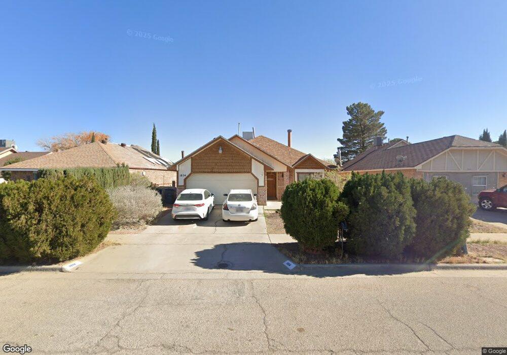
1834 Chris Scott Dr El Paso, TX 79936
O'Shea Keleher NeighborhoodEstimated Value: $210,679 - $245,000
3
Beds
2
Baths
1,516
Sq Ft
$151/Sq Ft
Est. Value
About This Home
This home is located at 1834 Chris Scott Dr, El Paso, TX 79936 and is currently estimated at $229,170, approximately $151 per square foot. 1834 Chris Scott Dr is a home located in El Paso County with nearby schools including O'shea Keleher Elementary School, William D Slider Middle School, and Montwood High School.
Ownership History
Date
Name
Owned For
Owner Type
Purchase Details
Closed on
Jul 7, 2023
Sold by
Nunez Manuela A
Bought by
Manuela A Nunez Irrecovable Trust
Current Estimated Value
Purchase Details
Closed on
Jul 28, 1997
Sold by
Hazen Robin and Hazen Eva
Bought by
Nunez Juan F and Nunez Manuela A
Home Financials for this Owner
Home Financials are based on the most recent Mortgage that was taken out on this home.
Original Mortgage
$56,000
Interest Rate
7.59%
Create a Home Valuation Report for This Property
The Home Valuation Report is an in-depth analysis detailing your home's value as well as a comparison with similar homes in the area
Home Values in the Area
Average Home Value in this Area
Purchase History
| Date | Buyer | Sale Price | Title Company |
|---|---|---|---|
| Manuela A Nunez Irrecovable Trust | -- | None Listed On Document | |
| Nunez Juan F | -- | -- |
Source: Public Records
Mortgage History
| Date | Status | Borrower | Loan Amount |
|---|---|---|---|
| Previous Owner | Nunez Juan F | $56,000 |
Source: Public Records
Tax History Compared to Growth
Tax History
| Year | Tax Paid | Tax Assessment Tax Assessment Total Assessment is a certain percentage of the fair market value that is determined by local assessors to be the total taxable value of land and additions on the property. | Land | Improvement |
|---|---|---|---|---|
| 2025 | $5,216 | $202,645 | $20,443 | $182,202 |
| 2024 | $5,216 | $202,645 | $20,443 | $182,202 |
| 2023 | $5,275 | $183,232 | $20,443 | $162,789 |
| 2022 | $4,788 | $165,331 | $20,443 | $144,888 |
| 2021 | $4,493 | $142,754 | $20,443 | $122,311 |
| 2020 | $3,806 | $119,919 | $16,506 | $103,413 |
| 2018 | $3,512 | $120,105 | $16,506 | $103,599 |
| 2017 | $3,284 | $114,960 | $16,506 | $98,454 |
| 2016 | $3,194 | $111,818 | $16,506 | $95,312 |
| 2015 | $3,084 | $111,818 | $16,506 | $95,312 |
| 2014 | $3,084 | $111,109 | $16,506 | $94,603 |
Source: Public Records
Map
Nearby Homes
- 11663 Clear Lake Way
- 1935 Bay City Place
- 11539 Clear Lake Way
- 2029 Greenlee Dr
- 1733 Karl Wyler Dr
- 2078 Gus Moran St
- TBD 001 Montwood Dr
- TBD 006 Montwood Dr
- TBD 003 Montwood Dr
- TBD 004 Montwood Dr
- TBD 005 Montwood Dr
- TBD 002 Montwood Dr
- 1904 Ralph Janes Place
- 11654 Bob Mitchell Dr
- 1690 Leroy Bonse Dr
- 11709 Ronald McNair Dr
- 11648 Lake Erie Dr
- 3655 George Dieter Dr
- 2258 Bill Horn Way
- 11506 James Grant Dr
- 1832 Chris Scott Dr
- 1830 Chris Scott Dr
- 1838 Chris Scott Dr
- 1971 Dana Bree Dr
- 1969 Dana Bree Dr
- 1973 Dana Bree Dr
- 1967 Dana Bree Dr
- 1975 Dana Bree Dr
- 1900 Chris Scott Dr
- 1835 Chris Scott Dr
- 1833 Chris Scott Dr
- 1837 Chris Scott Dr
- 1965 Dana Bree Dr
- 1977 Dana Bree Dr
- 1831 Chris Scott Dr El Paso T Dr
- 1831 Chris Scott Dr
- 1902 Chris Scott Dr
- 1826 Chris Scott Dr
- 1829 Chris Scott Dr
- 1979 Dana Bree Dr