


1836 SE Locust Ave Portland, OR 97214
Hosford-Abernethy NeighborhoodEstimated payment $7,230/month
Highlights
- Popular Property
- View of Trees or Woods
- Wood Flooring
- Abernethy Elementary School Rated 10
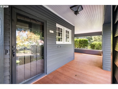
- Craftsman Architecture
- 4-minute walk to Ladd Circle Park
About This Home
OPEN HOUSE SATURDAY 11-1 & SUNDAY 2-4! Located in historic Ladd’s Addition, this distinguished 1908 residence embodies the timeless character of a Craftsman-influenced Portland Foursquare. Its front-gable roofline, wide overhanging eaves, and broad covered porch reflect early-Portland craftsmanship, complemented by original millwork and multi-pane windows highlighting its graceful façade. Set on a distinctive unique lot with rare, wide frontage for the neighborhood, the property offers a sense of privacy, lush mature landscaping, and the beauty of a designated Portland Heritage Tree #287. A spacious, detached three-car garage offers room for vehicles, storage, and versatile use. Inside, beautifully maintained period features include rich woodwork, leaded glass, original hardwood floors, beamed ceilings, and classic built-ins. Bright, spacious rooms flow effortlessly from the welcoming entry through the living and dining areas, with large picture windows framing tree-lined street views. The upper level features four comfortably sized bedrooms, a full bath, and a sunroom ideal for reading, office use, or creative pursuits. The expansive finished lower level adds even more versatility with generous bonus/living space, a full bathroom, and direct exterior access. With its quiet, friendly, village-like atmosphere and proximity to neighborhood markets, local eateries and more, Ladd’s Addition offers an unmatched blend of history, charm, and convenience. A truly inviting place to live. [Home Energy Score = 1. HES Report at
Listing Agent
Keller Williams Realty Professionals License #200906047 Listed on: 12/10/2025

Open House Schedule
-
Saturday, December 13, 202511:00 am to 1:00 pm12/13/2025 11:00:00 AM +00:0012/13/2025 1:00:00 PM +00:00Add to Calendar
-
Sunday, December 14, 20252:00 to 4:00 pm12/14/2025 2:00:00 PM +00:0012/14/2025 4:00:00 PM +00:00Add to Calendar
Home Details
Home Type
- Single Family
Est. Annual Taxes
- $11,018
Year Built
- Built in 1908
Lot Details
- 8,276 Sq Ft Lot
- Corner Lot
- Landscaped with Trees
- Private Yard
- Property is zoned R5
Parking
- 3 Car Detached Garage
- Extra Deep Garage
- Garage Door Opener
- Off-Street Parking
Home Design
- Craftsman Architecture
- American Four Square Architecture
- Composition Roof
- Concrete Perimeter Foundation
Interior Spaces
- 3,824 Sq Ft Home
- 3-Story Property
- Wainscoting
- Ceiling Fan
- 2 Fireplaces
- Wood Burning Fireplace
- Electric Fireplace
- Wood Frame Window
- Family Room
- Living Room
- Dining Room
- Bonus Room
- Views of Woods
- Security System Owned
- Laundry Room
- Finished Basement
Kitchen
- Free-Standing Range
- Range Hood
- Dishwasher
- Stainless Steel Appliances
- Tile Countertops
- Disposal
Flooring
- Wood
- Tile
Bedrooms and Bathrooms
- 4 Bedrooms
Eco-Friendly Details
- Green Certified Home
Outdoor Features
- Sun Deck
- Covered Patio or Porch
Schools
- Abernethy Elementary School
- Hosford Middle School
- Cleveland High School
Utilities
- Forced Air Heating and Cooling System
- Heating System Uses Gas
- Electric Water Heater
Community Details
- No Home Owners Association
- Ladds Addition Subdivision
Listing and Financial Details
- Assessor Parcel Number R200556
Map
Home Values in the Area
Average Home Value in this Area
Tax History
| Year | Tax Paid | Tax Assessment Tax Assessment Total Assessment is a certain percentage of the fair market value that is determined by local assessors to be the total taxable value of land and additions on the property. | Land | Improvement |
|---|---|---|---|---|
| 2025 | $11,018 | $408,910 | -- | -- |
| 2024 | $10,622 | $397,000 | -- | -- |
| 2023 | $10,214 | $385,440 | $0 | $0 |
| 2022 | $9,993 | $374,220 | $0 | $0 |
| 2021 | $9,824 | $363,330 | $0 | $0 |
| 2020 | $9,012 | $352,750 | $0 | $0 |
| 2019 | $8,680 | $342,480 | $0 | $0 |
| 2018 | $8,425 | $332,510 | $0 | $0 |
| 2017 | $8,075 | $322,830 | $0 | $0 |
| 2016 | $7,390 | $313,430 | $0 | $0 |
| 2015 | $7,196 | $304,310 | $0 | $0 |
| 2014 | $7,087 | $295,450 | $0 | $0 |
Property History
| Date | Event | Price | List to Sale | Price per Sq Ft |
|---|---|---|---|---|
| 12/10/2025 12/10/25 | For Sale | $1,200,000 | -- | $314 / Sq Ft |
Purchase History
| Date | Type | Sale Price | Title Company |
|---|---|---|---|
| Special Warranty Deed | -- | None Listed On Document | |
| Special Warranty Deed | -- | None Listed On Document | |
| Personal Reps Deed | $86,000 | None Listed On Document | |
| Interfamily Deed Transfer | -- | None Available |
Source: Regional Multiple Listing Service (RMLS)
MLS Number: 522169437
APN: R200556
Disclaimer: Certain information contained herein is derived from information provided by parties other than Homes.com. All information provided is deemed reliable, but is not guaranteed to be accurate and should be independently verified.
![]() The content relating to real estate for sale on this web site comes in part from the IDX program of the RMLS™ of Portland, Oregon. Real estate listings held by brokerage firms other than Ten-X are marked with the RMLS™ logo, and detailed information about these properties includes the names of the listing brokers. Listing content is copyright © 2025 RMLS™, Portland, Oregon. Some properties which appear for sale on this web site may subsequently have sold or may no longer be available. All information provided is deemed reliable but is not guaranteed and should be independently verified.
The content relating to real estate for sale on this web site comes in part from the IDX program of the RMLS™ of Portland, Oregon. Real estate listings held by brokerage firms other than Ten-X are marked with the RMLS™ logo, and detailed information about these properties includes the names of the listing brokers. Listing content is copyright © 2025 RMLS™, Portland, Oregon. Some properties which appear for sale on this web site may subsequently have sold or may no longer be available. All information provided is deemed reliable but is not guaranteed and should be independently verified.
- 2033 SE 22nd Ave
- 1408 SE 22nd Ave
- 1805 SE Madison St Unit 304
- 2212 SE Tamarack Ave
- 1990 SE Mulberry Ave
- 2025 SE Caruthers St Unit 24
- 2025 SE Caruthers St Unit 14
- 2301 SE Caruthers St Unit 10
- 1312 SE Hawthorne Blvd
- 1844 SE 12th Ave
- 2264 SE Division St
- 2268 SE Division St
- 1116 SE Stephens St
- 2451 SE Salmon St
- 2013 SE Yamhill St
- 2135 SE 12th Ave
- 928 SE 18th Ave
- 2805 SE Grant St
- 2406 SE Yamhill St
- 2303 SE 12th Ave
- 1550 SE 20th Ave
- 1428 SE 19th Ave Unit ID1309871P
- 2390 SE Hawthorne Blvd
- 2124 SE Elliott Ave Unit 1
- 2322 SE Main St Unit SE Hawthorne Upper Apt
- 2605 SE 23rd Ave Unit B
- 1509 SE Belmont St
- 917 SE 25th Ave Unit ID1309860P
- 1032-1036-1036 Se 12th Ave Unit ID1309849P
- 2725-2743-2743 Se Taylor St Unit 2727
- 2725-2743-2743 Se Taylor St Unit 2737
- 909 SE 12th Ave
- 2715 SE 28th Ave
- 975 SE 11th Ave
- 2919 SE Division St Unit 403
- 2919 SE Division St
- 2334 SE 8th Ave Unit ID1309820P
- 915 SE 29th Ave Unit ID1309869P
- 1205 SE Morrison St
- 2175 SE Stark St