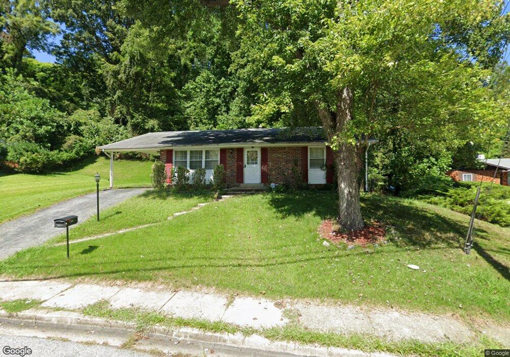
1836 Taylor Ave Fort Washington, MD 20744
Estimated Value: $318,000 - $407,000
--
Bed
2
Baths
1,287
Sq Ft
$293/Sq Ft
Est. Value
About This Home
This home is located at 1836 Taylor Ave, Fort Washington, MD 20744 and is currently estimated at $377,330, approximately $293 per square foot. 1836 Taylor Ave is a home located in Prince George's County with nearby schools including Fort Washington Forest Elementary School, Accokeek Academy, and Friendly High School.
Ownership History
Date
Name
Owned For
Owner Type
Purchase Details
Closed on
Jun 14, 2007
Sold by
Bast Elizabeth A
Bought by
Davis Hansel C Etal
Current Estimated Value
Home Financials for this Owner
Home Financials are based on the most recent Mortgage that was taken out on this home.
Original Mortgage
$330,000
Outstanding Balance
$200,948
Interest Rate
6.19%
Mortgage Type
Purchase Money Mortgage
Estimated Equity
$176,382
Purchase Details
Closed on
May 29, 2007
Sold by
Bast Elizabeth A
Bought by
Davis Hansel C Etal
Home Financials for this Owner
Home Financials are based on the most recent Mortgage that was taken out on this home.
Original Mortgage
$330,000
Outstanding Balance
$200,948
Interest Rate
6.19%
Mortgage Type
Purchase Money Mortgage
Estimated Equity
$176,382
Purchase Details
Closed on
May 6, 1977
Sold by
Bast Richard J
Bought by
Bast Elizabeth A
Create a Home Valuation Report for This Property
The Home Valuation Report is an in-depth analysis detailing your home's value as well as a comparison with similar homes in the area
Home Values in the Area
Average Home Value in this Area
Purchase History
| Date | Buyer | Sale Price | Title Company |
|---|---|---|---|
| Davis Hansel C Etal | $330,000 | -- | |
| Davis Hansel C Etal | $330,000 | -- | |
| Bast Elizabeth A | $12,000 | -- |
Source: Public Records
Mortgage History
| Date | Status | Borrower | Loan Amount |
|---|---|---|---|
| Open | Davis Hansel C Etal | $330,000 | |
| Closed | Davis Hansel C Etal | $330,000 |
Source: Public Records
Tax History Compared to Growth
Tax History
| Year | Tax Paid | Tax Assessment Tax Assessment Total Assessment is a certain percentage of the fair market value that is determined by local assessors to be the total taxable value of land and additions on the property. | Land | Improvement |
|---|---|---|---|---|
| 2025 | $5,001 | $323,667 | -- | -- |
| 2024 | $5,001 | $309,700 | $104,200 | $205,500 |
| 2023 | $4,704 | $289,767 | $0 | $0 |
| 2022 | $4,408 | $269,833 | $0 | $0 |
| 2021 | $4,111 | $249,900 | $102,100 | $147,800 |
| 2020 | $4,034 | $244,667 | $0 | $0 |
| 2019 | $3,956 | $239,433 | $0 | $0 |
| 2018 | $3,878 | $234,200 | $77,100 | $157,100 |
| 2017 | $3,639 | $218,133 | $0 | $0 |
| 2016 | -- | $202,067 | $0 | $0 |
| 2015 | $2,841 | $186,000 | $0 | $0 |
| 2014 | $2,841 | $182,100 | $0 | $0 |
Source: Public Records
Map
Nearby Homes
- 1916 Taylor Ave
- 13318 Chalfont Ave
- 1410 Fillmore Rd
- 13503 Harrison Ave
- 12904 Chalfont Ave
- 12806 Monroe Ave
- 14005 Livingston Rd
- 0 Joseph Dr
- 2421 Baileys Pond Rd
- 13102 Gerry Rd
- 2608 Saint Marys View Rd
- 804 Cascade Dr
- 802 Cornish St
- 2001 Medinah Ridge Rd
- 13303 Pendleton St
- 13403 Pendleton St
- 2201 Herring Creek Dr
- 12309 Livingston Rd
- 14311 Livingston Rd
- 12204 Clear Creek Dr
- 1900 Taylor Ave
- 1834 Taylor Ave
- 1832 Taylor Ave
- 1833 Taylor Ave
- 1902 Taylor Ave
- 1710 Tioga Rd
- 1829 Taylor Ave
- 1830 Taylor Ave
- 1905 Taylor Ave
- 1904 Taylor Ave
- 1708 Tioga Rd
- 1828 Taylor Ave
- 1827 Taylor Ave
- 1909 Taylor Ave
- 1906 Taylor Ave
- 1706 Tioga Rd
- 1711 Tioga Rd
- 13111 Chalfont Ave
- 13203 Chalfont Ave
- 1826 Taylor Ave