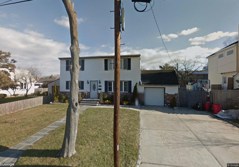
1839 Atlantic Ave North Bellmore, NY 11710
Estimated Value: $737,000 - $837,594
--
Bed
2
Baths
1,886
Sq Ft
$417/Sq Ft
Est. Value
About This Home
This home is located at 1839 Atlantic Ave, North Bellmore, NY 11710 and is currently estimated at $787,297, approximately $417 per square foot. 1839 Atlantic Ave is a home located in Nassau County with nearby schools including Weatherford West Elementary School, Lt. General Thomas P. Stafford Elementary School, and Grand Avenue Middle School.
Ownership History
Date
Name
Owned For
Owner Type
Purchase Details
Closed on
Sep 15, 2008
Sold by
Us Bank National Assn
Bought by
Aurora Loan Services Llc
Current Estimated Value
Purchase Details
Closed on
Jan 22, 2008
Sold by
Naranjo Carolyn R
Purchase Details
Closed on
May 24, 2006
Sold by
Pascarelli Rose
Bought by
Arrigo Jeffrey
Purchase Details
Closed on
Sep 5, 2005
Sold by
Aurora Loan Services Llc
Bought by
Albala Daniel
Purchase Details
Closed on
Apr 16, 1998
Purchase Details
Closed on
Apr 22, 1997
Purchase Details
Closed on
Aug 31, 1996
Sold by
Pascarelli Roseann
Bought by
Fagen Anna
Create a Home Valuation Report for This Property
The Home Valuation Report is an in-depth analysis detailing your home's value as well as a comparison with similar homes in the area
Home Values in the Area
Average Home Value in this Area
Purchase History
| Date | Buyer | Sale Price | Title Company |
|---|---|---|---|
| Aurora Loan Services Llc | -- | Commonwealth Land Title | |
| -- | $440,424 | -- | |
| Arrigo Jeffrey | $504,000 | -- | |
| Albala Daniel | $322,646 | None Available | |
| -- | -- | -- | |
| -- | -- | -- | |
| Fagen Anna | -- | -- |
Source: Public Records
Tax History Compared to Growth
Tax History
| Year | Tax Paid | Tax Assessment Tax Assessment Total Assessment is a certain percentage of the fair market value that is determined by local assessors to be the total taxable value of land and additions on the property. | Land | Improvement |
|---|---|---|---|---|
| 2025 | $13,887 | $523 | $193 | $330 |
| 2024 | $3,579 | $518 | $191 | $327 |
| 2023 | $11,645 | $546 | $237 | $309 |
| 2022 | $11,645 | $544 | $201 | $343 |
| 2021 | $14,323 | $537 | $198 | $339 |
| 2020 | $9,713 | $507 | $430 | $77 |
| 2019 | $7,854 | $544 | $432 | $112 |
| 2018 | $7,946 | $580 | $0 | $0 |
| 2017 | $5,334 | $616 | $435 | $181 |
| 2016 | $8,082 | $653 | $415 | $238 |
| 2015 | $2,849 | $689 | $438 | $251 |
| 2014 | $2,849 | $689 | $438 | $251 |
| 2013 | $2,812 | $725 | $461 | $264 |
Source: Public Records
Map
Nearby Homes
- 2800 Pacific St
- 1914 Bergen St
- 2730 Court St
- 2730 Orchard St
- 2595 Castle Ct
- 2780 Natta Blvd
- 1787 Madison Ave
- 1529 Fenimore St
- 2693 Martin Ave
- 1541 Bellmore Rd
- 1680 Cornelius Ave
- 2672 Martin Ave
- 13 Metropolitan Ave
- 1483 Crown St
- 15 Jefferson Ave
- 1708 Cornelius Ave
- 1827 Jefferson Ave
- 1497 Carroll St
- 3019 Post Ave
- 2889 Anderson St
- 1847 Atlantic Ave
- 1847 Atlantic Ave
- 1831 Atlantic Ave
- 1840 White St
- 1846 White St
- 1834 White St
- 2801 Pacific St
- 1830 White St
- 1846 Atlantic Ave
- 1840 Atlantic Ave
- 2819 Pacific St
- 2806 Court St
- 2800 Court St
- 1856 Atlantic Ave
- 1826 White St
- 2794 Court St
- 102 Pacific St
- 2810 Court St
- 1841 White St
- 1864 White St