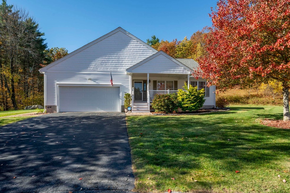
184 Apple Brook Way Unit 10 Manchester, NH 03109
Lower South Willow NeighborhoodEstimated payment $3,955/month
Highlights
- Wooded Lot
- Wood Flooring
- Family Room Off Kitchen
- Cathedral Ceiling
- 2 Car Direct Access Garage
- Walk-In Closet
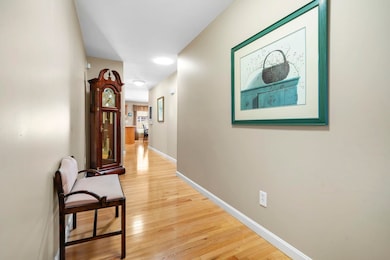
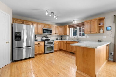
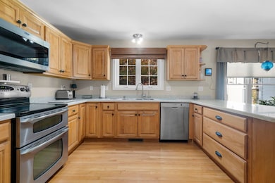
About This Home
Impeccably Maintained Home in a Desirable Cul-de-Sac Location
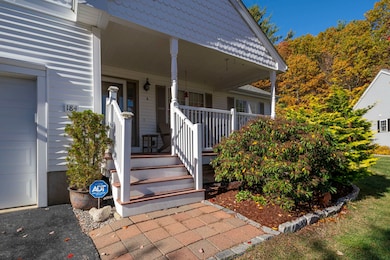
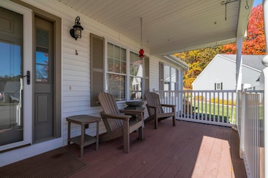
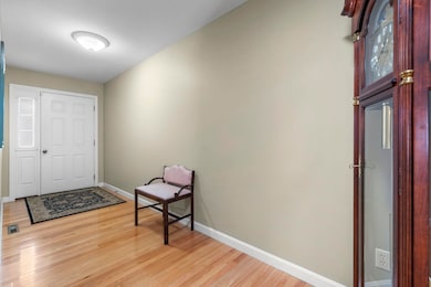
This beautifully cared for home reflects true pride of ownership inside and out. Nestled in a quiet cul-de-sac, it offers the perfect blend of comfort, quality and convenience. The open-concept floor plan provides effortless flow between the kitchen, dining and living areas - ideal for entertaining or relaxed everyday living. Enjoy the ease of first floor living with three bedrooms, abundant natural light and gleaming finishes throughout. The attached two-car garage and meticulously maintained landscaping enhance the property’s curb appeal and functionality. Set in a peaceful neighborhood close to shopping, dining, and major routes, this home is move-in ready and stands out for its exceptional care and condition.
Property Details
Home Type
- Condominium
Est. Annual Taxes
- $7,301
Year Built
- Built in 2006
Lot Details
- Landscaped
- Wooded Lot
- Garden
Parking
- 2 Car Direct Access Garage
- Automatic Garage Door Opener
- Driveway
Home Design
- Concrete Foundation
- Wood Frame Construction
- Vinyl Siding
Interior Spaces
- Property has 1 Level
- Central Vacuum
- Cathedral Ceiling
- Ceiling Fan
- Blinds
- Drapes & Rods
- Entrance Foyer
- Family Room Off Kitchen
- Living Room
- Combination Kitchen and Dining Room
Kitchen
- Microwave
- Dishwasher
Flooring
- Wood
- Carpet
- Tile
Bedrooms and Bathrooms
- 3 Bedrooms
- En-Suite Bathroom
- Walk-In Closet
- 2 Full Bathrooms
Laundry
- Laundry on main level
- Dryer
- Washer
Basement
- Basement Fills Entire Space Under The House
- Interior Basement Entry
Home Security
- Home Security System
- Smart Thermostat
Accessible Home Design
- Accessible Full Bathroom
- Accessible Washer and Dryer
- Hard or Low Nap Flooring
- Low Pile Carpeting
Outdoor Features
- Patio
Schools
- Green Acres Elementary School
- Mclaughlin Middle School
- Manchester Memorial High Sch
Utilities
- Forced Air Heating and Cooling System
- Cable TV Available
Listing and Financial Details
- Legal Lot and Block / / 0052
- Assessor Parcel Number 0808
Community Details
Overview
- South Ridge At Manchester Condominium Subdivision
Recreation
- Snow Removal
Security
- Security Service
- Fire and Smoke Detector
Map
Home Values in the Area
Average Home Value in this Area
Tax History
| Year | Tax Paid | Tax Assessment Tax Assessment Total Assessment is a certain percentage of the fair market value that is determined by local assessors to be the total taxable value of land and additions on the property. | Land | Improvement |
|---|---|---|---|---|
| 2024 | $7,301 | $372,900 | $0 | $372,900 |
| 2023 | $7,033 | $372,900 | $0 | $372,900 |
| 2022 | $6,802 | $372,900 | $0 | $372,900 |
| 2021 | $6,593 | $372,900 | $0 | $372,900 |
| 2020 | $6,722 | $272,600 | $0 | $272,600 |
| 2019 | $6,630 | $272,600 | $0 | $272,600 |
| 2018 | $6,455 | $272,600 | $0 | $272,600 |
| 2017 | $6,357 | $272,600 | $0 | $272,600 |
| 2016 | $6,308 | $272,600 | $0 | $272,600 |
| 2015 | $6,108 | $260,600 | $0 | $260,600 |
| 2014 | $6,893 | $293,300 | $0 | $293,300 |
| 2013 | $6,649 | $293,300 | $0 | $293,300 |
Property History
| Date | Event | Price | List to Sale | Price per Sq Ft |
|---|---|---|---|---|
| 10/23/2025 10/23/25 | For Sale | $635,000 | -- | $349 / Sq Ft |
Purchase History
| Date | Type | Sale Price | Title Company |
|---|---|---|---|
| Warranty Deed | -- | -- | |
| Warranty Deed | $296,500 | -- |
Mortgage History
| Date | Status | Loan Amount | Loan Type |
|---|---|---|---|
| Previous Owner | $180,600 | Unknown | |
| Previous Owner | $237,200 | No Value Available |
Source: PrimeMLS
MLS Number: 5067059
APN: MNCH-000808-000000-000052
Disclaimer: Certain information contained herein is derived from information provided by parties other than Homes.com. All information provided is deemed reliable, but is not guaranteed to be accurate and should be independently verified.
![]() Copyright 2025 PrimeMLS, Inc. All rights reserved. This information is deemed reliable, but not guaranteed. The data relating to real estate displayed on this display comes in part from the IDX Program of PrimeMLS. The information being provided is for consumers’ personal, non-commercial use and may not be used for any purpose other than to identify prospective properties consumers may be interested in purchasing.
Copyright 2025 PrimeMLS, Inc. All rights reserved. This information is deemed reliable, but not guaranteed. The data relating to real estate displayed on this display comes in part from the IDX Program of PrimeMLS. The information being provided is for consumers’ personal, non-commercial use and may not be used for any purpose other than to identify prospective properties consumers may be interested in purchasing.
- 30 Bryant Rd
- 90 Forest Hill Way Unit 52
- 24 Cranberry Way Unit 8
- 195 Corning Rd
- 133 Corning Rd
- 1901 Bodwell Rd Unit 28
- 759 Cohas Ave
- 193 Morning Glory Dr
- 1029 S Mammoth Rd Unit 28
- 1025 S Mammoth Rd Unit 8
- 1035 S Mammoth Rd Unit 6
- 81 Marathon Way Unit 6
- 45 Crescent Ln
- 3036 Bodwell Rd
- 612 Megan Dr
- 10100 S Willow St Unit 214
- 10100 S Willow St Unit 101
- 10100 S Willow St Unit 109
- 10100 S Willow St Unit 110
- 10100 S Willow St Unit 303
- 131 Forest Hill Way Unit 40
- 1445 Bodwell Rd
- 1225 Bodwell Rd Unit 30
- 1124 S Mammoth Rd
- 10100 S Willow St Unit 312
- 800 Harvey Rd
- 80 Greenwood Ct Unit 80 Greenwood Apartment
- 383 Huse Rd Unit 6
- 78 Manor Dr
- 2 Crestview Cir Unit 96
- 4 Crestview Cir Unit 101
- 0 Hartshorn Way
- 978 Cilley Rd Unit Cilley Rd - 2nd Floor
- 20 Sentinel Ct Unit 307
- 20 Sentinel Ct Unit 104
- 81 Maurice St
- 50 Sentinel Ct Unit L06
- 60 Kilby St Unit 2
- 45 Nectaria Way
- 90 Longwood Ave Unit 1
