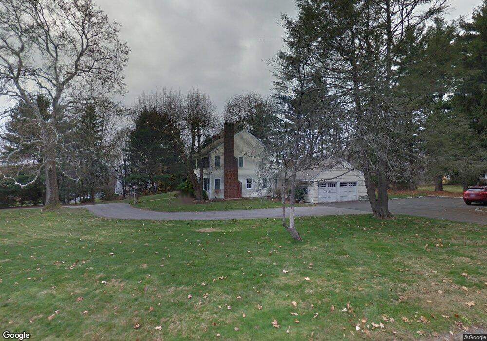
184 Brushy Ridge Rd New Canaan, CT 06840
Estimated Value: $1,938,468 - $2,638,000
4
Beds
3
Baths
3,456
Sq Ft
$629/Sq Ft
Est. Value
About This Home
This home is located at 184 Brushy Ridge Rd, New Canaan, CT 06840 and is currently estimated at $2,174,117, approximately $629 per square foot. 184 Brushy Ridge Rd is a home located in Fairfield County with nearby schools including East Elementary School, Saxe Middle School, and New Canaan High School.
Ownership History
Date
Name
Owned For
Owner Type
Purchase Details
Closed on
Mar 10, 1999
Sold by
Callahan Timothy M and Callahan Deborah W
Bought by
Ahrens Paul C and Ahrens Jennifer G
Current Estimated Value
Purchase Details
Closed on
Jun 12, 1990
Sold by
Dunn Judy
Bought by
Callahan Timothy
Create a Home Valuation Report for This Property
The Home Valuation Report is an in-depth analysis detailing your home's value as well as a comparison with similar homes in the area
Home Values in the Area
Average Home Value in this Area
Purchase History
| Date | Buyer | Sale Price | Title Company |
|---|---|---|---|
| Ahrens Paul C | $871,500 | -- | |
| Callahan Timothy | $420,000 | -- |
Source: Public Records
Mortgage History
| Date | Status | Borrower | Loan Amount |
|---|---|---|---|
| Open | Callahan Timothy | $200,000 | |
| Open | Callahan Timothy | $601,000 |
Source: Public Records
Tax History Compared to Growth
Tax History
| Year | Tax Paid | Tax Assessment Tax Assessment Total Assessment is a certain percentage of the fair market value that is determined by local assessors to be the total taxable value of land and additions on the property. | Land | Improvement |
|---|---|---|---|---|
| 2025 | $16,972 | $1,016,890 | $630,000 | $386,890 |
| 2024 | $16,413 | $1,016,890 | $630,000 | $386,890 |
| 2023 | $15,426 | $814,450 | $605,570 | $208,880 |
| 2022 | $14,961 | $814,450 | $605,570 | $208,880 |
| 2021 | $14,790 | $814,450 | $605,570 | $208,880 |
| 2020 | $14,790 | $814,450 | $605,570 | $208,880 |
| 2019 | $14,856 | $814,450 | $605,570 | $208,880 |
| 2018 | $17,647 | $1,040,480 | $672,840 | $367,640 |
| 2017 | $17,345 | $1,040,480 | $672,840 | $367,640 |
| 2016 | $16,970 | $1,040,480 | $672,840 | $367,640 |
| 2015 | $16,637 | $1,040,480 | $672,840 | $367,640 |
| 2014 | $16,169 | $1,040,480 | $672,840 | $367,640 |
Source: Public Records
Map
Nearby Homes
- 262 Brushy Ridge Rd
- 145 River St
- 52 Garibaldi Ln
- 61 Smith Ridge Rd
- 101 Parade Hill Rd
- 240 Rosebrook Rd
- 204 Parade Hill Rd
- 42 Forest St Unit A
- 60 East Ave
- 64 East Ave
- 15 Burtis Ave Unit Townhome B
- 15 Burtis Ave Unit Townhome D
- 15 Burtis Ave Unit West Penthouse B
- 15 Burtis Ave Unit East Penthouse C
- 15 Burtis Ave Unit Townhome A
- 15 Burtis Ave Unit East Plaza 203
- 67 Carter St
- 180 Summer St
- 48 Brookwood Ln
- 38 Fitch Ln
- 170 Brushy Ridge Rd
- 186 Brushy Ridge Rd
- 186 Brushy Ridge Rd
- 204 Brushy Ridge Rd
- 190 Brushy Ridge Rd
- 190 Brushy Ridge Rd
- 181 Brushy Ridge Rd
- 148 Brushy Ridge Rd
- 146 Brushy Ridge Rd
- 203 Brushy Ridge Rd
- 123 Garibaldi Ln
- 188 Brushy Ridge Rd
- 192 Brushy Ridge Rd
- 183 Brushy Ridge Rd
- 54 Rosebrook Rd
- 109 Garibaldi Ln
- 150 Brushy Ridge Rd
- 100 Garibaldi Ln
- 100 Garibaldi Ln Unit Lot 138
- 12 Rosebrook Rd