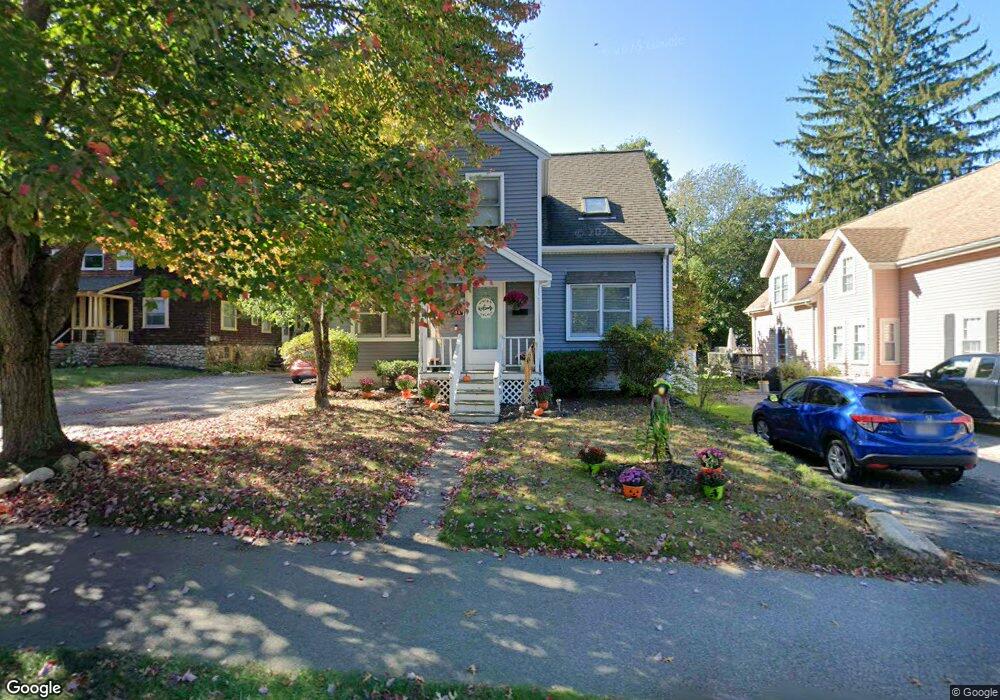
184 Exchange St Millis, MA 02054
Estimated Value: $574,000 - $623,000
4
Beds
2
Baths
1,579
Sq Ft
$382/Sq Ft
Est. Value
About This Home
This home is located at 184 Exchange St, Millis, MA 02054 and is currently estimated at $602,568, approximately $381 per square foot. 184 Exchange St is a home located in Norfolk County with nearby schools including Clyde F Brown, Millis Middle School, and Millis High School.
Ownership History
Date
Name
Owned For
Owner Type
Purchase Details
Closed on
Sep 27, 2007
Sold by
Deutsche Bank Natl T C
Bought by
Fournier Dawn M and Fournier Stephen
Current Estimated Value
Home Financials for this Owner
Home Financials are based on the most recent Mortgage that was taken out on this home.
Original Mortgage
$250,000
Outstanding Balance
$159,651
Interest Rate
6.65%
Mortgage Type
Purchase Money Mortgage
Estimated Equity
$442,917
Purchase Details
Closed on
Jun 28, 2007
Sold by
Strasnick Sheldon
Bought by
Deutsche Bank Natl T C
Purchase Details
Closed on
Aug 15, 2001
Sold by
Ohara Rebecca A
Bought by
Strasnick Sheldon and Strasnick Michelle
Home Financials for this Owner
Home Financials are based on the most recent Mortgage that was taken out on this home.
Original Mortgage
$191,900
Interest Rate
7.16%
Mortgage Type
Purchase Money Mortgage
Purchase Details
Closed on
Aug 30, 1991
Sold by
Ohara Louise T
Bought by
Ohara John H and Ohara Rebecce
Create a Home Valuation Report for This Property
The Home Valuation Report is an in-depth analysis detailing your home's value as well as a comparison with similar homes in the area
Home Values in the Area
Average Home Value in this Area
Purchase History
| Date | Buyer | Sale Price | Title Company |
|---|---|---|---|
| Fournier Dawn M | $250,000 | -- | |
| Deutsche Bank Natl T C | $246,018 | -- | |
| Strasnick Sheldon | $239,900 | -- | |
| Ohara John H | $19,000 | -- |
Source: Public Records
Mortgage History
| Date | Status | Borrower | Loan Amount |
|---|---|---|---|
| Open | Fournier Dawn M | $250,000 | |
| Previous Owner | Strasnick Sheldon | $191,900 | |
| Previous Owner | Ohara John H | $62,000 |
Source: Public Records
Tax History
| Year | Tax Paid | Tax Assessment Tax Assessment Total Assessment is a certain percentage of the fair market value that is determined by local assessors to be the total taxable value of land and additions on the property. | Land | Improvement |
|---|---|---|---|---|
| 2025 | $8,908 | $543,200 | $227,600 | $315,600 |
| 2024 | $8,190 | $498,800 | $210,100 | $288,700 |
| 2023 | $7,626 | $436,000 | $167,500 | $268,500 |
| 2022 | $7,731 | $409,500 | $179,700 | $229,800 |
| 2021 | $7,087 | $361,200 | $155,300 | $205,900 |
| 2020 | $7,295 | $362,200 | $145,200 | $217,000 |
| 2019 | $6,337 | $338,900 | $131,400 | $207,500 |
| 2018 | $6,107 | $338,900 | $131,400 | $207,500 |
| 2017 | $5,471 | $297,000 | $111,100 | $185,900 |
| 2016 | $5,358 | $307,200 | $111,100 | $196,100 |
| 2015 | $5,222 | $307,200 | $111,100 | $196,100 |
Source: Public Records
Map
Nearby Homes
- 192 Exchange St
- 183 Exchange St
- 180 Exchange St
- 180 Exchange St Unit 180
- 196 Exchange St
- 196 Exchange St Unit 1
- 193 Exchange St
- 175 Exchange St
- 172 Exchange St
- 205 Exchange St
- 23 Cedar Square
- 166 Exchange St
- 25 Cedar Square
- 163 Exchange St
- 20 Cedar Square
- 19 Cedar Square
- 18 Cedar Square
- 12 Clark Rd
- 103 Curve St
- 17 Cedar Square
Your Personal Tour Guide
Ask me questions while you tour the home.