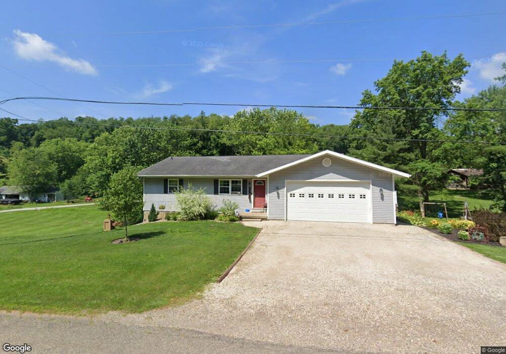
184 Fork Rd SE New Philadelphia, OH 44663
Estimated Value: $152,000
3
Beds
1
Bath
1,232
Sq Ft
$123/Sq Ft
Est. Value
About This Home
This home is located at 184 Fork Rd SE, New Philadelphia, OH 44663 and is currently estimated at $152,000, approximately $123 per square foot. 184 Fork Rd SE is a home located in Tuscarawas County with nearby schools including Midvale Elementary School, Tuscarawas Middle School, and Indian Valley High School.
Ownership History
Date
Name
Owned For
Owner Type
Purchase Details
Closed on
Apr 20, 2017
Sold by
Day Dennis G and Day Radonna D
Bought by
Day Dennis G and Day Radonna D
Current Estimated Value
Purchase Details
Closed on
Jun 15, 2016
Sold by
Day Dennis G and Day Radonna D
Bought by
Day Dennis G and Day Radonna D
Purchase Details
Closed on
Mar 16, 2015
Sold by
Day Dennis G and Day Radonna D
Bought by
Day Dennis G and Day Radonna D
Create a Home Valuation Report for This Property
The Home Valuation Report is an in-depth analysis detailing your home's value as well as a comparison with similar homes in the area
Home Values in the Area
Average Home Value in this Area
Purchase History
| Date | Buyer | Sale Price | Title Company |
|---|---|---|---|
| Day Dennis G | -- | None Available | |
| Day Dennis G | -- | None Available | |
| Day Dennis G | -- | None Available |
Source: Public Records
Tax History Compared to Growth
Tax History
| Year | Tax Paid | Tax Assessment Tax Assessment Total Assessment is a certain percentage of the fair market value that is determined by local assessors to be the total taxable value of land and additions on the property. | Land | Improvement |
|---|---|---|---|---|
| 2024 | $1,785 | $68,710 | $20,420 | $48,290 |
| 2023 | $1,785 | $196,300 | $58,330 | $137,970 |
| 2022 | $1,833 | $68,705 | $20,416 | $48,290 |
| 2021 | $1,645 | $60,690 | $20,041 | $40,649 |
| 2020 | $1,664 | $60,690 | $20,041 | $40,649 |
| 2019 | $1,676 | $60,690 | $20,041 | $40,649 |
| 2018 | $1,610 | $50,640 | $16,720 | $33,920 |
| 2017 | $1,779 | $50,640 | $16,720 | $33,920 |
| 2016 | $1,762 | $50,630 | $16,710 | $33,920 |
| 2014 | $3,582 | $90,820 | $23,550 | $67,270 |
| 2013 | $3,520 | $90,820 | $23,550 | $67,270 |
Source: Public Records
Map
Nearby Homes
- 2006 Buckeye St NE
- 1892 Roxford St
- 1734 Barnhill Rd
- 1728 Tall Timber Rd NE
- 247 Kent Cir NE
- 6006 Echo Lake Rd NE
- 4711 Broadway
- 0 Royal St
- 2709 Backwater Rd SE
- 0 Vernon St Unit 5009296
- 2923 Brightwood Rd SE
- 2993 Brightwood Rd SE
- 1224 Pine Bluff Dr NE
- 221 Sea Gull Dr SE
- 6285 Adams Rd NE
- 641 Crider Ave NE
- 1577 State Route 39 NE
- 2363 Tabor Ridge Rd NE
- 1451 Ridge Rd NE
- 1166 Pine Bluff Dr NE
- 187 Fork Rd SE
- 208 Fork Rd SE
- 255 Fork Rd SE
- 258 Fork Rd SE
- 112 Fork Rd SE
- 295 Fork Rd SE
- 321 Cain Dr SE
- 321 Cain Dr SE
- 405 Cain Dr SE
- 103 Fork Rd SE
- 413 Fork Rd SE
- 370 Fork Rd SE
- 396 Fork Rd SE
- 439 Fork Rd SE
- 4012 Ridge Rd NE
- 475 Fork Rd SE
- 496 Fork Rd SE
- 4022 Ridge Rd NE
- 3916 University Dr NE
- 547 Fork Rd SE