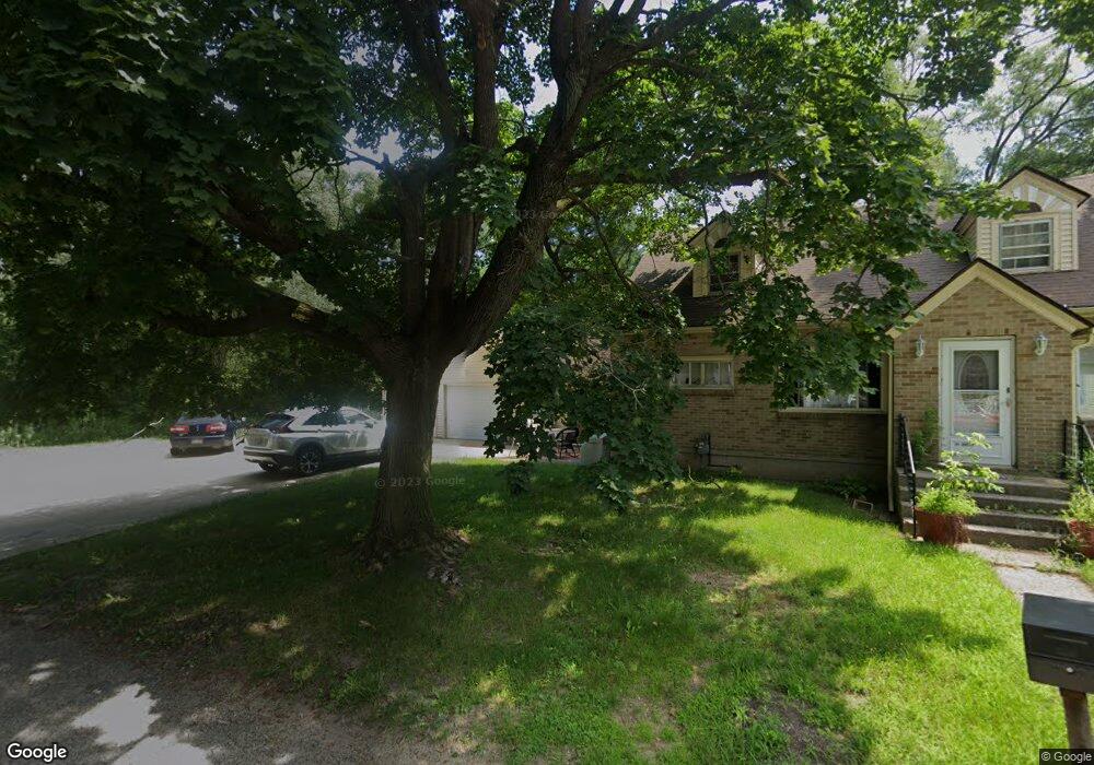
184 Johnston Cedar Springs, MI 49319
Estimated Value: $247,000 - $314,000
5
Beds
1
Bath
1,647
Sq Ft
$170/Sq Ft
Est. Value
About This Home
This home is located at 184 Johnston, Cedar Springs, MI 49319 and is currently estimated at $280,148, approximately $170 per square foot. 184 Johnston is a home located in Kent County with nearby schools including Cedar Trails Elementary School, Red Hawk Intermediate School, and Beach Elementary School.
Ownership History
Date
Name
Owned For
Owner Type
Purchase Details
Closed on
May 29, 2012
Sold by
Kingma Rogerr and Kingma Cathleen A
Bought by
Trosst Scott A and Troost Patricia A
Current Estimated Value
Home Financials for this Owner
Home Financials are based on the most recent Mortgage that was taken out on this home.
Original Mortgage
$65,902
Interest Rate
3.65%
Mortgage Type
FHA
Purchase Details
Closed on
Feb 4, 2009
Sold by
Shaw John H and Shaw Bridget A
Bought by
Federal Home Loan Mortgage Corporation
Purchase Details
Closed on
May 17, 2004
Sold by
Shaw Bridget Ann
Bought by
Shaw Bridget Ann
Create a Home Valuation Report for This Property
The Home Valuation Report is an in-depth analysis detailing your home's value as well as a comparison with similar homes in the area
Home Values in the Area
Average Home Value in this Area
Purchase History
| Date | Buyer | Sale Price | Title Company |
|---|---|---|---|
| Trosst Scott A | -- | None Available | |
| Federal Home Loan Mortgage Corporation | $53,521 | None Available | |
| Shaw Bridget Ann | -- | -- |
Source: Public Records
Mortgage History
| Date | Status | Borrower | Loan Amount |
|---|---|---|---|
| Previous Owner | Trosst Scott A | $65,902 |
Source: Public Records
Tax History Compared to Growth
Tax History
| Year | Tax Paid | Tax Assessment Tax Assessment Total Assessment is a certain percentage of the fair market value that is determined by local assessors to be the total taxable value of land and additions on the property. | Land | Improvement |
|---|---|---|---|---|
| 2025 | $2,793 | $142,200 | $0 | $0 |
| 2024 | $2,793 | $122,700 | $0 | $0 |
| 2023 | $2,658 | $105,700 | $0 | $0 |
| 2022 | $2,690 | $95,200 | $0 | $0 |
| 2021 | $2,646 | $85,600 | $0 | $0 |
| 2020 | $2,508 | $75,200 | $0 | $0 |
| 2019 | $2,435 | $69,900 | $0 | $0 |
| 2018 | $2,383 | $68,100 | $0 | $0 |
| 2017 | $2,317 | $62,600 | $0 | $0 |
| 2016 | $2,251 | $54,300 | $0 | $0 |
| 2015 | -- | $54,300 | $0 | $0 |
| 2013 | -- | $50,500 | $0 | $0 |
Source: Public Records
Map
Nearby Homes
- 249 Maple
- 197 E Elm St
- 115 E Cherry St NE
- 322 E Ash St NE
- 71 N 2nd St NE
- 11288 18 Mile Rd NE
- 11260 18 Mile Rd NE
- 5312 18 Mile Rd NE
- 69 S Main
- 520 Needlewood Dr
- 369 E Muskegon St
- 281 Ronald St NE
- 224 Ann St NE
- 361 Ronald St NE
- 551 Snow Pine Ct
- 520 Hawk Wood Ct
- 139 N 5th St NE
- 376 Needlewood Dr NE
- 561 Snow Pine Ct NE
- 531 Snow Pine Ct NE