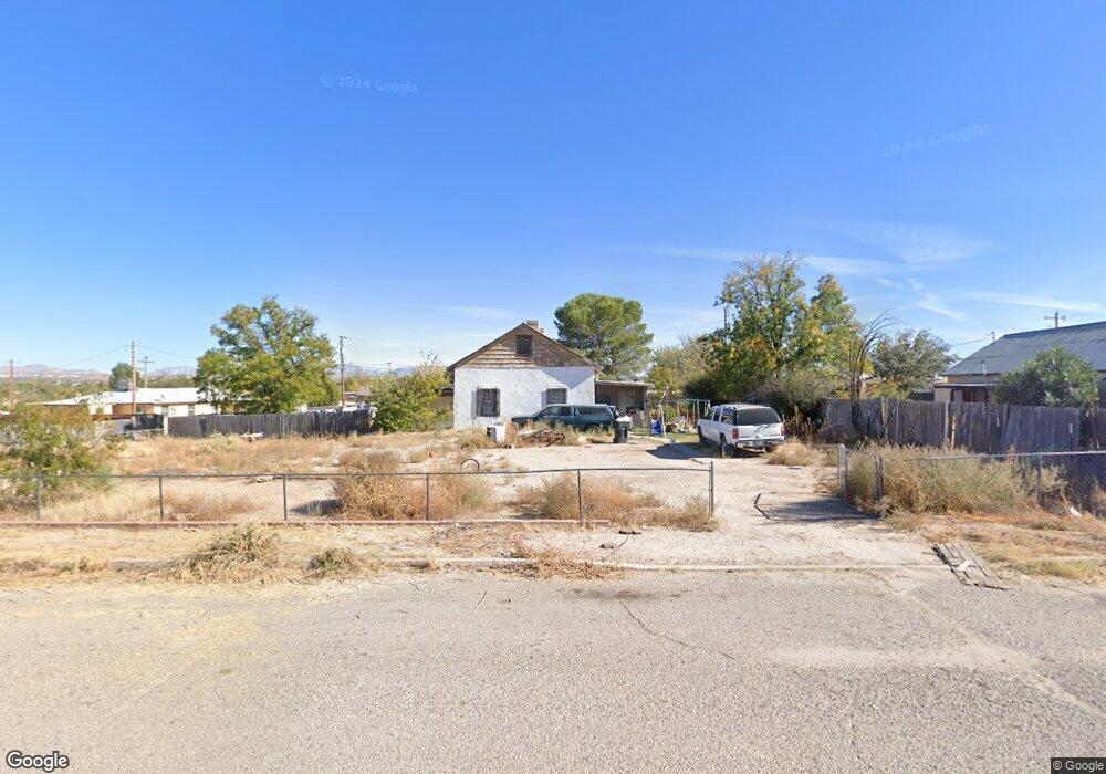
184 N Shady Ln Benson, AZ 85602
Estimated Value: $144,000 - $187,125
3
Beds
1
Bath
1,269
Sq Ft
$130/Sq Ft
Est. Value
About This Home
This home is located at 184 N Shady Ln, Benson, AZ 85602 and is currently estimated at $165,281, approximately $130 per square foot. 184 N Shady Ln is a home located in Cochise County with nearby schools including Benson Primary School, Benson Middle School, and Benson High School.
Ownership History
Date
Name
Owned For
Owner Type
Purchase Details
Closed on
Jan 14, 2015
Sold by
Righteous Capital Llc
Bought by
Jones Richard and Gonzales Jacqueline
Current Estimated Value
Purchase Details
Closed on
Mar 25, 2013
Sold by
Circle B Llc
Bought by
Righteous Capital Llc
Purchase Details
Closed on
Dec 13, 2012
Sold by
Us Bank National Association
Bought by
Circle B Llc
Purchase Details
Closed on
Sep 12, 2012
Sold by
Allen Clifton Leo and Allen Vivian Nadine
Bought by
Us Bank National Association
Purchase Details
Closed on
May 8, 2006
Sold by
Allen Vivian Nadine
Bought by
Allen Clifton Leo and Allen Vivian Nadine
Create a Home Valuation Report for This Property
The Home Valuation Report is an in-depth analysis detailing your home's value as well as a comparison with similar homes in the area
Home Values in the Area
Average Home Value in this Area
Purchase History
We collect this data history from publicly available records. To have your information removed, we recommend requesting removal directly through your county’s website.
| Date | Buyer | Sale Price | Title Company |
|---|---|---|---|
| Jones Richard | $11,000 | None Available | |
| Righteous Capital Llc | $12,120 | None Available | |
| Circle B Llc | $12,120 | None Available | |
| Us Bank National Association | $25,000 | Accommodation | |
| Allen Clifton Leo | -- | None Available |
Source: Public Records
Tax History
| Year | Tax Paid | Tax Assessment Tax Assessment Total Assessment is a certain percentage of the fair market value that is determined by local assessors to be the total taxable value of land and additions on the property. | Land | Improvement |
|---|---|---|---|---|
| 2025 | $1,102 | $12,837 | $1,680 | $11,157 |
| 2024 | $1,102 | $11,527 | $1,680 | $9,847 |
| 2023 | $1,054 | $9,818 | $1,680 | $8,138 |
| 2022 | $999 | $8,758 | $1,680 | $7,078 |
| 2021 | $1,028 | $8,101 | $1,680 | $6,421 |
| 2020 | $961 | $0 | $0 | $0 |
| 2019 | $957 | $0 | $0 | $0 |
| 2018 | $889 | $0 | $0 | $0 |
| 2017 | $919 | $0 | $0 | $0 |
| 2016 | $818 | $0 | $0 | $0 |
| 2015 | -- | $0 | $0 | $0 |
Source: Public Records
Map
Nearby Homes
- 636 E di Anne Dr
- 238 N Tawni Dr Unit 23
- 774 E Mcneil Rd Unit 28
- 635 E Pearl St
- 524 E 6th St
- 375 E 3rd St
- 262 S Gila St
- 163 S San Pedro St
- 253 E 2nd St Unit 9
- TBD E 6th St Unit 3
- TBD E 6th St
- 536 E Silverwood Ln
- TBD E Mark St
- 487 E Patrick Dr
- 590 N San Pedro St
- 442 E Silverwood Ln
- 370 E Silverwood Ln
- 162 W Flint St
- 167 W 5th St
- 0000 Vacant Land
Your Personal Tour Guide
Ask me questions while you tour the home.