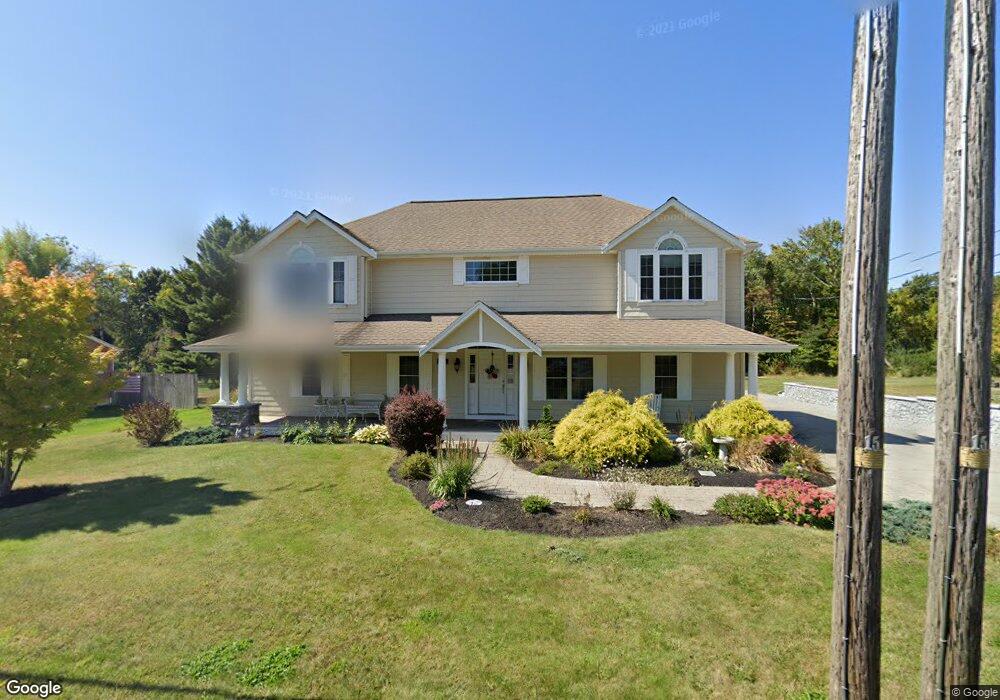
184 Sharps Lot Rd Swansea, MA 02777
Northeast Swansea NeighborhoodEstimated Value: $437,000 - $721,562
3
Beds
1
Bath
2,640
Sq Ft
$224/Sq Ft
Est. Value
About This Home
This home is located at 184 Sharps Lot Rd, Swansea, MA 02777 and is currently estimated at $592,391, approximately $224 per square foot. 184 Sharps Lot Rd is a home located in Bristol County with nearby schools including Joseph Case High School, SCEC Life Academy, and Swansea Wood School.
Ownership History
Date
Name
Owned For
Owner Type
Purchase Details
Closed on
Nov 1, 2001
Sold by
Tavares James R and Tavares Eleanor J
Bought by
Pacheco Mark and Pacheco Vicki
Current Estimated Value
Purchase Details
Closed on
Jan 27, 1994
Sold by
Obrien Scott M and Obrien Lisa M
Bought by
Pacheco Mark A and Pacheco Vicki A
Create a Home Valuation Report for This Property
The Home Valuation Report is an in-depth analysis detailing your home's value as well as a comparison with similar homes in the area
Home Values in the Area
Average Home Value in this Area
Purchase History
| Date | Buyer | Sale Price | Title Company |
|---|---|---|---|
| Pacheco Mark | $120,000 | -- | |
| Pacheco Mark A | $132,500 | -- | |
| Pacheco Mark | $120,000 | -- | |
| Pacheco Mark A | $132,500 | -- |
Source: Public Records
Mortgage History
| Date | Status | Borrower | Loan Amount |
|---|---|---|---|
| Open | Pacheco Mark A | $110,000 | |
| Closed | Pacheco Mark A | $150,000 |
Source: Public Records
Tax History Compared to Growth
Tax History
| Year | Tax Paid | Tax Assessment Tax Assessment Total Assessment is a certain percentage of the fair market value that is determined by local assessors to be the total taxable value of land and additions on the property. | Land | Improvement |
|---|---|---|---|---|
| 2025 | $6,282 | $527,000 | $176,000 | $351,000 |
| 2024 | $6,295 | $525,000 | $176,000 | $349,000 |
| 2023 | $5,809 | $442,400 | $128,700 | $313,700 |
| 2022 | $5,435 | $377,700 | $117,000 | $260,700 |
| 2021 | $5,420 | $346,800 | $117,000 | $229,800 |
| 2020 | $5,473 | $351,300 | $117,000 | $234,300 |
| 2019 | $5,467 | $352,500 | $104,400 | $248,100 |
| 2018 | $5,317 | $348,000 | $102,700 | $245,300 |
| 2017 | $4,586 | $345,300 | $102,700 | $242,600 |
| 2016 | $4,278 | $316,400 | $88,400 | $228,000 |
| 2015 | $4,148 | $315,900 | $88,400 | $227,500 |
| 2014 | $3,834 | $298,600 | $88,400 | $210,200 |
Source: Public Records
Map
Nearby Homes
- 265 Stevens Rd
- 34 Base Lodge Ln
- 0 Bark St Unit 1342599
- 0 Bark St Unit 73152576
- 745 Bark St
- 33 Rhinecliffe Rd
- 194 Hortonville Rd
- 0 Hortonville Rd Unit 73242268
- 24 Front St
- 8 2nd St
- 30 Front St
- 1067 Bark St
- 197 Alberta Ave
- 0B Cummings Rd
- 0A Cummings Rd
- Lot 11 Lynch
- 0 Proprietors Way Unit 73324662
- Lot 10 Lynch
- 122 Robin Ln
- 95 Brookside Rd
- 174 Sharps Lot Rd
- 194 Sharps Lot Rd
- 185 Sharps Lot Rd
- 163 Sharps Lot Rd
- 204 Sharps Lot Rd
- 156 Sharps Lot Rd
- 156 Sharps Lot Rd Unit 1
- 34 Merlin Dr
- 144 Sharps Lot Rd
- 44 Merlin Dr
- 121 Sharps Lot Rd
- 121 Sharplot Rd
- 52 Lancelot Terrace
- 54 Merlin Dr
- 111 Sharps Lot Rd
- 53 Lancelot Terrace
- 36 Lancelot Terrace
- 66 Merlin Dr
- 243 Sharps Lot Rd
- 51 Merlin Dr