Estimated Value: $392,000 - $429,000
4
Beds
4
Baths
2,439
Sq Ft
$167/Sq Ft
Est. Value
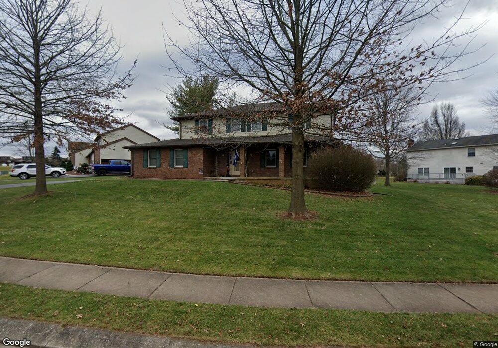
About This Home
This home is located at 1842 Austin Ln, York, PA 17408 and is currently estimated at $407,529, approximately $167 per square foot. 1842 Austin Ln is a home located in York County with nearby schools including West York Area High School, York Adventist Christian School, and Christian School of York.
Ownership History
Date
Name
Owned For
Owner Type
Purchase Details
Closed on
Feb 15, 2001
Sold by
Musso Thomas C and Mcpherson Debra E
Bought by
Hartzel Scott R and Hartzel Debra A
Current Estimated Value
Home Financials for this Owner
Home Financials are based on the most recent Mortgage that was taken out on this home.
Original Mortgage
$125,300
Outstanding Balance
$45,260
Interest Rate
7.08%
Estimated Equity
$362,269
Purchase Details
Closed on
May 12, 1988
Bought by
Musso Thomas C and Musso Debra E
Create a Home Valuation Report for This Property
The Home Valuation Report is an in-depth analysis detailing your home's value as well as a comparison with similar homes in the area
Home Values in the Area
Average Home Value in this Area
Purchase History
| Date | Buyer | Sale Price | Title Company |
|---|---|---|---|
| Hartzel Scott R | $156,650 | -- | |
| Musso Thomas C | $22,000 | -- |
Source: Public Records
Mortgage History
| Date | Status | Borrower | Loan Amount |
|---|---|---|---|
| Open | Hartzel Scott R | $125,300 |
Source: Public Records
Tax History Compared to Growth
Tax History
| Year | Tax Paid | Tax Assessment Tax Assessment Total Assessment is a certain percentage of the fair market value that is determined by local assessors to be the total taxable value of land and additions on the property. | Land | Improvement |
|---|---|---|---|---|
| 2025 | $7,532 | $223,350 | $42,980 | $180,370 |
| 2024 | $7,342 | $223,350 | $42,980 | $180,370 |
| 2023 | $6,978 | $212,270 | $42,980 | $169,290 |
| 2022 | $6,978 | $212,270 | $42,980 | $169,290 |
| 2021 | $6,766 | $212,270 | $42,980 | $169,290 |
| 2020 | $6,766 | $212,270 | $42,980 | $169,290 |
| 2019 | $6,638 | $212,270 | $42,980 | $169,290 |
| 2018 | $6,585 | $212,270 | $42,980 | $169,290 |
| 2017 | $6,384 | $212,270 | $42,980 | $169,290 |
| 2016 | $0 | $212,270 | $42,980 | $169,290 |
| 2015 | -- | $212,270 | $42,980 | $169,290 |
| 2014 | -- | $212,270 | $42,980 | $169,290 |
Source: Public Records
Map
Nearby Homes
- 1945 Normandie Dr
- 2020 Parkton Ln
- 1965 Niagara Ln
- 1837 Downing St
- 1879 Trolley Rd
- 2200 Parkton Ln
- 103 Winston Dr
- 123 Winston Dr
- 2094 Winding Rd
- 0 Colony Rd
- 1031 Willow Ridge Dr
- 2248 Heather Rd
- 1625 Haviland Rd
- 2300 Wyndhurst Ct
- 2233 Loucks Rd
- 2553 Roosevelt Ave
- 2481 Broad St
- 857 Willow Ridge Ct
- 2325 Middle St
- 2381 Sunset Ln
- 1830 Austin Ln
- 1895 Charleston Ln
- 1839 Austin Ln
- 1875 Charleston Ln
- 1845 Austin Ln
- 1822 Austin Ln
- 1851 Austin Ln
- 1865 Charleston Ln
- 0 Austin+ Unit 14 20800169
- 0 Austin Unit 8 20800161
- 1857 Austin Ln
- 1866 Austin Ln
- 1814 Austin Ln
- 1855 Charleston Ln
- 1863 Austin Ln
- 1880 Charleston Ln
- 1835 Normandie Dr
- 1872 Austin Ln
- 1869 Austin Ln
- 1860 Charleston Ln